Laurel Fork (North Fork South Branch Potomac River tributary) facts for kids
Quick facts for kids Laurel Fork |
|
|---|---|

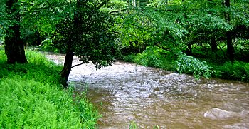
Laurel Fork near bankfull stage in 2006
|
|
|
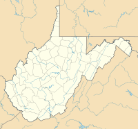
Location of the mouth of the Laurel Fork in West Virginia
|
|
| Country | United States |
| State | Virginia, West Virginia |
| County | Highland County, Virginia, Pendleton County, West Virginia |
| Physical characteristics | |
| Main source | Appalachian Mountains, Highland County, Virginia 4,094 ft (1,248 m) 38°26′16″N 79°41′15″W / 38.43778°N 79.68750°W |
| River mouth | North Fork South Branch Potomac River North of Hardscrabble, Virginia, in Pendleton County, West Virginia 2,495 ft (760 m) 38°34′13″N 79°34′13″W / 38.57028°N 79.57028°W |
| Length | 15.7 mi (25.3 km) |
The Laurel Fork is a cool stream, about 15.7-mile-long (25.3 km), that flows through parts of Virginia and West Virginia in the United States. It starts in Highland County, Virginia, where most of its journey takes place, before it reaches Pendleton County, West Virginia.
Laurel Fork eventually joins the North Fork South Branch Potomac River. This means its water becomes part of the bigger Potomac River system. The area around Laurel Fork is special because it's home to unique plants and animals. Some of these are found nowhere else in Virginia! It's also a great example of a northern boreal forest in the state.
Contents
The River's Journey: Where Laurel Fork Flows
Laurel Fork begins its journey in a mountainous area of Highland County, Virginia. This spot is close to the border with Pocahontas County, West Virginia. The stream's starting point is about 1.7 miles (2.7 km) southwest of U.S. Route 250, near the bottom of Bear Mountain. It's quite high up, at an elevation of 4,094 feet (1,248 m).
From its source, Laurel Fork flows north, winding its way under U.S. Route 250. It collects water from smaller streams called Collins Run and Blights Run. After this, Secondary Route 642 (also known as Laurel Fork Road) starts running next to the stream.
Entering the National Forest
Near the point where Mullenax Run joins Laurel Fork, the stream enters the Laurel Fork Special Management Area. This area is part of the George Washington National Forest. A little further north, Newman Run adds its water to the Laurel Fork. Route 642 then moves away from the stream's banks.
The stream continues to wind northward through the National Forest. Along the way, it meets and collects water from many other small streams. These include Bearwallow Run, Lost Run, Knotmaul Run, Christian Run, Slabcamp Run, Locust Spring Run, Buck Run, and Cold Spring Run. About 4 miles (6.4 km) northeast of Newman Run, Laurel Fork crosses into Pendleton County, West Virginia.
Journey's End: Joining Other Rivers
Once in West Virginia, Laurel Fork enters the Monongahela National Forest. Here, it takes a turn and flows eastward for about 1.5 miles (2.4 km). It picks up water from Sams Run before reaching its end point, or "mouth."
The mouth of Laurel Fork is at an elevation of 2,495 feet (760 m). This is about 15.7 miles (25.3 km) downstream from where it started. At this spot, Laurel Fork joins Straight Fork. Together, these two streams form the beginning of the North Fork South Branch Potomac River. This meeting point is about .6 miles (0.97 km) north of the small village of Hardscrabble, Virginia.
Laurel Fork's Watershed: The Land Around the River
The area that drains into Laurel Fork, called its watershed, is mostly in the Alleghany Valley in western Highland County. A small part of it extends north into Pendleton County. The Alleghany Valley is located between Allegheny Mountain to the west and Lantz Mountain to the east.
The northern part of this valley is split into two main areas. One is for Laurel Fork, and the other is for Straight Fork, which flows to the east. Middle Mountain separates these two areas. The part of the valley between Allegheny Mountain and Middle Mountain is where Laurel Fork's water comes from. This area is known for being shallow and high up. The hills around Laurel Fork are steep, with the ridges of Allegheny Mountain reaching an average height of 4,000 feet (1,200 m).
The stream flows through mostly heavily-wooded hillsides that have a moderate slope. The bottom of Laurel Fork is mainly made up of cobble (round stones) and gravel. The section of Laurel Fork within the Special Management Area in Virginia is considered an "Exceptional State Water." This is because of its "outstanding scenic beauty," amazing water life, and great opportunities for fun activities like fishing.
Amazing Nature: Plants and Animals of Laurel Fork
The Laurel Fork area is home to many different kinds of plants and animals. Some of these species are very rare or even endangered. The Laurel Fork Special Management Area (SMA), which is part of the George Washington National Forest, covers a section of the stream. In Virginia, at least twenty-five species are known to live only in the Laurel Fork SMA!
Unique Plants and Forest Life
The Laurel Fork area, especially the SMA, is considered "one of Virginia's finest examples of a northern boreal natural community." This means it's like a cool, northern forest right here in Virginia. You'll find a lot of red spruce trees here, along with Fraser Fir and Hemlock trees. Various northern hardwood trees also grow here.
Rhododendron bushes are very common in the area. In some places, they are so thick they form a "veritable barrier," meaning they are hard to walk through! It's actually the rhododendron, which people often call "laurel," that gave the Laurel Fork its name. You can also find Sphagnum mosses on the forest floor, especially under the spruce and fir trees. Berries like bearberry, gooseberry, and blueberries are also common.
Amazing Animals and Their Habitats
Three animal species that are endangered in Virginia live in the Laurel Fork SMA. These are the Virginia northern flying squirrel, the snowshoe hare, and the water shrew. These animals are only found in a few counties in Virginia. For example, the snowshoe hare is only found in Highland County!
Fishers are also seen in the Laurel Fork area. However, most of them probably just "wander" over from West Virginia. Many different kinds of birds live in the SMA, such as the red-breasted nuthatch, white-breasted nuthatch, black-throated green warbler, golden-crowned kinglet, wild turkey, and junco.
Beavers are also found in the area, especially to the west of Laurel Fork. Larger animals like white-tailed deer, which have a large population here, and black bears are also present.
Fish, especially native brook trout, are plentiful in Laurel Fork. The stream is quite large compared to other trout streams in Virginia, making it a great place for them to live.
 | William M. Jackson |
 | Juan E. Gilbert |
 | Neil deGrasse Tyson |


