
Lemei Rock facts for kids
Quick facts for kids Lemei Rock |
|
|---|---|

Lemei Rock in the Indian Heaven volcanic field
|
|
| Highest point | |
| Elevation | 5,925 ft (1,806 m) |
| Prominence | 2405 ft (733 m) |
| Geography | |
| Location | Skamania County, Washington, U.S. |
| Parent range | Cascade Range |
| Topo map | Lone Butte O46121a7 1:24,000 |
| Geology | |
| Age of rock | Pleistocene and Holocene |
| Mountain type | shield volcano |
| Volcanic arc | Cascade Volcanic Arc |
| Last eruption | 8,200 years ago |
| Climbing | |
| Easiest route | Lemei Trail, Indian Heaven Trail, with rock scrambling |
Lemei Rock is a large, gently sloped volcano called a shield volcano. It's part of a group of volcanoes in the Indian Heaven area of Washington, United States. You can find it right between two famous volcanoes, Mount St. Helens and Mount Adams. Lemei Rock is the tallest point in this area, standing at about 5,925 feet (1,806 meters) tall. It formed a very long time ago, during the Pleistocene and Holocene periods.
Contents
Exploring Lemei Rock's Location
Lemei Rock is the highest point inside the Indian Heaven Wilderness in Washington. It stands out quite a bit from the land around it, by about 2,405 feet (733 meters). On clear days, people hiking here can see amazing views of four other volcanoes: Mount Adams, Mount Hood, Mount St. Helens, and Mount Rainier.
The top of this shield volcano has a bowl-shaped area called a volcanic crater. Even though the edge of the crater usually doesn't have snow or ice, snow often stays on the very top of Lemei Rock until July! There's a small lake called Lake Wapiki inside the crater, just below the highest point of Lemei Rock.
Water from Lemei Rock flows in different directions.
- Lost and Dry Creeks flow from the southeast side and join the White Salmon River.
- Smokey, Little Goose, and Cultus Creeks flow from the east and northeast. They join Trout Lake Creek, which then flows into the White Salmon River near Trout Lake.
- Rush Creek flows from the west side and joins the Lewis River.
How Lemei Rock Formed
Lemei Rock is one of many shield volcanoes in the Indian Heaven Volcanic Field. These volcanoes often have smaller cinder cones and spatter cones on top. This volcanic field has about 60 places where eruptions happened. These spots are spread out along a 30-kilometer (19-mile) long line called the Indian Heaven fissure zone.
The entire volcanic field covers about 600 square kilometers (230 square miles). It holds about 100 cubic kilometers (24 cubic miles) of volcanic rock. This field is part of a much larger area of basalt rock in southern Washington. This larger area also includes the King Mountain fissure zone, where Mount Adams was built.
Hiking and Fun at Lemei Rock

The area around Lemei Rock is great for fishing and hiking, especially in the Indian Heaven Wilderness. This wilderness is famous for its high mountain meadows scattered among the volcanic peaks. The Pacific Crest National Scenic Trail, a long hiking path, goes right through this volcanic field and the Indian Heaven Wilderness.
When you're hiking here, you can enjoy the many lakes and the views of four nearby volcanoes: Mount Adams, Mount Hood, Mount St. Helens, and Mount Rainier.
There are a few main trails around Lemei Rock:
- The Lemei Trail climbs up the east side of Lemei Rock.
- The Wapiki Trail goes from the Lemei Trail down to the beautiful blue Wapiki Lake, which is the "crater lake" of Lemei Rock.
- The Filloon Trail starts from the Little Goose Campground and connects with the Lemei Trail before Lake Comcomly.
The Cultus Creek Campground has fifty campsites and is a popular spot for picking berries. It's right on the edge of the Indian Heaven Wilderness. This campground offers two main trailheads: Indian Heaven Trail #33 and Cultus Creek Trail #108. It also gives visitors easy access to the Indian Heaven Wilderness, which is well-known for its huckleberries and the volcanic field it's part of.
Images for kids
-
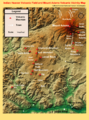
Indian Heaven Volcanic Field and Mount Adams Volcanic Vicinity Digital Relief Map showing Lemei Rock and the various other peaks that make up the volcanic field.

