Liao River facts for kids
Quick facts for kids Liao River |
|
|---|---|
 |
|

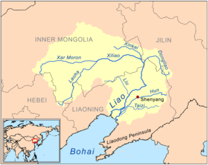
Map of the Liao River drainage basin
|
|
| Native name | 辽河 |
| Other name(s) | Liao He |
| Country | China |
| Province | Hebei, Inner Mongolia, Jilin, Liaoning |
| Physical characteristics | |
| Main source | various sources of its tributaries |
| River mouth | Liaodong Bay |
| Length | 1,345 km (836 mi) |
| Basin features | |
| Basin size | 232,000 km2 (90,000 sq mi) |
The Liao River (simplified Chinese: 辽河; traditional Chinese: 遼河; pinyin: Liáo Hé) is a very important river in southern Northeast China. It is one of the seven main river systems in China. The river gets its name from the Liao region, an old name for southern Manchuria. Other places like Liaoning province, Liaodong Peninsula, and the Liao dynasty also got their names from this region. Many people in Northeast China call the Liao River their "mother river."
This river is about 1,345 kilometres (836 mi) long. Its catchment basin (the area of land where water flows into the river) covers over 232,000 square kilometres (90,000 sq mi). However, the amount of water flowing in it is quite small, only about 500 cubic metres per second (18,000 cu ft/s). This is much less than other big rivers in China. The Liao River carries a lot of sediment (tiny bits of rock and soil). This is because it flows through soft, powdery soil called loess.
The Liao River is also a key geographical landmark. It divides the modern Liaoning province into two main areas. These are Liaodong (meaning "east of Liao River") and Liaoxi ("west of Liao River").
Contents
How the Liao River Flows
The Liao River is formed when two main rivers join together. These are the Xiliao River from the west and the Dongliao River from the east.
The Western Branch: Xiliao River
The western branch, the Xiliao River, is entirely in Inner Mongolia. It starts when the Xar Moron River and the Laoha River meet. Another river, the Xinkai River, also joins it further down.
The Eastern Branch: Dongliao River
The eastern branch, the Dongliao River, begins in western Jilin Province. It flows in an S-shape before meeting the Xiliao River. This meeting point is where Liaoning, Jilin, and Inner Mongolia almost touch.
The Main Liao River
After these two branches join, the main Liao River flows into Liaoning Province. It then travels south through the Northeast China Plain. Many smaller rivers join it along the way. Near Pingdingbao Town, the river turns west. After more rivers join, it sometimes gets the nickname Juliu River, which means "giant stream river."
The Liao River then flows southwest. Historically, it used to split into two smaller rivers, forming the Liao River Delta.
Changes to the River's Flow
One of the split rivers was the Shuangtaizi River. It received the Raoyang River and flowed into the Liaodong Bay. The other split river was the Wailiao River. This was the main part of the lower Liao River. The Wailiao River picked up two large rivers, the Hun River and the Taizi River. When these three rivers met, it was called the "Trident River." After this, the Wailiao River became the Daliao River and flowed into the Liaodong Bay.
However, the Liao River Delta area is very flat and has soft soil. The river's paths often changed over time. This, along with the risk of storm surges (big waves from storms) because the land is low, caused big problems with flood control. The city of Yingkou, which is home to 2 million people, was especially at risk from floods.
In 1958, engineers built a project to block off the Wailiao River upstream. This sent all the water from the main Liao River towards the Shuangtaizi River. The Shuangtaizi River was later renamed simply the "Liao River" in 2011. This project also separated the Hun River and Taizi River from the Liao River system. So, since 1958, the Daliao River system is considered its own separate river system. The Hun and Taizi Rivers are no longer part of the Liao River. Because the Wailiao River's flow was cut off, the Liao River no longer splits into smaller rivers. This means the Liao River Delta technically stopped existing in 1958. However, people still use the term "Liao River Delta" to describe the area around Panjin.
Rivers Joining the Liao River
Main Rivers Joining the Liao River
- Xiliao River (西辽河, "Western Liao River"): This is the largest river that joins the Liao River. It is also known as Huang River. It flows for 449 kilometres (279 mi) and drains a large area of 136,000 square kilometres (53,000 sq mi). The Xiliao River is formed by the Laoha River and the Xar Moron River. It flows entirely within Inner Mongolia. The Xinkai River also joins it further downstream.
- Dongliao River (东辽河, "Eastern Liao River"): This is the other main river that joins the Liao River. It flows for 360 kilometres (220 mi) and drains an area of 11,500 square kilometres (4,400 sq mi). It has many smaller rivers joining it. The Dongliao River starts in the mountains near Dongliao County in Jilin Province. Most of this river is in Jilin. It then flows through Liaoning Province for a short bit before turning back to Jilin and then southwest to join the Xiliao River.
Smaller Rivers Joining the Liao River
These rivers flow into the main Liao River as it passes through Liaoning Province:
- Sutai River (苏台河)
- Qing River (清河)
- Chai River (柴河)
- Fan River (泛河)
- Xiushui River (秀水河)
- Yangximu River (养息牧河)
- Liu River (柳河)
- Raoyang River (绕阳河)
Rivers That Used to Join the Liao River
- Hun River (浑河, "muddy river"): This river was once the second largest river joining the Liao River. It was also known as Little Liao River or Shen River. It flows for 415 kilometres (258 mi) and drains an area of 11,500 square kilometres (4,400 sq mi). The Hun River flows through the most populated parts of Liaoning Province, including the capital city Shenyang and the city of Fushun. It got its current name because its fast flow and high sediment load make it look muddy. The Hun River starts in the Qian Mountains. It flows into the large Dahuofang Reservoir, which provides drinking water to many nearby cities.
- Before 1958, the Hun River joined the Wailiao River and then the Taizi River. This meeting point was called "the Trident River." Together, they formed the Daliao River, which flowed into the Liaodong Bay. But in 1958, a project was done to control floods near Yingkou. The Wailiao River's upstream flow was blocked. This sent the Liao River's water towards the Shuangtaizi River instead. This separated the Hun River and Taizi River from the main Liao River system. So, since 1958, the Hun and Taizi Rivers are considered their own separate river system. They no longer join the Liao River.
- Taizi River (太子河, "crown prince river"): This river was once the third largest river joining the Liao River. It was also known as Yan River or Liang River. It flows for 413 kilometres (257 mi) and drains an area of 13,900 square kilometres (5,400 sq mi). The Taizi River, like the Hun River, flows through important farming and industrial areas in southern Liaoning. These include the cities of Benxi, Anshan, and Liaoyang. The Taizi River also has many smaller rivers joining it. Its source is in the hills between Benxi and Fushun. It is famous for the Benxi Water Caves. Like the Hun River, the Taizi River no longer joins the Liao River since the Wailiao River's flow was cut off in 1958.
See also
 In Spanish: Río Liao para niños
- North China Plain
- Loess Plateau
- List of rivers of Asia
- List of rivers in China
 | Jackie Robinson |
 | Jack Johnson |
 | Althea Gibson |
 | Arthur Ashe |
 | Muhammad Ali |

