
Line of Property facts for kids
The Line of Property was an important border in early American history. It separated lands belonging to Native American tribes from the lands claimed by the Thirteen Colonies. This line was officially created in 1768 by the Treaty of Fort Stanwix. This agreement was made between British officials and the powerful Iroquois tribes. In western Pennsylvania, this border was also known as the Purchase line.

Contents
Understanding the Treaty Line
The 1768 Treaty of Fort Stanwix described a long line that would serve as the new boundary. This line started far to the southwest and moved northeast. It began where the Tennessee River meets the Ohio River in what is now Paducah, Kentucky.
From there, the line followed the south side of the Ohio River. It went through most of modern-day Kentucky and all of West Virginia. The line then reached Pittsburgh, Pennsylvania, where the Allegheny and Monongahela rivers join to form the Ohio.
The border continued north along the Allegheny River. It then moved eastward through Pennsylvania. It crossed the West Branch Susquehanna River near Jersey Shore, Pennsylvania. The line then followed various creeks and hills.
Finally, the line crossed the Susquehanna River again near Towanda, Pennsylvania. It continued east into New York. The border then went up the Delaware River and eventually ended near Rome, New York. This detailed path helped define the new territories.

Where the Line Actually Went
The starting point of the Line of Property was indeed where the Tennessee River meets the Ohio River in Kentucky. The line followed the south bank of the Ohio River. It went along the borders of what are now Kentucky and West Virginia. It continued all the way to Pittsburgh.
After Pittsburgh, the line followed the Allegheny River north. Then, it went from Kittanning, Pennsylvania, to a specific fork of the West Branch Susquehanna River. This point is now known as Cherry Tree, Pennsylvania.
From Cherry Tree, the line followed the winding path of the West Branch Susquehanna River. It went through places like Clearfield, Pennsylvania, and Lock Haven, Pennsylvania. It continued east-northeast to where Pine Creek meets the West Branch, near Jersey Shore, Pennsylvania.
The next part of the line was tricky to figure out. The treaty mentioned "Burnetts Hills," but their exact location was unclear. Also, the treaty didn't say how far to follow Pine Creek.
One part that was clear was the lowest section of Towanda Creek. This part runs from Monroeton to Towanda, Pennsylvania.
There were two main ideas about how the line went from Jersey Shore to Towanda Creek. One idea was that it followed the main branch of Towanda Creek. This creek runs along the base of Barclay Mountain. Another idea was that it followed a different path through "Burnett's Ridge" in Lycoming County. This path would have been easier to travel.
The old map from 1768 wasn't very accurate. It seemed to lean towards the second idea. This second path would have given more land to the Native Americans. It would have included valuable valley lands and hunting areas.
From Towanda, the line followed the East Branch of the Susquehanna River. It went past Athens, Pennsylvania, and then east to Owego, New York.
The section of the line east of Owego was also difficult. The people who wrote the treaty didn't have good maps. They thought a straight line from Owego would hit the Delaware River. But it wouldn't have. So, the line was likely adjusted to reach the Delaware River at Deposit, New York. This spot forms a natural corner in the river.
From Deposit, the line went straight north-east to the Unadilla River. This river now forms part of the border between counties in New York. The line then continued northwest. It ended near Rome, New York. This meant that Fort Stanwix itself was on the side of the colonists. Today, stone markers show where the line went through the Hamilton College campus.

What Happened Because of the Line
This new border had big effects. The first part of the line gave most of what is now Kentucky and West Virginia to the Colony of Virginia.
The Line of Property also greatly expanded the area claimed by the colonies. This was especially true in Pennsylvania. It also added a small part of New York State to the colonial side. This area was east of the Unadilla River.
The Iroquois tribes gave up only a small area in New York. They gave up a larger area in Pennsylvania. But they also gave up a huge amount of land that was actually south of where they usually lived or controlled.
Maps
-
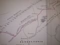
Fragment of Guy Johnson's map of the Line of Property 1768; section centered at Burnetts Hills
-
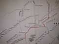
Fragment of Guy Johnson's map of the Line of Property 1768; section centered at Owego
-
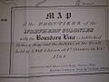
Title block of Guy Johnson's map of the Line of Property 1768


