
List of Sites of Special Scientific Interest in Cheshire facts for kids

Imagine special places in Cheshire, England, that are protected because they are super important for nature! These places are called Sites of Special Scientific Interest (SSSIs). There are 63 of them in Cheshire, covering a huge area of nearly 20,000 hectares (that's about 49,000 acres!).
Most of these SSSIs, 51 of them, are protected for their amazing plants and animals (their biological interest). Seven are special because of their rocks and landforms (their geological features). And five sites are important for both!
Contents
What are SSSIs and Why are They Special?
SSSIs are protected by a law called the Wildlife and Countryside Act 1981. This law says that these sites must be chosen because they have special plants, animals, or unique geological features. It's like giving them a "protected" badge to make sure they stay healthy and safe for future generations.
Who Looks After SSSIs?
In England, a group called Natural England is in charge of finding and looking after these special sites. They took over this important job in 2006. For sites that are special because of their rocks and landforms, another group called the Joint Nature Conservation Committee helps identify them across the whole UK.
Natural England uses a system of "Areas of Search" to help them organize and manage these sites. These areas are similar to the old county boundaries from 1974 to 1996. Cheshire's "Area of Search" is a bit different from its current county borders.
Cheshire's Natural Areas
Since the 1990s, nature protection in England has also focused on 120 "natural areas." These are regions defined by their natural features, not by government boundaries. The Cheshire Area of Search includes four of these natural areas, each with its own unique habitats.

The Meres and Mosses Area
Most of Cheshire's SSSIs are found in the Meres and Mosses natural area. This area covers a large part of the county and stretches into Shropshire and Staffordshire. It's mostly flat or gently rolling farmland, usually less than 100 meters high.
Even though there's a lot of farming, this area has many different wetland habitats. These include:
- Mosses (which are a type of bog or peatland).
- Swamps and fens.
- Meres (which are small, shallow lakes).
- Thousands of small ponds.
Some unique "flashes" are also found here. These are pools formed when the ground sinks after salt is extracted from underground. They contain rare inland salt marsh habitats, which are very special globally.
You won't find much ancient woodland in this area, but some exists on the slopes of the Mid Cheshire Ridge and along river valleys in the north. Lowland heath habitat is very rare, only found in a few spots. The Mid Cheshire Ridge is a hill range that rises sharply in the middle of the plain. Its Triassic sandstone rocks are visible at the Raw Head geological site.

The South West Peak Area
Two large SSSIs, Goyt Valley and Leek Moors, are on the eastern edge of Cheshire. They are part of the South West Peak natural area, which is within the Peak District. These sites are much higher up than other Cheshire SSSIs. They are made of millstone grit and shale rocks.
Here, you'll find different upland habitats. These are mainly:
The Urban Mersey Basin Area
Ten SSSIs are located in Warrington, Halton, and the former area of Ellesmere Port & Neston in the north-west of Cheshire. This region is part of the Urban Mersey Basin natural area, which also covers Greater Manchester and Merseyside.
Even though this is one of the most populated areas in Europe, much of the Cheshire part is farmland. The natural habitats here include:
- Ancient woodland.
- Raised bog (a type of peat bog that grows upwards).
- Freshwater wetlands.
The Rixton Clay Pits site is an example of land that used to be industrial but is now protected. Also, old railway cuttings here show interesting geological features.
The Liverpool Bay Coastal Area
Finally, the Liverpool Bay coastal region has two large estuaries: the Mersey and Dee. These are the biggest SSSIs in Cheshire! Estuaries are places where rivers meet the sea, creating unique environments for wildlife.
Images for kids
-
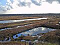
Mosslands, like Risley Moss, are important habitats in Cheshire
-
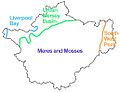
This map shows the general locations of Cheshire's four natural areas
-
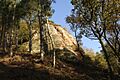
Raw Head is one of Cheshire's special geological SSSIs
