
List of demolished places of worship in West Sussex facts for kids
This article is about churches, chapels, and other places of worship in West Sussex, England, that have been pulled down and not rebuilt in the same spot. Over 80 such buildings have been lost across the county. This happened for various reasons, including fewer people attending services, problems with the buildings themselves, new shops or homes being built, and sometimes even vandalism. Big towns like Bognor Regis, Littlehampton, Worthing, and the city of Chichester have each lost several religious buildings. Even small villages like Copsale, Iping Marsh, and South Mundham have seen their chapels disappear.
This list focuses on public places of worship that were completely demolished. It doesn't include private chapels (like those in hospitals or schools) or churches that are still standing but are just ruins. Also, if an old church was pulled down to build a brand new church right on the same spot, it's not included here. However, if a church was demolished and a new one was built somewhere else, like in Chichester (St Richard's Church) or Burgess Hill (the Baptist church), then details about the old building are included.

Many of the churches listed here were built in the 1800s and were demolished after World War II. The government started protecting important old buildings in the 1940s. However, it wasn't until later in the 1900s that churches from the Victorian era (Queen Victoria's time) started getting special protection from being pulled down. By 1980, almost 80 out of about 600 Victorian places of worship in Sussex had been lost. Many buildings were saved only by luck or by a few determined people. There wasn't a big plan to save old churches that were no longer needed. Since about 1980, fewer places of worship have been lost. This is because groups like the Churches Conservation Trust and Friends of Friendless Churches have become more active. Still, some very beautiful churches have been lost, such as St Richard's Church in Three Bridges, St John the Baptist's Church in Bognor Regis, and the large St Peter's Church at Treyford, which was sometimes called the "Cathedral of the Downs".
Contents
Lost Places of Worship in West Sussex
| Name | Location | Area | Religion | Built | Demolished | What's there now | Notes |
|---|---|---|---|---|---|---|---|
| Rocks Lane Baptist Chapel | Balcombe 51°03′26″N 0°08′13″W / 51.0571°N 0.1369°W |
Mid Sussex | Baptist | 1858 | around 1950 | Empty land | This small, wooden building used to be a shop before it became a Baptist chapel in 1858. The church group stopped meeting there in the early 1900s, but the building stayed until around 1950. |
| Gospel Hall | Billingshurst 51°00′49″N 0°27′04″W / 51.0135°N 0.4512°W |
Horsham | Plymouth Brethren | 1888 | 1962 | Homes | Built for the Brethren, this hall was later used by The Salvation Army and Baptists. In 1925, it became a Roman Catholic church. It was used until a new Catholic church was built nearby in 1961–62, then it was pulled down. |
| Gingers Chapel | Billingshurst | Horsham | Congregational | 1815 | 1868 | This chapel was made from an old officers' mess building from the Napoleonic Wars. It was used until 1868 when a new church was built in the village. | |
| St Alban's Chapel | Bognor Regis 50°47′13″N 0°40′02″W / 50.7870°N 0.6672°W |
Arun | Anglican | 1793 | 1857 | Park | The person who first developed Bognor, Sir Richard Hotham, built this chapel next to his home in 1793. It was used for church services, but the next owner of the house pulled it down. |
| St John the Evangelist's Church | Bognor Regis 50°46′57″N 0°40′39″W / 50.7824°N 0.6775°W |
Arun | Anglican | 1821 | 1891 | Car park | This church was the main church for Bognor between 1873 and 1882. It was a Gothic-style building with a tower built in 1830. The church was pulled down in 1891, but the tower stayed until 1961. |
| St John the Baptist's Church | Bognor Regis 50°47′07″N 0°40′27″W / 50.7852°N 0.6741°W |
Arun | Anglican | 1882 | 1972 | Shops (Boots) | This church, built in 1882, became the town's main church. It was made of flint and red brick. However, because Bognor Regis had another large church, St Wilfrid's, St John the Baptist's was no longer needed and was demolished in 1972. |
| St Peter's Church | Bognor Regis 50°47′33″N 0°41′27″W / 50.7925°N 0.6907°W |
Arun | Anglican | 1939 | 1997 | Homes | This building was both a church and a hall. It was opened in 1939. Permission was given to pull it down and build houses on the site in 1997. |
| High Street Congregational Church | Bognor Regis 50°47′02″N 0°40′23″W / 50.7838°N 0.6731°W |
Arun | Congregational | 1866 | 1929 | Shops | This church was built in 1866 in a Gothic style, mostly with flint. A bigger church replaced it in 1930, and the old one was pulled down. |
| Hanover Chapel | Bognor Regis 50°47′06″N 0°40′29″W / 50.7849°N 0.6746°W |
Arun | Independent | 1826 | 1966 | Shops | This chapel was only used for religious services until 1869. After that, it was used for many other things, including a theatre, before it was demolished. |
| Wesleyan Methodist Chapel | Bognor Regis 50°47′00″N 0°40′26″W / 50.7834°N 0.6738°W |
Arun | Methodist | 1840 | 1980 | Shops | This chapel, built in 1840, was used for worship for 85 years. It was replaced by a larger building in 1925. Until it was pulled down, it was used as a garage. |
| Primitive Methodist Chapel | Bognor Regis 50°46′56″N 0°40′42″W / 50.7823°N 0.6783°W |
Arun | Methodist | 1876 | 1975 | Homes | This Gothic-style chapel was on a central square. It was mostly made of flint with some red brick. In 1932, it became a Brethren Gospel Hall and was still used by them in 1963. |
| Burgess Hill Baptist Tabernacle | Burgess Hill 50°57′22″N 0°07′58″W / 50.9560°N 0.1327°W |
Mid Sussex | Baptist | 1894 | 1970 | Shops (Lidl) | This church was designed in 1894. The church group moved to a new building in 1965. The old church was then pulled down in 1970 to make way for a shopping centre. It was a Gothic-style building of red brick and stone. |
| Chichester Congregational Church | Chichester 50°50′04″N 0°46′48″W / 50.8345°N 0.7800°W |
Chichester | Congregational | 1892 | 1980 | Shops | This church, built in 1892, was made of ragstone in a Gothic style. It was officially closed as a place of worship in 1980. |
| Christ Church | Chichester 50°50′02″N 0°46′47″W / 50.8338°N 0.7797°W |
Chichester | Methodist | 1876 | 1981 | Shops (Christ Church Buildings) | This church was on South Street and was pulled down in the 1980s. Its church group joined with the Congregational church and moved into a new building together in 1982. It was built in an Italian-Gothic style using Portland stone. |
| Broyle Road Methodist Chapel | Chichester 50°50′36″N 0°46′48″W / 50.8434°N 0.7799°W |
Chichester | Methodist | 1875 | 1965 | Homes | This chapel was used for religious services from 1875 until 1956. It was a flint building with red brick details and tall, narrow windows. |
| East Walls Methodist Chapel | Chichester 50°50′11″N 0°46′20″W / 50.8364°N 0.7722°W |
Chichester | Methodist | 1840 | around 1910 | Shops | A brick chapel in a simple, traditional style, this was opened near the city walls in 1840. |
| St Richard's Church | Chichester 50°50′03″N 0°46′47″W / 50.8341°N 0.7797°W |
Chichester | Roman Catholic | 1855 | 1958 | Shops | Chichester's first Roman Catholic church was replaced by another church with the same name on a different site when it was pulled down in 1958. It was a Gothic-style building of flint and stone. |
| Cinder Hill Mission Church | Cinder Hill, Horsted Keynes | Mid Sussex | Anglican | 1919 | Empty land | This small hut was first used as a church for soldiers during wartime on the Sussex coast. In 1919, it was moved to Cinder Hill and used for Sunday school and occasional church services. | |
| St Paulinus' Church | Cokeham, Sompting 50°49′57″N 0°20′09″W / 50.8326°N 0.3359°W |
Adur | Roman Catholic | 1935 | 1973 | Homes | A Roman Catholic church for the Sompting area was built in 1935. It closed in 1973, and the land was sold for houses. People who went there then joined the church at nearby Lancing. |
| Mar's Hill Chapel | Colgate 51°04′53″N 0°14′37″W / 51.0813°N 0.2437°W |
Horsham | Baptist | 1890 | around 1976 | Homes | This chapel was built for Baptists in 1890. Before that, people had to travel to Handcross or Horsham for church. The brick building could hold 100 people. |
| Church of the Holy Nativity | Copsale 51°00′42″N 0°19′54″W / 51.0117°N 0.3317°W |
Horsham | Anglican | 1859 | around 1965 | Empty land | This small village in the Nuthurst area got a chapel in 1859. The red-brick Gothic-style building was made bigger around 1915. It closed and was pulled down around 1965. |
| Station Road Baptist Church | Crawley 51°06′46″N 0°11′24″W / 51.1129°N 0.1899°W |
Crawley | Baptist | 1893 | around 1944 | Car park | This chapel was built of red brick and stone. It was badly damaged by bombs in 1943 and had to be pulled down. A new church was built in the West Green area in 1954. |
| Bethel Strict Baptist Chapel | Crawley 51°06′48″N 0°11′36″W / 51.1133°N 0.1932°W |
Crawley | Baptist | 1858 | 2003 | Shops (Asda) | Strict Baptists met in a cottage from about 1810, and this chapel was built in 1858. It closed in 1969 but was reopened in 1971. The building was covered in stucco and had an entrance porch. It was demolished in 2003. |
| Trinity Congregational Church | Crawley 51°06′48″N 0°11′31″W / 51.1133°N 0.1920°W |
Crawley | Congregational | 1863 | 1962 | Shops (Asda) | The first chapel on this site opened in 1835. This brick Gothic-style church replaced it in 1863. It was used until a new church with the same name was built in the Ifield area in 1962. |
| St Mary's Church | Duncton 50°56′24″N 0°38′10″W / 50.9400°N 0.6361°W |
Chichester | Anglican | before 1548 | 1876 | Empty land | St Mary's was originally a small chapel for a larger church, but it became its own parish church in 1692. It was replaced by a new church, Holy Trinity, in 1866 and then pulled down in 1876. |
| New Life Church | Durrington 50°50′07″N 0°24′26″W / 50.8354°N 0.4073°W |
Worthing | Baptist | 1939 | 2022 | Homes | This church got its name in 1985 but started as a Free Church in 1912, becoming Baptist in 1943. The original chapel was replaced by a brick building in 1939. The church moved to a new, much larger building, and the old chapel was pulled down for houses. |
| St Michael's Church | Durrington 50°50′24″N 0°24′11″W / 50.8401°N 0.4031°W |
Worthing | Roman Catholic | 1938 | 1966 | Homes | Durrington's Roman Catholic church area was created in 1927. The first chapel was built in 1938. It closed and was pulled down when a new church was built in 1966. |
| St Luke's Church | East Grinstead 51°08′14″N 0°00′02″W / 51.1373°N 0.0005°W |
Mid Sussex | Anglican | 1954 | 2015 | Homes | This church opened in 1954 and served the Stone Quarry area of East Grinstead. It was made of brown and yellow brick with large glass sections. The last service was in June 2014, and the church was pulled down in 2015 to build houses. |
| Providence Chapel | East Grinstead 51°07′48″N 0°01′00″W / 51.1299°N 0.0167°W |
Mid Sussex | Baptist | 1894 | around 1967 | Car park | This red-brick chapel had stone details and was built in a Gothic style. It closed before 1967. |
| Rocks Chapel | East Grinstead | Mid Sussex | Congregational | 1850 | A group of people who left another church started this chapel. They later opened a bigger chapel nearby, and this building was used by Methodists for a while. | ||
| London Road Methodist Church | East Grinstead 51°07′30″N 0°00′37″W / 51.1250°N 0.0104°W |
Mid Sussex | Methodist | 1881 | 1937 | Shops | East Grinstead's first Methodist church was built of stone in a Gothic style in 1881. It was replaced by Trinity Methodist Church nearby. |
| Emmanuel Church | East Worthing 50°49′01″N 0°21′03″W / 50.8169°N 0.3507°W |
Worthing | Anglican | 1977 | 2008 | Homes (Emmanuel Court) | This octagonal brick church replaced an older Emmanuel Church. The original building was put up in 1911 and later became the church hall. Both buildings were bought and pulled down to build houses. |
| Mission Hall | Elsted Marsh 50°58′46″N 0°48′41″W / 50.9795°N 0.8115°W |
Chichester | Nondenominational | around 1884 | around 1971 | Homes | This mission hall near Elsted railway station was registered for worship in 1884. |
| Dependants' Chapel | Felpham 50°47′43″N 0°38′12″W / 50.7954°N 0.6366°W |
Arun | Society of Dependants | around 1898 | around 1939 | Car park | This small local religious group built an iron building for their services. For a time in the 1930s, it was shared with Methodists until they built their own church. |
| Primitive Methodist Chapel | Fishbourne 50°50′08″N 0°48′37″W / 50.8355°N 0.8103°W |
Chichester | Methodist | 1872 | 1971 | Homes | Fishbourne's Methodist chapel was a red-brick building with decorative wooden trim and tall, narrow windows. It was pulled down to build houses. |
| Fishersgate Particular Baptist Chapel | Fishersgate 50°49′55″N 0°13′04″W / 50.8319°N 0.2178°W |
Adur | Baptist | 1868 | around 1960 | Industrial area | This chapel closed in the 1890s but remained standing until the area was redeveloped for industry. |
| Congregational Church | Fishersgate 50°49′56″N 0°13′09″W / 50.8322°N 0.2193°W |
Adur | Congregational | 1879 | around 1950 | Industrial area | A building was put up in 1879. It was originally for any Christian group but later became Congregational. It was replaced by another chapel around 1910, but the building stayed until industrial development took place. |
| Congregational Mission Room | Fishersgate 50°49′58″N 0°13′24″W / 50.8327°N 0.2232°W |
Adur | Congregational | around 1910 | 2002 | Empty land | This building was likely built to replace the old Congregational church nearby. It was only used for religious services until 1947. After that, it became a community hall until it was pulled down. |
| Mission Room | Fontwell 50°51′14″N 0°38′39″W / 50.8539°N 0.6442°W |
Arun | Anglican | 1930 | after 1974 | Homes | This Anglican mission chapel was connected to St Mary's Church at Walberton. It was also used for social activities and stayed until 1974 or later, even though it stopped being used for church services around 1957. |
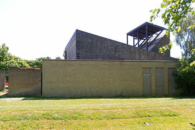
| Church of the Good Shepherd | Franklands Village, Haywards Heath 50°59′48″N 0°05′09″W / 50.9968°N 0.0857°W |
Mid Sussex | Anglican | 1964 | 2016 | Empty land | This church was designed in 1964–65. It had a steep roof with large glass areas and cedar wood walls. It was no longer needed in 2003 and stayed empty until it was pulled down in 2016. |
| St John the Baptist's Chapel | Freshfield, Horsted Keynes 51°00′48″N 0°01′51″W / 51.0132°N 0.0309°W |
Mid Sussex | Anglican | 1897 | around 1967 | Empty land | Originally called Freshfield Mission Church, this was built in 1897 on land that was given for free. It was used for occasional services and Sunday school. |
| Goring and Ferring Free Church | Goring-by-Sea 50°48′54″N 0°25′59″W / 50.8150°N 0.4331°W |
Worthing | Evangelical | 1950 | 1986 | Homes | This "plain brick hall" was built in 1950 for an Evangelical group. The group stopped supporting the minister in 1977, which led to the church closing. The building was pulled down, and the land was sold for houses. |
| St Wilfrid's Mission Church | Hambrook 50°51′15″N 0°52′43″W / 50.8541°N 0.8786°W |
Chichester | Anglican | 1923 | around 1973 | Homes | This was a small chapel connected to St Mary's Church in Chidham. It was still standing in 1973 but was later replaced by a new church with the same name nearby. |
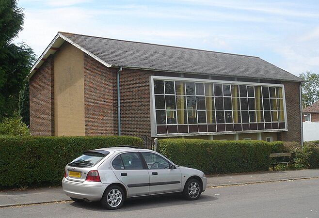
| Primitive Methodist Mission Room | Horsham 51°04′10″N 0°19′54″W / 51.0694°N 0.3316°W |
Horsham | Methodist | 1885 | 2018 | Homes | This brick building from 1885 was in the northwest of Horsham. It closed as a church by the early 1920s. It was later used by the British Red Cross but was sold and pulled down for housing in 2018. |
| St John the Evangelist's Chapel | Horsham 51°03′49″N 0°19′55″W / 51.0636°N 0.3319°W |
Horsham | Roman Catholic | 1865 | around 1983 | Shops | This church replaced Horsham's first Roman Catholic place of worship. The new Gothic-style sandstone church was built in 1865. Another new church with the same name was built opposite in 1923. Hadfield's building closed and was changed for shops before being pulled down. |
| St Edward and St Louis Church | Imberhorne, East Grinstead 51°07′39″N 0°01′53″W / 51.1274°N 0.0314°W |
Mid Sussex | Roman Catholic | 1879 | 1955 | Homes | A family converted part of their house into a chapel in 1879 because the nearest Catholic church was far away. It was East Grinstead's Catholic parish church for 20 years. The house and chapel were pulled down in 1955 after being vandalized, and a housing estate was built there. |
| Church of the Good Shepherd | Iping Marsh 51°01′21″N 0°47′39″W / 51.0225°N 0.7943°W |
Chichester | Anglican | 1878 | 1986 | Empty land | This isolated church near Midhurst closed in 1977 because of vandalism. Permission to pull it down was given in 1981, but the graveyard was kept. It was designed in a Gothic style using black and red brick. |
| Kingdom Hall | Lancing 50°49′49″N 0°19′35″W / 50.8303°N 0.3265°W |
Adur | Jehovah's Witnesses | 1960 | 2011 | Homes | This Kingdom Hall was built in 1960 for the Jehovah's Witnesses in Lancing. In 2009, permission was given to build houses on the site, and a new building was constructed on a different road. |
| Brethren Meeting Room | Lancing 50°50′07″N 0°19′07″W / 50.8352°N 0.3187°W |
Adur | Plymouth Brethren Christian Church | around 1977 | around 2019 | Empty land | Also known as First Avenue Hall, this was the Exclusive Brethren community of Lancing's first permanent place of worship. It was later rebuilt. After a split in the Brethren movement, it was used by the Plymouth Brethren Christian Church. |
| St John's Chapel | Littlehampton 50°48′29″N 0°32′39″W / 50.8081°N 0.5442°W |
Arun | Anglican | 1877 | 1976 | Car park | People who left the main church in town started this new place of worship in 1877. It was a wooden Gothic-style chapel. It closed in 1948 and was used as a theatre for many years. |
| Argyll Hall | Littlehampton 50°48′31″N 0°32′40″W / 50.8087°N 0.5445°W |
Arun | Plymouth Brethren | around 1950 | 2004 | Homes (Argyll Hall) | The Brethren used this building near the River Arun by 1950. It stopped being used for religious services after a new church was started elsewhere in town in 1973. The building was eventually cleared in 2004, and new houses were built there. |
| St Saviour's Free Episcopal Church | Littlehampton 50°48′30″N 0°32′27″W / 50.8082°N 0.5407°W |
Arun | Reformed Episcopal | 1877 | 1981 | Homes (Church House) | This chapel was built in 1877. In 1896, the Littlehampton Methodist Society bought the building for £860 because their old chapel was too small. At that time, it was being used as a theatre. The chapel closed in 1980, and the church group moved to the United Reformed Church nearby. |
| Terminus Road Methodist Chapel | Littlehampton 50°48′34″N 0°32′42″W / 50.8095°N 0.5451°W |
Arun | Methodist | 1826 | 1982 | Shops (Sergeant Pepper's Amusements and Snack Bar) | Methodist worship in the town started in 1816. In 1825, they bought land and built this chapel, which opened the next year. It was used until 1898 when the group moved to the former St Saviour's Church. The old building became a shop. |
| Lodsworth Chapel | Lodsworth 51°00′09″N 0°40′57″W / 51.0025°N 0.6824°W |
Chichester | Congregational | around 1865 | before 1962 | Garage | This small Congregational chapel was built by a shopkeeper. It was used for marriages between 1865 and 1943 and was pulled down by the early 1960s. |
| Congregational Temple | Midhurst 50°59′07″N 0°44′25″W / 50.9854°N 0.7404°W |
Chichester | Congregational | 1907 | 1946 | Homes (Russell Court) | This octagonal brick and stone church opened in Midhurst town centre in 1907. It was destroyed by bombing in 1942 and was pulled down without being replaced. |
| Independent Chapel | Rogate 51°00′26″N 0°51′07″W / 51.0072°N 0.8519°W |
Chichester | Congregational | 1826 | Homes | Opened in 1826 for Independent Christians, this chapel later became Congregational. It was on School Lane in the village of Rogate. | |
| First Church of Christ, Scientist, Rustington | Rustington 50°48′40″N 0°30′51″W / 50.8111°N 0.5142°W |
Arun | Christian Scientist | 2007 | Homes (Chestnut Cottages) | Christian Scientists had a presence on The Street by 1962. The single-storey church nearby was pulled down, and the land was sold for houses. | |
| Rustington Methodist Chapel | Rustington 50°48′37″N 0°30′21″W / 50.8103°N 0.5059°W |
Arun | Methodist | 1877 | 1952 | Road | This chapel was started by Primitive Methodists and was originally a blacksmith's shop. It was turned into a chapel in 1877 and was used until it was bought and pulled down in 1952 to make the nearby road wider. A large church was built to replace it nearby. |
| New Road Wesleyan Chapel | Shoreham-by-Sea 50°49′58″N 0°16′17″W / 50.8327°N 0.2715°W |
Adur | Methodist | 1829 | around 1921 | Homes | Shoreham's first Wesleyan chapel could hold 200 people. The church group soon moved to a new church in 1900, and The Salvation Army used the building for a while. It stopped being used for religious services by 1921. |
| Primitive Methodist Chapel | Shoreham-by-Sea 50°49′54″N 0°16′35″W / 50.8318°N 0.2764°W |
Adur | Methodist | 1879 | 1937 | Shops | Primitive Methodism started in the town in the early 1800s. In 1879, the group built a chapel near the town hall. It was used for worship until 1935. It was a Gothic-style building with a stucco exterior. |
| Small Dole Baptist Church | Small Dole 50°54′09″N 0°16′28″W / 50.9024°N 0.2745°W |
Horsham | Baptist | 1880 | 1983 | Homes | A red-brick chapel on the main road served the Baptists from 1880 until 1977, when it closed and became the village hall. A new hall was built on another site after 1981, and the original building was pulled down in 1983. |
| Zion Bible Christian Chapel | South Mundham 50°47′32″N 0°45′54″W / 50.7923°N 0.7649°W |
Chichester | Methodist | 1821 | 1959 | Empty land | Founded for Bible Christian Methodists in 1821, this chapel was made bigger in 1893. It stopped being used in 1939. |
| Southwater Wesleyan Chapel | Southwater 51°01′57″N 0°21′06″W / 51.0326°N 0.3518°W |
Horsham | Methodist | 1884 | around 1930 | Homes | This Methodist church was founded in 1884 and could hold 80 people. The red-brick building stopped being used for religious services in 1930. |
| All Souls Centre | Southwick 50°50′36″N 0°13′54″W / 50.8434°N 0.2318°W |
Adur | Anglican | 1955 | around 2012 | Homes | This building was both a church and a nursery school, built in 1955. It was sold in 2008 with permission to build houses on the site. |
| Primitive Methodist Mission Hall | Southwick 50°49′54″N 0°14′17″W / 50.8318°N 0.2381°W |
Adur | Methodist | 1879 | around 1964 | Homes | This hall was used for Primitive Methodist worship between 1879 and 1906, and then by the Plymouth Brethren between 1921 and 1964. |
| Southwick Wesleyan Methodist Chapel | Southwick 50°49′54″N 0°14′11″W / 50.8316°N 0.2365°W |
Adur | Methodist | 1876 | 1962 | Homes | The current Methodist church in Southwick was built in 1965. The old chapel from 1876 closed in 1955. It was a Gothic-style stone building that could hold 240 people. |
| Seamen's Institute Mission Hall | Southwick 50°49′53″N 0°14′25″W / 50.8315°N 0.2402°W |
Adur | Nondenominational | around 1903 | 1981 | Industrial area | This hall was used for Christian worship between 1903 and 1957. The two-storey building also had a reading room. It later became a public library. |
| St Richard of Chichester's Church | Three Bridges 51°07′04″N 0°10′27″W / 51.1177°N 0.1743°W |
Crawley | Anglican | 1954 | 1994 | Homes | Problems with the building caused Crawley's "most distinguished modern church" to be pulled down after only 40 years. It was a modern brick design from 1952–54. The building was officially no longer needed from January 1994, and a new St Richard's Church opened nearby in 1995. |
| St Peter's Church | Treyford 50°57′53″N 0°49′47″W / 50.9646°N 0.8298°W |
Chichester | Anglican | 1849 | 1951 | Empty land | Treyford's old medieval church was replaced in 1849 by this huge flint and stone Gothic-style building, sometimes called the "Cathedral of the Downs." It had a tower with a spire. The church didn't do well and had structural problems. It was destroyed with explosives in 1951. |
| Upper Beeding Mission Hall | Upper Beeding 50°52′07″N 0°17′54″W / 50.8686°N 0.2982°W |
Horsham | Anglican | around 1909 | around 1960 | Empty land | A metal-sided church building was put up around 1909 to serve the houses near the cement works. The land was sold, and the chapel was pulled down in the 1960s. It had a single bell, which was removed before demolition. |
| Free Church | West Chiltington Common 50°56′47″N 0°27′39″W / 50.9464°N 0.4607°W |
Horsham | Congregational | around 1925 | around 1970 | Homes | Originally a mission hall, this was registered by Congregationalists in December 1925. Its worship registration was cancelled in December 1970. |
| Sanatan Mandir | West Green 51°06′49″N 0°11′46″W / 51.1136°N 0.1961°W |
Crawley | Hindu | 2019 | Homes (Spencers Place) | The Gurjar Hindu Union of Crawley moved to this small temple and community centre in 1997. The community started building a new temple in 2008 and moved to it in 2010. The old building was then pulled down. | |
| St Michael and All Angels Church | West Meads, Aldwick 50°47′21″N 0°42′04″W / 50.7891°N 0.7012°W |
Arun | Anglican | 1968 | 2015 | Homes (Jubilee Terrace) | This church was founded in 1968 but stopped being used in 2006. Permission for its demolition was first refused but later approved. The empty building was replaced with houses in 2015. |
| Second Church of Christ, Scientist, Worthing | West Worthing 50°49′03″N 0°23′43″W / 50.8175°N 0.3953°W |
Worthing | Christian Scientist | 1960 | 2015 | Religious (Kingdom Hall) | The Church of Christ, Scientist, started in West Worthing in 1938. Its reading room was replaced by a modern brick church in 1960. The church group from another church in Worthing joined in 1987. In September 2010, the West Worthing church also closed. In 2013, permission was given for a Kingdom Hall of Jehovah's Witnesses to be built there, which happened in 2015. |
| Cuckfield Methodist Chapel | Whiteman's Green 51°00′48″N 0°08′29″W / 51.0134°N 0.1413°W |
Mid Sussex | Methodist | around 1886 | around 1960 | Homes | This chapel, north of Cuckfield village, served the Methodist population. It was one of six places of worship in the area. The building was sold in the early 1950s. |
| Wick Methodist Chapel | Wick 50°49′09″N 0°32′39″W / 50.8191°N 0.5443°W |
Arun | Methodist | 1876 | 1968 | Shops (Wick Parade) | This chapel was built in the northern part of Littlehampton in 1876 and was originally Primitive Methodist. After the Methodist churches joined together in 1932, it was linked to the Littlehampton Methodist Church. The Gothic-style building had flint and brick walls. |
| Wyndham Mission Room | Wineham 50°58′03″N 0°14′30″W / 50.9676°N 0.2418°W |
Horsham | Anglican | 1891 | around 1947 | Homes | Wineham is a village far from its main church. A metal-walled chapel was built nearby in 1891. It was used for worship until around 1938 and stayed standing for some years after that. |
| Church of the Good Shepherd | Worthing 50°48′57″N 0°22′15″W / 50.8159°N 0.3709°W |
Worthing | Anglican | 1906 | 1973 | Charity building (Methold House) | This Gothic-style chapel opened in 1906 and stopped being used in 1963. It had stuccoed walls with stone details. A charity built its new headquarters on the site in 1975 after the church was pulled down. |
| Brighton Road Meeting Room | Worthing 50°48′44″N 0°21′52″W / 50.8123°N 0.3645°W |
Worthing | Baptist | 1886 | 1965 | Shops (The Bike Store) | This building was used by Calvinistic Baptists and was located at 65 Brighton Road. |
| Gospel Hall | Worthing 50°48′44″N 0°22′13″W / 50.8123°N 0.3702°W |
Worthing | Plymouth Brethren | 1887 | around 1918 | Shops | This was registered as a Brethren meeting hall in 1892, five years after it was built. It was on Chapel Road for about 30 years but was pulled down after it closed in 1918. |
| Independent Congregational Chapel | Worthing 50°48′37″N 0°22′22″W / 50.8104°N 0.3729°W |
Worthing | Congregational | 1839 | 1978 | Shops (Boots) | This chapel was rebuilt in 1839 and was Worthing's first place of worship. It was used by Congregationalists. When a new Congregational church was built in 1898, this chapel stopped being used for religious services. It was turned into a hall and later shops. A Boots store is now on the site. |
| Evangelical Protestants' Hall | Worthing 50°49′19″N 0°22′08″W / 50.8219°N 0.3688°W |
Worthing | Evangelical | 1906 | 1969 | Shops (Guildbourne Centre) | This chapel was built in 1906 for Evangelical Protestants. Its pastor served for 51 years. In 1957, it was sold and became a factory. |
| Primitive Methodist Chapel | Worthing 50°48′57″N 0°22′20″W / 50.8159°N 0.3723°W |
Worthing | Methodist | 1892 | 1958 | Shops (Worthing Bedding Centre) | An older metal-sided church from 1880 was replaced by this Gothic-style church in 1892. It was made of red brick, flint, and stone. It closed in 1955 or 1956. |
All Saints Church, Baldwins Hill
Between 1887 and the 1960s, a church called All Saints stood in an area that is now in West Sussex but was part of Surrey at the time. A local resident paid for the church to be built near his house because the main parish church was far away. Another church, St Mary the Virgin's, was later built nearby, but All Saints (originally called St Matthias) was still standing. Because it was just over the county border in Surrey, it belonged to a different church area. This changed in 1952 when All Saints Church was moved to the Diocese of Chichester and became a second church within St Mary the Virgin's parish. Nine years later, it closed because of problems with the building, and the church committee decided it was "no longer useful."
Images for kids
- Pictures of demolished places of worship
-
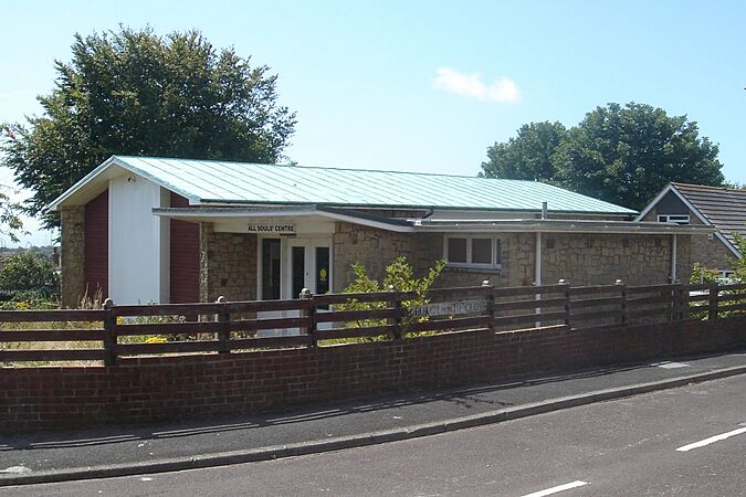
All Souls Centre in Southwick was a multipurpose building dating from 1955.
-
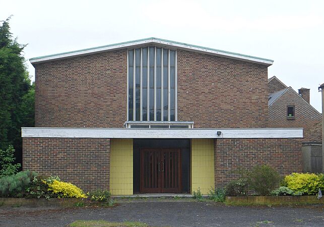
The Second Church of Christ, Scientist, Worthing opened in 1960.
-
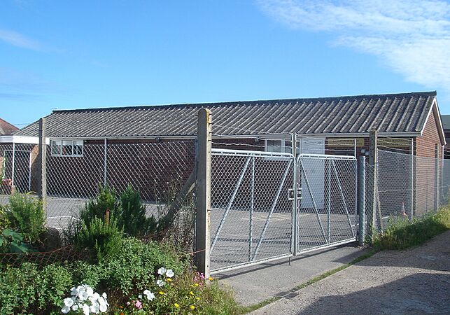
Lancing's original Kingdom Hall was in use between 1960 and 2011.
-
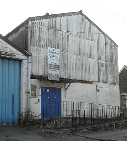
This building in the West Green area of Crawley was used as a Hindu temple until 2010.
-
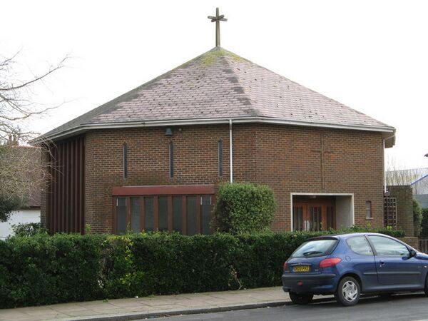
Emmanuel Church in Worthing opened in 1977 and was demolished in 2008.
-
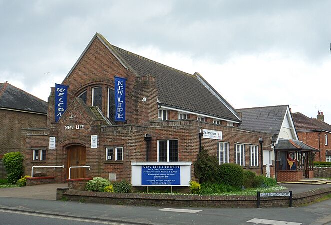
New Life Church at Durrington was demolished in 2022. It is moving to a new site.
-
St Luke's Church served the Stone Quarry area of East Grinstead between 1954 and 2014. It was demolished the following year.
-
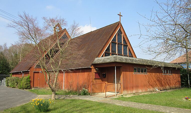
The Church of the Good Shepherd, Franklands Village, stood between 1964 and 2016.
-
St Michael and All Angels Church in the West Meads area of Aldwick was built in 1968.
-
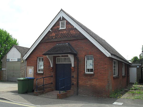
The former Primitive Methodist mission room in Rushams Road, Horsham, was in religious use only for a short time but survived until 2018.

_(2).JPG)
_(3).JPG)
_(2).JPG)

_(5).JPG)

_(2).JPG)


See also
- List of demolished places of worship in Brighton and Hove
- List of demolished places of worship in East Sussex
