Little Clifton facts for kids
Quick facts for kids Little Clifton |
|
|---|---|
| Population | 480 (2011) |
| OS grid reference | NY0553 528651 |
| Civil parish |
|
| District | |
| Shire county | |
| Region | |
| Country | England |
| Sovereign state | United Kingdom |
| Post town | Workington |
| Postcode district | CA14 |
| Dialling code | 01900 |
| Police | Cumbria |
| Fire | Cumbria |
| Ambulance | North West |
| EU Parliament | North West England |
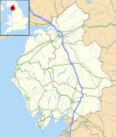
Little Clifton is a small village in Cumbria, England. It is located near the beautiful Lake District. In 2011, about 480 people lived here in 207 homes.
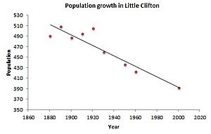
The village is about 3.5 kilometers (2.2 miles) east of Workington. The River Derwent flows about 1 kilometer (0.6 miles) north of Little Clifton. In 1887, a writer named John Bartholomew described Little Clifton as a small area with 489 people, close to Workington.
Contents
How Little Clifton is Governed
Little Clifton is part of the Workington area for the UK Parliament. This is where laws are made for the whole country. The person who represents Workington in Parliament is called a Member of Parliament (MP).
The current MP for Workington is Sue Hayman from the Labour Party. The Labour Party has won this area in most elections since 1979.
For local matters, Little Clifton is part of the Stainburn + Clifton Ward. This ward is managed by Allerdale Borough Council. It is also part of the Cockermouth South Division of Cumbria County Council.
Little Clifton also has its own local council, called the Little Clifton Parish Council. This council looks after local village issues.
History of Little Clifton's Name and Area
Cumbria is a county made up of older areas like Cumberland and Westmorland. People have lived here for a very long time, possibly as far back as 5,000 years ago. Evidence like stone circles has been found nearby. These early people used the area to find stones for making tools.
Around 500 BC, a group called the Celts came to the area. They were known as the Brigantes in Cumbria. The Brigantes had a big settlement in Carlisle. After the Romans left around 350-420 AD, the Celts continued to thrive.
Later, the Anglo Saxons arrived. Around 630 AD, they took over the area and it became part of their powerful kingdom called Northumbria. The name Little Clifton comes from the Anglo-Saxons. The word 'ton' in Clifton means an 'enclosure', 'estate', or 'homestead' in Old English.
Mining in the Area
Mining has been a very important part of Cumbria's history. People have mined for many different materials like lead, copper, zinc, and coal since the 12th century. The western parts of Cumbria, especially near Whitehaven, had large amounts of haematite (iron ore) close to the surface.
The first recorded mining in Cumbria was at Bigrigg mine. This mine is about 24 kilometers (15 miles) south of Little Clifton. It is thought that the Romans, and later early British and Norse settlers, also mined here.
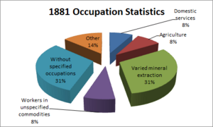
In 1881, a large number of people in Little Clifton worked in mining. About 31% of the villagers were involved in getting minerals from the ground. This was the most common job in the village at that time. Force Crag mine, near Keswick, was the closest mine to Little Clifton. It mined for lead, zinc, and barytes from 1839 until it closed in 1991. Today, the National Trust looks after Force Crag mine, and you can visit it.
St Luke's Church
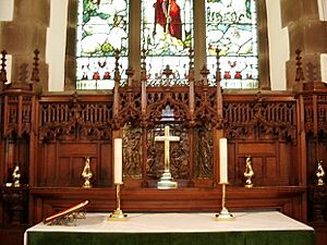
St Luke's Church has a very old history, going back to Norman times. You can still see some Norman features there, like an old archway and a cross in the churchyard. The church building you see today was built in 1901.
Inside, it has beautiful stained glass windows and other decorations. These were given by local families. The church often hosts concerts and open days for the community.
Punderland Farm
Punderland Farm is the only building in Little Clifton that is a listed building. This means it is a special building that is protected because of its history or architecture. The farmhouse was built in 1739. It has two floors and a green slate roof. There is also a barn connected to the farmhouse.
The farm was once in the news because of a sad mistake. During a health outbreak in 2001, a mix-up with map coordinates led to animals being removed from Punderland Farm by accident. The farm that was meant to be affected was actually 160 kilometers (100 miles) away. The farm received standard compensation for the loss.
 | Jessica Watkins |
 | Robert Henry Lawrence Jr. |
 | Mae Jemison |
 | Sian Proctor |
 | Guion Bluford |


