
Little Wapwallopen Creek facts for kids
Quick facts for kids Little Wapwallopen Creek |
|
|---|---|

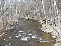
Little Wapwallopen Creek looking downstream from Ruckle Hill Road
|
|
| Physical characteristics | |
| Main source | Boyle Pond in Rice Township, Luzerne County, Pennsylvania 1,220 ft (370 m) |
| River mouth | Susquehanna River in Conyngham Township, Luzerne County, Pennsylvania 495 ft (151 m) |
| Length | 17 mi (27 km) |
| Basin features | |
| Progression | Susquehanna River → Chesapeake Bay |
| Basin size | 39.5 sq mi (102 km2) |
| Tributaries |
|
Little Wapwallopen Creek is a tributary (a smaller stream that flows into a larger one) of the Susquehanna River in Luzerne County, Pennsylvania. It's about 17 miles (27 km) long. The creek flows through several towns, including Rice Township, Dorrance Township, and Conyngham Township.
The area of land that drains into the creek, called its watershed, covers about 39.5 square miles (102 km2). Little Wapwallopen Creek is known as a good place for coldwater fish and is also important for fish that travel to different waters (migratory fish). It's considered a healthy creek, and wild trout live and reproduce there naturally. The creek has two main smaller streams that flow into it: Pond Creek and Nuangola Outlet.
Contents
The Creek's Journey

Little Wapwallopen Creek starts its journey in Boyle Pond in Rice Township. From there, it flows west, passing through another pond. It then turns south-southwest for a while before heading west again.
Along its path, the creek meets Nuangola Outlet, which is its first named tributary. The creek continues its winding journey, crossing Interstate 81 and entering Dorrance Township. It also flows through Andy Pond and changes direction many times, heading west, then north, and then west again.
Eventually, the creek flows into Conyngham Township. It briefly enters Hollenback Township before returning to Conyngham Township, flowing alongside Hess Mountain. As it gets closer to its end, the valley around the creek gets wider. It then receives another tributary called Pond Creek and crosses Pennsylvania Route 239. A short distance later, Little Wapwallopen Creek joins the much larger Susquehanna River.
Creek Branches and Water Flow
Little Wapwallopen Creek has many small, unnamed streams that flow into it, plus two named ones: Nuangola Outlet and Pond Creek. These tributaries add water to the main creek.
- Pond Creek joins Little Wapwallopen Creek about 1.52 miles (2.45 km) before it reaches the Susquehanna River. The area that drains into Pond Creek is about 9.69 square miles (25.1 km2).
- Nuangola Outlet flows into Little Wapwallopen Creek about 14.55 miles (23.42 km) from its mouth. Its watershed covers about 2.35 square miles (6.1 km2).
Water Quality and Flooding
The amount of water flowing in Little Wapwallopen Creek, called its discharge, can change a lot, from very little to a lot, depending on the weather. The water in the creek is generally clear.
The creek's pH level, which tells us if water is acidic or basic, usually ranges from slightly acidic to slightly basic. This balance is good for the plants and animals living in the water. Importantly, the creek is considered healthy and not polluted.
The amount of dissolved oxygen in the creek's water is also good. This oxygen is very important for fish and other aquatic creatures to breathe and survive.
Little Wapwallopen Creek can sometimes cause flooding in areas like Conyngham Township, Dorrance Township, and Rice Township. This happens when there's a lot of rain, and the creek overflows its banks. Large floods can cover significant areas of land, especially where the land is flat.
Land and Surroundings

The creek starts high up, about 1,220 feet (370 m) above sea level, and flows down to about 495 feet (151 m) at its mouth where it meets the Susquehanna River. The creek's path is quite winding and curvy.
The land around Little Wapwallopen Creek has different types of soil and rocks. You can find alluvium, which is made of sand, silt, and gravel carried by the water. There are also areas with alluvial terraces, which are flat areas formed by old floodwaters. Some parts of the valley also show signs of glaciers from the past, like Wisconsinan Ice-Contact Stratified Drift.
The land in the creek's floodplain (the flat area next to the creek that can flood) is mostly used for farming and forests. However, some homes are also located there.
Lakes and Ponds in the Watershed

Many lakes and ponds are part of the Little Wapwallopen Creek watershed. These include:
- Lilly Lake, a 160-acre (65 ha) lake that feeds into one of the creek's tributaries.
- Triangle Pond, located in the upper parts of the watershed.
- Round Pond and Turner Swamp, also mentioned historically as being in the watershed.
- Other nearby lakes and ponds like Andy Pond, Lake Blytheburn, Boyle Pond, Nuangola Lake, and the Ice Ponds.
Many wetlands, which are important habitats for wildlife, are found in the upper parts of the watershed.
History of the Creek
Little Wapwallopen Creek was officially added to the Geographic Names Information System in 1979, which helps keep track of geographic names in the United States.
Long ago, Native Americans used a path that followed the Little Wapwallopen Creek valley to travel between Council Cup and Wilkes-Barre. The first European settler in Conyngham Township, Martin Harter, settled near the creek's mouth in 1795.
Over the years, many bridges have been built across Little Wapwallopen Creek to help people travel. Some of the older bridges date back to the 1920s and 1930s. Newer bridges, including those for Interstate 81, were built in the 1960s and later.
In the early 1900s, companies even built dams on streams in the creek's watershed to create ponds for harvesting ice, like the Ice Ponds.
The creek has a special group called the Little Wapwallopen Creek Watershed Association. This group works to protect and improve the creek and its surroundings. In 2002, a project began to help restore the upper parts of the creek, and since 2005, efforts to fix streambank erosion have been successful.
Creek Life
The Little Wapwallopen Creek is a great place for fish. It's designated as a Coldwater Fishery, meaning its waters are cool enough for fish like trout. It's also a Migratory Fishery, important for fish that travel between different water bodies.
Wild trout naturally reproduce in the creek, especially from its mouth upstream for about 4.40 miles (7.08 km). They also reproduce in its tributary, Pond Creek. Historically, other ponds in the watershed, like Long Pond and Round Pond, were known to have many fish. In the early 1900s, young brook trout were even added to the creek to help boost the fish population.
The area around Little Wapwallopen Creek is considered important for conservation. There's a plan to create a "greenway" along the creek, which would be a protected natural area for wildlife and outdoor activities.
Images for kids
-
Little Wapwallopen Creek looking downstream from Ruckle Hill Road
