Loch na Keal facts for kids
Quick facts for kids Loch na Keal |
|
|---|---|

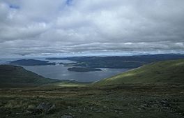
View of the loch from Ben More
|
|
| Location | Isle of Mull, Argyll and Bute, Scotland |
| Coordinates | 56°28′N 6°05′W / 56.467°N 6.083°W |
| Type | Sea loch |
| Basin countries | Scotland, United Kingdom |
| Max. length | 23 km (14 mi) |
| Max. width | 20 km (12 mi) |
| Surface area | 442 km2 (171 sq mi) |
| Average depth | 38 m (124 ft) |
| Max. depth | 112 m (366 ft) |
| Islands | Many: Ulva is the largest |
Loch na Keal (which means "Loch of the Narrows" or "Loch of the Cliffs") is a large sea loch on the western coast of the Isle of Mull in Scotland. It's part of the Inner Hebrides islands.
This loch stretches about 20 kilometers (12 miles) inland. It almost cuts the Isle of Mull in half! Loch na Keal is so special that it gives its name to the Loch na Keal National Scenic Area. This is one of forty such areas in Scotland, chosen for their amazing natural beauty.
Contents
What is Loch na Keal Like?
Loch na Keal has two main parts. The outer part is wide and shaped like a triangle. The inner part is much narrower.
Islands in the Loch
Several islands are found in or near Loch na Keal. These include Staffa, Inch Kenneth, and Eorsa. The larger islands of Gometra and Ulva separate the loch from Loch Tuath to the north.
The Coastline Around the Loch
The northern coast of the outer loch, on Ulva, has rocky ridges made of basalt. You'll see many small rocks and islets there, with lots of different plants.
The southern coast is part of the Ardmeanach peninsula. Here, you'll find tall cliffs and steep slopes covered in loose rocks called scree.
The inner loch's northern shore has gentle hills and a forest called Killiechronan Wood. The southern shore has cliffs and slopes leading up to Ben More. This is a large mountain and an extinct volcano.
Towns and Roads Nearby
There are no big towns right on Loch na Keal. Most small settlements are at the eastern end of the loch. This is where the River Bà flows into the loch from Loch Bà.
One small village is Gruline, which has farms and homes for tourists. The closest larger village is Salen, about 4 kilometers (2.5 miles) northeast across a narrow strip of land.
Two main roads follow the loch's shores. The B8073 road runs along the northern side. The B8035 road follows the southern shore before heading inland.
Exploring the Islands of Loch na Keal
Many islands are found within Loch na Keal. They range in size from the large island of Ulva to tiny rocks.
Ulva: The Largest Island
Ulva is the biggest island on Mull's west coast. It is connected to the nearby island of Gometra by a bridge. Much of Ulva is made of basalt rock, which sometimes forms cool columns.
People have lived on Ulva for thousands of years, since the Stone Age. The Vikings gave the island its name, which probably means "wolf island." Later, Scottish Gaelic became the main language.
In the 1800s, many people were forced to leave the island during the "Highland Clearances." At one time, over 800 people lived here, but now there are fewer than 10.
Ulva is full of wildlife! You can often see whales and dolphins in the water. Over 500 types of plants grow on the island. Today, a ferry service helps tourists visit, and tourism is important for the island's economy.
Gometra: A Farming Island
Gometra is just west of Ulva and is connected to it by a bridge. At low tide, you can even walk between them on a beach. Gometra is about 425 hectares (1.6 square miles) in size.
This island is mainly used for farming. It used to grow grain for the monastery on Iona. Gometra once had over a hundred people living there. Now, only a few people live there, along with many sheep, cattle, pigs, horses, and wild goats and deer.
Gometra has old burial grounds and ancient settlements. It doesn't have a school, doctor, or ferry. It does get mail once a week and even has its own local stamps!
Little Colonsay: Uninhabited Island
Little Colonsay is an uninhabited island south of Ulva and Gometra. It has interesting basalt rock formations, similar to Staffa.
In the 1800s, a few people lived on Little Colonsay, but they were later forced to leave. In the early 1900s, a farmer named John MacColum lived there, but he and his family had to leave because of too many rats!
Staffa: Home of Fingal's Cave
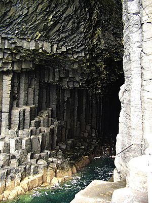
Staffa is about 10 kilometers (6 miles) west of Mull. Its name comes from an Old Norse word meaning "stave" or "pillar island." The Vikings named it this because its basalt columns looked like the vertical logs used to build their houses.
Staffa became famous in the late 1700s after a visit by Sir Joseph Banks. He and his friends were amazed by the natural beauty of the basalt columns and the island's main sea cave. Banks renamed this cave "Fingal’s Cave".
Many famous people visited Staffa after that, including Queen Victoria and the composer Felix Mendelssohn. Mendelssohn's music, the Hebrides Overture, made the island even more famous. Staffa is now looked after by the National Trust for Scotland.
Inch Kenneth: A Historic Island
Inchkenneth is a small, grassy island at the entrance of Loch na Keal, south of Ulva. It's named after Saint Kenneth, who is believed to have started a monastery there.
In 1773, the famous writers Samuel Johnson and James Boswell visited Inch Kenneth during their trip to the Hebrides. They were hosted by Sir Allan MacLean, the head of the Maclean clan.
Later, the island was owned by the famous and sometimes controversial Mitford family. After their father passed away, the island was inherited by his daughters. One of them, Jessica, who was a former communist, jokingly suggested it could become a Soviet submarine base!
Eorsa: A Fictional Setting
Eorsa is an uninhabited island east of Ulva. It once belonged to the Iona Abbey and later to the Duke of Argyll.
The island is the fictional setting for Nigel Tranter's 1952 novel Bridal Path. This funny book was even made into a movie in 1959. The story is about the challenges of island life, and Tranter likely chose an empty island to avoid upsetting anyone.
Treshnish Islands: Volcanic Archipelago
The Treshnish Isles are a group of small islands and rocks that lie just outside the mouth of Loch na Keal. They are part of the National Scenic Area. This group of islands stretches for about 7 kilometers (4 miles).
The largest island in this group is Lunga. Other larger islands include Cairn na Burgh Mòr, Fladda, and Bac Mòr. All these islands were formed by volcanoes.
Nature and Conservation Around Loch na Keal
| Loch na Keal National Scenic Area | |
|---|---|
|
IUCN Category V (Protected Landscape/Seascape)
|
|

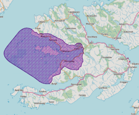
The extent of the Loch na Keal National Scenic Area
|
|
| Location | Isle of Mull, Argyll and Bute, Scotland |
| Area | 443 km2 (171 sq mi) |
| Established | 1981 |
| Governing body | NatureScot |
The Loch na Keal National Scenic Area is one of Scotland's special places. These areas are chosen because they have amazing scenery that needs to be protected from harmful development.
This protected area covers a huge space, about 44,250 hectares (171 square miles). This includes both land and the sea around the loch. It covers the shores of the loch and islands like Staffa, Ulva, Gometra, and the Treshnish Isles.
Protecting Wildlife
The land on the southern side of the loch is a "Special Protection Area." This is very important for golden eagles. These magnificent birds have been breeding here for a long time. The golden eagles in this area have more chicks than other groups in western Scotland. This means it's one of the best places in the UK to find these birds!
The outer waters of the loch are also protected as a "Special Area of Conservation." This is because harbour porpoises live there.
Burg Estate and Ancient History
The Burg estate is a large area of land on the tip of the Ardmeanach peninsula, on the southern side of the loch. The National Trust for Scotland has owned it since 1932.
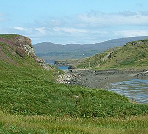
At Burg, you can see a fossil of a tree that is 50 million years old! It's called MacCulloch’s Fossil Tree. This area also has ancient burial mounds from the Bronze Age. You can also find the remains of an Iron Age settlement and old farming villages.
 | Janet Taylor Pickett |
 | Synthia Saint James |
 | Howardena Pindell |
 | Faith Ringgold |


