
Treshnish Isles facts for kids
| Gaelic name | Eileanan Treisinis |
|---|---|
| Meaning of name | unknown |
| OS grid reference | NM278419 |
| Coordinates | 56°29′N 6°25′W / 56.49°N 6.42°W |
| Physical geography | |
| Island group | Mull |
| Area | 128 ha (316 acres) |
| Highest elevation | Cruachan, on Lunga 103 m (338 ft) |
| Administration | |
| Sovereign state | United Kingdom |
| Country | Scotland |
| Council area | Argyll and Bute |
| Demographics | |
| Population | 0 |
The Treshnish Isles are a group of small islands and rocky outcrops located off the west coast of Scotland. They are found near the Isle of Mull and are part of the Inner Hebrides. These beautiful islands are a popular spot for visitors, especially during the summer months. You can take boat trips to the Treshnish Isles from places like Ulva Ferry, Tobermory, Ardnamurchan, and Tiree.
Contents
Geography of the Treshnish Isles
The Treshnish Isles stretch out for about 7 kilometers (4.3 miles). They go from the island of Bac Beag in the south to the north-east.
The biggest island in the group is Lunga. It is about 7 kilometers (4.3 miles) west of Gometra. It's also 6 kilometers (3.7 miles) south-west of the Isle of Mull. Other islands like Coll and Staffa are also nearby.
Other fairly large islands in this group include Cairn na Burgh Mòr, Fladda, and Bac Mòr. There are also many smaller rocky islands, especially north of Lunga. All the islands in the Treshnish group were formed by volcanoes.
Main Islands of the Treshnish Group
Here's a quick look at some of the islands in the Treshnish group:
- Bac Beag: Its Gaelic name is Am Baca Beag. It covers about 6.7 hectares and its highest point is 27 meters (89 feet).
- Bac Mòr: Its Gaelic name is Am Baca Mòr. It covers about 24.7 hectares and its highest point is 86 meters (282 feet).
- Lunga: Its Gaelic name is Lunga. It covers about 59.9 hectares and its highest point is 103 meters (338 feet).
- Sgeir a' Chaisteil: Its Gaelic name is Sgeir a' Chaisteil. It covers about 3.7 hectares and its highest point is 26 meters (85 feet).
- Sgeir an Eirionnaich: Its Gaelic name is Sgeir an Eirionnaich. It covers about 5 hectares and its highest point is 15 meters (49 feet).
- Fladda: Its Gaelic name is Flada. It covers about 20.6 hectares and its highest point is 26 meters (85 feet).
- Cairn na Burgh Mòr: Its Gaelic name is Cairn Bhuirg Mòr. It covers about 3.6 hectares and its highest point is 35 meters (115 feet).
- Cairn na Burgh Beag: Its Gaelic name is Cairn Bhuirg Beag. It covers about 2.2 hectares and its highest point is 22 meters (72 feet).
History of the Treshnish Isles
The Treshnish Isles have a long history. There are signs of ancient forts, called duns, from the Iron Age. This was a time when people used iron tools and weapons. Not much is known about the very early history of the islands. However, these islands were important landmarks for the Norse settlers. The Norse people came to Scotland during the early years of the Kingdom of the Isles. This kingdom lasted from the 9th to the 13th centuries.
On the island of Lunga, you can still see the remains of a village. This village was made up of traditional Scottish houses called blackhouses. The last people left this village in 1857.
In 1938, a famous explorer and naturalist named Colonel Niall Rankin bought the Treshnish Isles. Later, in 2000, the islands were sold to the Hebridean Trust. This trust now looks after the islands. Their job is to protect the islands and their wildlife. They also study the nature and old ruins found there.
The Treshnish Isles are very popular with tourists. People love to visit because the islands are beautiful and peaceful. They also come to see the amazing wildlife, especially the many puffins. Many visitors take day-trips by boat to Lunga during the summer.
Meaning of the Treshnish Island Names
The name Treisinis is a Gaelic name. Its exact meaning is not known. However, it includes an old Norse word, ness, which means "headland" or a piece of land sticking out into the sea.
Some islands have interesting English names based on their shape:
- Bac Mòr is also known as "The Dutchman's Cap" in English. This is because its shape looks like a traditional hat.
- Bac Beag comes from the Gaelic words Am Baca Beag. Bac means "bank" or "dune". Beag means "small", while Mòr means "large". So, Bac Beag is the "small bank" compared to Bac Mòr, the "large bank". Bac Mòr is also called Baca Rois in Gaelic. This means "dune of the Ross" and refers to how the island looks when seen against the Ross of Mull.
- Lunga likely comes from the Old Norse words lungr-øy. This means "longship island".
- Sgeir an Eirionnaich is a Gaelic name meaning "Irishman's skerry". A skerry is a small rocky island.
- Sgeir a' Chaisteil is a Gaelic name meaning "castle skerry".
- Cairn na Burgh Mòr means "cairn of the large fort". A cairn is a pile of stones.
- Cairn na Burgh Beag means "cairn of the small fort".
- Fladda gets its name from an Old Norse word meaning "flat island".
Nature and Conservation on the Treshnish Isles
The Treshnish Isles are a very important natural area. They are part of the Loch Na Keal National Scenic Area. This is one of 40 such special areas in Scotland.
The islands are also protected in other ways:
- They are a Site of Special Scientific Interest. This means they have special plants, animals, or geology.
- They are a Special Protection Area because they are very important for seabirds that come there to breed.
- They are also a marine Special Area of Conservation. This protects the sea around the islands.
Besides seabirds, the Treshnish Isles are known for their Atlantic grey seals. You can often see these seals resting on the rocks. The islands also have old ruined castles, adding to their wild beauty.
See also
 In Spanish: Islas Treshnish para niños
Images for kids
-
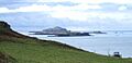
The Treshnish Isles from above Port Haunn on Mull. Nearest are Cairn na Burgh Beag and Cairn na Burgh Mòr. Behind are the low flat island of Fladda and the tallest island, Lunga, which obscures Bac Mòr and Bac Beag beyond.
-
The Treshnish Isles from the east as seen from Loch Tuath. From left to right: (Ellean Dioghlum), Bac Mòr, Lunga, Fladda, Cairn na Burgh Mòr, Cairn na Burgh Beag.


