
Gometra facts for kids
| Gaelic name | Gòmastra |
|---|---|
| Norse name | Goðrmaðrey |
| Meaning of name | Possibly Good-man's island |
| OS grid reference | NM361414 |
| Coordinates | 56°29′N 6°17′W / 56.49°N 6.29°W |
| Physical geography | |
| Island group | Mull |
| Area | 425 ha (1.64 sq mi) |
| Area rank | 75 |
| Highest elevation | 155 m (509 ft) |
| Administration | |
| Sovereign state | United Kingdom |
| Country | Scotland |
| Council area | Argyll and Bute |
| Demographics | |
| Population | 2 |
| Population density | 0.5/km2 (1.3/sq mi) |
| Gometra | |
|---|---|
| Highest point | |
| Elevation | 155 m (509 ft) |
| Prominence | 155 m (509 ft) |
| Listing | Marilyn |
| Geography | |
| Location | Off the coast of Mull, Scotland |
| Topo map | OS Landrangers 47, 48 |
Gometra (which in Gaelic is Gòmastra) is a small island in Scotland. It is part of the Inner Hebrides group of islands. Gometra is located just west of the larger island of Mull. It is also very close to the island of Ulva, and you can even walk between Gometra and Ulva at low tide across a beach. There is also a bridge connecting the two islands. Gometra is about 425 hectares (or 1.6 square miles) in size. The highest point on the island is also called Gometra, and it is a type of hill known as a Marilyn.
Contents
What Does the Name Gometra Mean?
The name Gometra comes from an old language called Norse. Experts believe it might mean "The good-man's island" or "God-man's island." Another idea is that it means "Godmund's island." Some people also think the Norse name Goðrmaðray could mean "warrior priest's island."
There's also a Gaelic idea for the name. Gu mòr traigh means "only at low tide." However, this might just be a folk story about the name. In old documents from the Middle Ages, the island's name was written as "Gomedrach."
What is Gometra Made Of?
Gometra, like many nearby islands such as Mull and Ulva, is mostly made of basalt lava. This lava came from volcanoes that erupted a very long time ago. These eruptions happened during a period called the early Palaeogene.
You can also find some dykes on the island. These are like walls of rock that cut through the basalt. They are younger than the lava and run from northwest to southeast.
Life and Nature on Gometra

Gometra has a history of farming. Long ago, farmers grew grain there for the monastery on Iona. Today, only a few people live on Gometra. However, there are many animals! You can find up to a thousand black face sheep, Highland cattle, pigs, horses, and even wild goats. There are also red deer on the island.
Gometra is a quiet place. It does not have a school, a doctor, or a ferry service directly to the mainland. It does have a weekly postal service. The island even prints its own special stamps for local mail!
The island is part of the Loch Na Keal National Scenic Area. This is one of 40 special areas in Scotland known for their beautiful landscapes.
Gometra's Past: A Brief History
Over time, Gometra has been part of different kingdoms and owned by various groups.
Early Ownership and Norse Influence
During the time of the Norse people, Gometra became part of the Kingdom of the Isles. While nearby Ulva and Staffa were owned by the MacQuarries from the 900s, Gometra belonged to the Iona monastery. Later, it became a possession of the Duke of Argyll.
An old book from 1549, A Description of the Western Isles of Scotland, does not mention Gometra. But another writer in 1612, John Monipennie, briefly talks about it. He said Gometra was "about 300 paces from this island [Ulva], two miles long and one mile broad."
Changes in Ownership and Population
In 1821, Ulva was sold to Lt-General Charles MacQuarrie. After he passed away, a lawyer named Francis William Clark bought Ulva in 1835. He began to move many people off Ulva. However, the MacDonalds of Staffa kept Gometra until 1858. Then, Donald MacLean bought it and built Gometra House.
In 1932, a famous English mountaineer named Hugh Ruttledge bought the island. He had retired early and wanted to be a farmer. While living on Gometra, Ruttledge led two British trips to Mount Everest in the 1930s. He also learned to sail. In 1950, he moved away from the island.
Gometra House became very run down by the 1980s. But in the 1990s, it was fixed up and became a family home again. Today, a millionaire and environmental supporter named Roc Sandford owns the island. He bought it in 1991. He lives "off grid" on Gometra for part of the year and in London for the rest.
In 2012, some people living on the island were worried. A company planned to build a large fish farm nearby, which could affect the environment.
Getting Around Gometra
Traveling on Gometra can be an adventure! If you are at the houses on the west side of Gometra, it takes about 1 hour and 15 minutes to reach the ferry on Ulva by a special 4x4 vehicle. From there, you can take a ferry to Mull. If you use a quad bike, the same trip takes only 50 minutes. If you travel by boat from Acarseid Mhòr, it's a quick 20-minute journey.
Images for kids
-
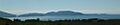
The north coast of Gometra as seen from Mull.
See also
 In Spanish: Gometra para niños
