
Louisiana Purchase Historic State Park facts for kids
Quick facts for kids Louisiana Purchase Historic State Park |
|
|---|---|
 |
|
| Location | Arkansas, United States |
| Nearest city | Brinkley |
| Area | 37.5 acres (15.2 ha) |
| Established | 1961 |
| Governing body | Arkansas Department of Parks, Heritage, and Tourism |
| Website | Official website: http://www.arkansasstateparks.com/louisianapurchase |
| Designated | February 23, 1972 |
| Lua error in Module:Location_map at line 420: attempt to index field 'wikibase' (a nil value). | |
The Louisiana Purchase Historic State Park is a special place in Arkansas. It marks the exact spot where surveyors began mapping the huge amount of land the United States bought from France. This big land deal was called the Louisiana Purchase.
The park protects about 37.5 acres (15.2 ha) of beautiful, wild wetlands. These are like swamps with many trees. This type of land is becoming rare because many wetlands are drained to create farmland. At the survey spot, there is a 6-foot (1.8 m) stone marker. It was put there in 1926 by a group called the Daughters of the American Revolution. This park is so important that it is listed on the U.S. National Register of Historic Places and is a National Historic Landmark.
Contents
What is the Louisiana Purchase Park?
This historic state park is in eastern Arkansas. You can find it at the end of Highway 362, southeast of Blackton, Arkansas. It sits where three counties meet: Lee, Monroe, and Phillips.
The park's 37.5-acre (15.2 ha) of swampy, forested wetlands looks almost exactly as it did in 1815. This is when the first surveyors arrived. These kinds of wetlands are very rare now. This is because people often drain and clear them for farming.
A long boardwalk, about 950 feet (290 m) in length, leads visitors to the survey marker. Along the way, you will see signs. These signs explain the plants and animals of the area. They also tell you why this landmark is so important.
The Survey Marker
The Louisiana Purchase Survey Marker is 6 feet (1.8 m) tall. It is about 4.5 feet (1.4 m) wide at its base. Usually, it stands in about 1 foot (0.30 m) of swamp water.
The words carved on the marker say:
"This stone marks the base established November 10, 1815, from which the lands of the Louisiana Purchase were surveyed by United States engineers. The first survey from this point was made to satisfy the claims of the soldiers of the War of 1812 with land bounties".
This means it was the starting point for mapping the land. This mapping helped give land to soldiers who fought in the War of 1812.
History of the Louisiana Purchase
On April 30, 1803, the United States bought a huge amount of land from France. This deal was called the Louisiana Purchase. It added about 830,000 square miles (2,100,000 km2) of land west of the Mississippi River. This purchase actually doubled the size of the United States!
President Thomas Jefferson then sent out the Lewis and Clark Expedition. From 1804 to 1806, they explored this new territory. They traveled west along the Missouri River and other rivers, eventually reaching the Pacific Coast.
Mapping the New Land
In 1815, President James Monroe ordered a survey of the new territory. A survey means carefully measuring and mapping land. This was done so that land could be given to soldiers who fought in the War of 1812. These land gifts were called "land bounties."
Two men, Prospect K. Robbins and Joseph C. Brown, were chosen to find a starting point for this survey. This point is in what is now eastern Arkansas. Robbins' team traveled north from the mouth of the Arkansas River. Brown's team traveled west from the mouth of the St. Francis River.
On October 27, 1815, Robbins' group crossed the line that Brown's group had marked. This meeting point officially became the Fifth Principal Meridian. This was the main starting line for all the surveys.
Robbins' team traveled 55 miles (89 km) through very difficult land. Brown's team traveled 26 miles (42 km) through land that was sometimes good for farming and sometimes full of thick bushes. Brown's team surveyed as far west as present-day Little Rock. Robbins continued north to the Missouri River. To mark their meeting spot, they carved marks into two nearby trees.
Rediscovering the Spot
Even though survey work continued for many years, the original starting point was forgotten. It was used to map most of Arkansas, Missouri, Minnesota, Iowa, and North and South Dakota.
In 1921, surveyors working between Phillips and Lee counties found the marked trees. They had rediscovered the forgotten spot! The Marianna, Arkansas chapter of the Daughters of the American Revolution started a project to honor this place. They raised money to put the stone marker there. A special ceremony was held on October 27, 1926. This was 111 years after the survey point was first established.
At the dedication ceremony, four local landowners each gave 2 acres (0.81 ha) of their land around the point. This would have created an eight-acre park. In 1961, Arkansas officially made the area a state park. However, no money was given to buy the land or develop the park at first.
Later, the Arkansas Natural Heritage Commission recognized how important the swamp was. They provided money to buy the 37.5 acres (15.2 ha) that now make up the park. The Commission also has a special agreement to protect the land. This agreement makes sure that the park's natural state is preserved and limits any future building.
Gallery
-
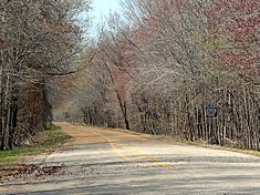
Entrance to the park on State Highway 362.
-
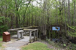
Footpath leading to the boardwalk.
-
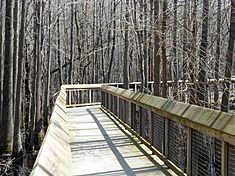
Boardwalk leading to the site.
-
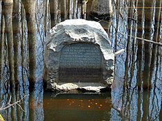
Monument to the Louisiana Purchase Survey.


