
Madawaska, Maine facts for kids
Quick facts for kids
Madawaska, Maine
Ville de Madawaska (French)
|
|||
|---|---|---|---|
 |
|||
|
|||

Location of Madawaska, Maine
|
|||

Madawaska, Maine
Location in Maine

Madawaska, Maine
Location in the United States
|
|||
| Country | United States | ||
| State | Maine | ||
| County | Aroostook | ||
| Incorporated | 1869 | ||
| Villages | Madawaska Cleveland Fournier Lavertue St. David |
||
| Area | |||
| • Total | 56.24 sq mi (145.66 km2) | ||
| • Land | 55.56 sq mi (143.90 km2) | ||
| • Water | 0.68 sq mi (1.76 km2) | ||
| Elevation | 971 ft (296 m) | ||
| Population
(2020)
|
|||
| • Total | 3,867 | ||
| • Density | 70/sq mi (26.9/km2) | ||
| Time zone | UTC-5 (Eastern (EST)) | ||
| • Summer (DST) | UTC-4 (EDT) | ||
| ZIP Codes |
04756 (Madawaska)
04773 (St. David) |
||
| Area code(s) | 207 | ||
| FIPS code | 23-42520 | ||
| GNIS feature ID | 0582576 | ||


Madawaska is a town located in Aroostook County, Maine, in the United States. In 2020, about 3,867 people lived there. Madawaska is right across the Saint John River from Edmundston, Canada. The two towns are connected by a bridge. Most people in Madawaska speak French, with over 83% speaking it at home.
Contents
History of Madawaska
In the past, Madawaska was an important meeting and hunting area for the Maliseet (Wolastoqiyik) people. Later, it became famous for a peaceful disagreement called the Aroostook War. This "war" was about where the border between the United States and British Canada should be.
Settling the Border Dispute
The border was finally decided in 1842 with the Webster-Ashburton Treaty. This treaty gave most of the disputed land to Maine. It also gave the British a key connection between their provinces of Quebec and New Brunswick. Because of this new border, many families found themselves split between two different countries.
Economy and Industry
Madawaska is a rural town, meaning it's mostly countryside. Its economy mainly depends on the paper industry along the Saint John River.
Paper Mills and Trade
Historically, the river helped power the mills. It also carried logs from forests upstream to the mills. Today, the river still provides water for making paper. However, logs are now brought by highway and rail to protect the environment.
A Canadian company called Twin Rivers has a big paper facility in Madawaska. This plant processes wood pulp that comes from another Twin Rivers mill in Edmundston, Canada. The pulp travels through a long pipeline under the river to Madawaska. Here, it is made into special fine-grade papers.
Madawaska's economy relies a lot on trade with Canada. Many people see Madawaska and Edmundston as one big economic area.
Local News
The town is also home to the St. John Valley Times. This is a popular weekly newspaper that is read across Aroostook County.
Geography of Madawaska
Madawaska covers about 56.24 square miles (145.66 square kilometers). Most of this area is land, with a small part being water. The town is located right next to the Saint John River, which forms part of the Canada–United States border.
Four Corners Park
Madawaska is special because it's home to Four Corners Park. This park marks the most northeastern town in the mainland United States. U.S. Route 1, a major highway, also runs through the town.
Climate in Madawaska
Madawaska has a climate with big changes in temperature throughout the year. Summers can be warm to hot and often humid. Winters are cold, sometimes very cold. This type of weather is known as a humid continental climate.
| Climate data for Edmundston, Canada (adjacent to Madawaska) | |||||||||||||
|---|---|---|---|---|---|---|---|---|---|---|---|---|---|
| Month | Jan | Feb | Mar | Apr | May | Jun | Jul | Aug | Sep | Oct | Nov | Dec | Year |
| Record high °F (°C) | 55.4 (13.0) |
57.2 (14.0) |
72.5 (22.5) |
82.4 (28.0) |
94.1 (34.5) |
93.2 (34.0) |
96.8 (36.0) |
94.1 (34.5) |
90.5 (32.5) |
84.2 (29.0) |
67.1 (19.5) |
52.7 (11.5) |
96.8 (36.0) |
| Mean daily maximum °F (°C) | 19.2 (−7.1) |
23.2 (−4.9) |
34.0 (1.1) |
47.5 (8.6) |
62.8 (17.1) |
71.6 (22.0) |
76.5 (24.7) |
74.7 (23.7) |
65.3 (18.5) |
51.6 (10.9) |
37.9 (3.3) |
25.2 (−3.8) |
49.1 (9.5) |
| Daily mean °F (°C) | 8.8 (−12.9) |
11.7 (−11.3) |
23.0 (−5.0) |
37.4 (3.0) |
50.5 (10.3) |
59.4 (15.2) |
64.8 (18.2) |
62.8 (17.1) |
54.0 (12.2) |
42.4 (5.8) |
30.9 (−0.6) |
16.7 (−8.5) |
38.5 (3.6) |
| Mean daily minimum °F (°C) | −1.3 (−18.5) |
0.3 (−17.6) |
12.0 (−11.1) |
27.3 (−2.6) |
38.1 (3.4) |
47.1 (8.4) |
52.7 (11.5) |
50.9 (10.5) |
42.4 (5.8) |
33.3 (0.7) |
23.9 (−4.5) |
8.1 (−13.3) |
27.9 (−2.3) |
| Record low °F (°C) | −41.8 (−41.0) |
−35.5 (−37.5) |
−31.0 (−35.0) |
−4.0 (−20.0) |
20.3 (−6.5) |
27.5 (−2.5) |
35.6 (2.0) |
30.2 (−1.0) |
21.2 (−6.0) |
15.8 (−9.0) |
−14.8 (−26.0) |
−34.6 (−37.0) |
−41.8 (−41.0) |
| Average precipitation inches (mm) | 3.13 (79.4) |
2.45 (62.3) |
2.21 (56.1) |
2.29 (58.2) |
3.56 (90.4) |
3.83 (97.4) |
4.48 (113.8) |
3.68 (93.4) |
3.72 (94.6) |
3.69 (93.6) |
3.59 (91.2) |
3.17 (80.6) |
39.80 (1,011) |
| Average rainfall inches (mm) | 0.50 (12.7) |
0.36 (9.1) |
0.67 (17.0) |
1.84 (46.7) |
3.54 (90.0) |
3.83 (97.4) |
4.48 (113.8) |
3.68 (93.4) |
3.72 (94.6) |
3.57 (90.8) |
2.55 (64.7) |
0.90 (22.9) |
29.65 (753.0) |
| Average snowfall inches (cm) | 26.3 (66.7) |
20.9 (53.2) |
15.4 (39.1) |
4.5 (11.5) |
0.2 (0.4) |
0.0 (0.0) |
0.0 (0.0) |
0.0 (0.0) |
0.0 (0.0) |
1.1 (2.8) |
10.4 (26.5) |
22.8 (57.8) |
101.6 (258.0) |
| Average precipitation days (≥ 0.2 mm) | 9.7 | 8.4 | 8.2 | 9.3 | 11.9 | 12.1 | 12.2 | 11.3 | 11.2 | 12.3 | 11.5 | 10.3 | 128.3 |
| Average rainy days (≥ 0.2 mm) | 1.5 | 1.2 | 3.0 | 7.6 | 11.8 | 12.1 | 12.2 | 11.3 | 11.2 | 11.9 | 7.8 | 2.7 | 94.4 |
| Average snowy days (≥ 0.2 cm) | 8.7 | 7.7 | 5.6 | 2.2 | 0.14 | 0.0 | 0.0 | 0.0 | 0.0 | 0.59 | 4.5 | 8.4 | 37.9 |
| Source: Environment Canada | |||||||||||||
Population and People
| Historical population | |||
|---|---|---|---|
| Census | Pop. | %± | |
| 1820 | 1,114 | — | |
| 1830 | 2,487 | 123.2% | |
| 1840 | 3,460 | 39.1% | |
| 1850 | 1,276 | −63.1% | |
| 1860 | 585 | −54.2% | |
| 1870 | 1,041 | 77.9% | |
| 1880 | 1,391 | 33.6% | |
| 1890 | 1,451 | 4.3% | |
| 1900 | 1,698 | 17.0% | |
| 1910 | 1,831 | 7.8% | |
| 1920 | 1,933 | 5.6% | |
| 1930 | 3,533 | 82.8% | |
| 1940 | 4,477 | 26.7% | |
| 1950 | 4,900 | 9.4% | |
| 1960 | 5,507 | 12.4% | |
| 1970 | 5,585 | 1.4% | |
| 1980 | 5,282 | −5.4% | |
| 1990 | 4,803 | −9.1% | |
| 2000 | 4,534 | −5.6% | |
| 2010 | 4,035 | −11.0% | |
| 2020 | 3,867 | −4.2% | |
| U.S. Decennial Census | |||
Population in 2010
In 2010, Madawaska had 4,035 people living in 1,983 households. The town had about 72 people per square mile. Most residents (98.4%) were White. A small number of people were African American, Native American, or Asian. About 0.5% of the population was Hispanic or Latino.
The average age in Madawaska was 51.2 years old. About 16.7% of residents were under 18. About 26.2% were 65 years or older. The town had a nearly even split between males (49.1%) and females (50.9%).
Education in Madawaska
Madawaska's schools serve students from Madawaska, St. David, and Grand Isle.
- The Madawaska Elementary School teaches students from pre-kindergarten up to 6th grade.
- Madawaska Middle/High School has students from 7th through 12th grade.
Notable People from Madawaska
- Roger Albert, a state legislator from Maine.
- Ashley Hebert, who was on The Bachelorette TV show.
- Emilien Levesque, another state legislator from Maine.
- Charles Theriault, also a state legislator from Maine.
- Roland White, a famous bluegrass musician.
Images for kids
-
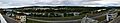
Panorama of Madawaska and the Saint John River as seen from Edmundston
See also
 In Spanish: Madawaska (Maine) para niños
