
Manasquan Reservoir facts for kids
Quick facts for kids Manasquan Reservoir |
|
|---|---|

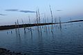
Manasquan Reservoir in Early Spring.
|
|

Manasquan Reservoir
Location in New Jersey

Manasquan Reservoir
Location in the United States
|
|
| Location | Monmouth County, New Jersey |
| Coordinates | 40°10′44″N 74°12′26″W / 40.178775°N 74.207239°W |
| Type | Reservoir |
| Primary inflows | Timber Swamp Brook |
| Primary outflows | Timber Swamp Brook |
| Basin countries | United States |
| Surface area | 770 acres (310 ha) |
| Max. depth | 40 ft (12 m) |
| Manasquan Reservoir County Park | |
|---|---|
| Type | Passive park |
| Location | Howell, New Jersey, United States |
| Nearest town | Howell, New Jersey |
| Area | 1,204 acres (4.87 km2) |
| Created | 1990 |
| Etymology | Lenape Native American dialect meaning "mouth of the river" |
| Owned by | Monmouth County |
| Operated by | Monmouth County Park System |
| Visitors | 1.1 million (in 2010) |
| Open | 7AM - dusk (Environmental Center: 10AM-5PM) |
| Status | Open all year |
| Camp sites | No |
| Hiking trails | 5 |
| Habitats | Bald eagle |
| Species | Birds: great blue heron, osprey, double-crested cormorant, bald eagle. Also: frogs, turtles, snakes, white-tailed deer, red fox, raccoon |
| Collections | Several, at Environmental Center |
| Designation | Wilderness Reserve |
| Parking | cars and trailers, 5 lots |
| Public transit access | None |
| Other information | Small picnic areas |
The Manasquan Reservoir is a super important place in Howell Township, Monmouth County, New Jersey. It's a big source of water for many towns and homes. It's also a huge 1,204-acre (4.87 km2) park!
This amazing spot is part of the Monmouth County Park System. It has lots of fun things to do, like trails for walking and biking, a visitor's center, and a nature center. You can also launch boats and go fishing. The reservoir itself was made by building a dam on the Manasquan River. It's managed by the New Jersey Water Supply Authority.
The park is super popular, with over a million visitors each year! People love the nature trails that go all around the reservoir. You can easily get there by car, and there are five parking lots, even one for vehicles with trailers. The trails are open for walkers, runners, hikers, bikers, and even people riding horses.
Contents
Explore the Trails at Manasquan Reservoir
The Manasquan Reservoir Park has five different trails for you to explore. The two longest are the Perimeter Trail, which is 5.1 miles long, and the Cove Trail, which is 1.1 miles long. There are also three shorter trails: the Wetlands Spur (0.2 mile), the Environmental Center's Bracken Trail (0.2 mile), and the Bear Swamp Connector Trail (0.5 mile).
In total, the park offers 6.2 miles of trails. Most of these trails are easy to moderate, so they are great for many different skill levels.
Discover the Perimeter Trail
The Perimeter Trail is 5.1 miles (8 km) long and goes all the way around the reservoir. This trail is great for walking, running, biking, and horseback riding. You'll see blue metal posts and brown wooden mile markers along the way.
The trail starts near the main visitor parking area. The mile markers go in a clockwise direction, starting from the southern part of the park. This trail is wide, usually between 8 and 24 feet (2.4 to 7.3 m) wide. The path is mostly made of crushed gravel, which makes it smooth and easy to walk on. Footbridges on the trail are 6 feet (1.8 m) wide.
The Perimeter Trail begins at the southern parking lot and heads west along Windeler Road. It then turns north near a wetlands area. As it continues north, it passes the environmental center around milepost 1.3. After that, it runs next to Georgia Tavern Road, which is the park's western edge.
Further along, the trail reaches Chestnut Point, where you can park and go fishing. It then turns east, passing Peskin Road and Southard Avenue. Around mile 3.3, it crosses a utility road and turns south, becoming narrower in some spots (about 8 feet wide). Finally, it widens again to about 20 feet as it reaches the visitor's parking lot at milepost 5.
Here are some cool things you might find along the Perimeter Trail:
| Milepost | What You'll Find |
|---|---|
| 0.0 | TRAIL START |
| 0.1 | Restrooms (Johnny-on-the-spot) |
| 0.5 | Two bridges |
| 0.6 | Entrance to the Cove Trail |
| 0.7 | Resting bench |
| 0.8 | Dike/bridge |
| 1.0 | MILE MARKER |
| 1.1 | Resting bench / Shortcut to Environmental Center |
| 1.2 | Cove Trail crossing |
| 1.3 | Environmental Center and parking / Park map |
| 1.7 | Chestnut Point parking / Restrooms / Large park map |
| 1.8 | Dike / Fishing pier |
| 2.0 | MILE MARKER |
| 2.4 | Wildlife viewing spot |
| 2.5 | Resting bench |
| 3.0 | MILE MARKER |
| 3.5 | Dam road crossing |
| 3.7 | Steel bridge |
| 3.8 | Restrooms |
| 4.0 | MILE MARKER |
| 4.5 | Service driveway / Park map / Bear Swamp Connector Trail (across Old Tavern Road) |
| 4.6 | Gate / Lakeside trail entrance |
| 5.0 | MILE MARKER |
| 5.1 | Visitor's western parking area (TRAIL END) |
Explore the Cove Trail
The Cove Trail is marked in green and is 1.1 miles long. It starts at milepost 0.6 of the Perimeter Trail and crosses it again at milepost 1.2. This trail ends at the Environmental Center.
It's a narrow trail, so you'll need to walk in single-file. It's also a bit more challenging than the flat Perimeter Trail. You might find some muddy spots because it's not maintained as much. This trail doesn't have a gravel base; it's just the natural ground.
The Cove Trail is a true nature trail, winding around a pond and wetlands in the southern part of the park. It has two bridges, two boardwalks over muddy areas, and a special spot for viewing wildlife.
Wetlands Spur and Lakeside Trail
Near the eastern parking lot (where people with boat trailers park), you'll find the Wetlands Spur. This trail is 0.2 miles long and leads to the lake, connecting to the eastern part of the Perimeter Trail.
Along this trail, you'll find a picnic area and a wildlife observation blind. As you continue east, you can access the lake's shore for sightseeing and fishing. There's also a small wooden bridge and a resting bench facing the lake. The trail ends when it connects to the Perimeter Trail.
Bracken Trail: A Short Nature Walk
The Bracken Trail is a small, hidden trail behind the Environmental Center. It's about 0.2 miles long and goes in a loop, ending back at the environmental center's parking lot.
This trail is narrow and only for walkers and hikers. It explores the area near the lake around the environmental center. The path is made of quarry stone. A cool feature of this trail is that it has about a dozen plants and animals labeled with their common and scientific names, so you can learn as you walk!
Bear Swamp Connector Trail
This trail is 0.5 miles long and is located in the eastern part of the park, in an area called Bear Swamp Tract. It connects Howell Township's Oak Glen Park to the Perimeter Trail.
It's about 8 feet wide and great for a casual walk. Remember, this trail leads away from the main park, so you'll need to use the same path to return to the Perimeter Trail. You can find it off mile 4.5 on the Perimeter Trail, but you'll need to cross Old Tavern Road to reach it.
The Environmental Center: Learn About Nature

The environmental center is a great place to visit and has its own parking lot. Inside, you'll find cool displays about the animals and fish that live in the area. There are also learning materials and windows where you can look out at the surrounding land and lake.
The center has restrooms, but remember that it closes earlier than the park itself. Behind the environmental center, there's a small, hidden loop trail that leads to the lake.
Fun Activities at the Reservoir
The Manasquan Reservoir offers lots of fun things to do outdoors!
- Boating: You can bring your own boats, kayaks, or canoes. If you don't have your own, you can rent kayaks or go on group boat rides. There are special piers to launch your boats into the lake.
- Fishing: Fishing is allowed in the lake, and there are many popular spots to cast your line.
- Trails: You can go horseback riding and biking on the park's trails.
- Playground: Near the visitor's center, there's a playground for younger children.
Visitor's Center: Your Park Hub
The visitor's center is a helpful place with restrooms and vending machines for snacks. You can also find park maps and information here. There's even a small shop where you can buy fishing supplies like bait.
The center has a cozy hall that looks like a winter lodge. Upstairs, there's an observation deck with binoculars you can use to get a closer look at the scenery. The visitor's center has three parking lots. The main lot is closest to the center. The western lot gives you easy access to the 5.1-mile perimeter trail, the children's playground, and a small picnic area by the lake. The eastern lot is for vehicles with boat trailers, as it's right next to the boat launching ramp.
Manasquan Reservoir: A Home for Wildlife
A special part of the reservoir is set aside as a wildlife reserve. This area helps protect the amazing aquatic animals that live here, like smallmouth bass, hybrid striped bass, tiger muskie, bullhead catfish, and panfish.
You can also spot many cool birds and land animals. Look for great blue herons, osprey, double-crested cormorants, and even bald eagles! Other animals you might see include frogs, turtles, snakes, white-tailed deer, red foxes, and raccoons.
The Reservoir: Our Drinking Water Source

The Manasquan Reservoir is super important because it provides a lot of the drinking water for Central New Jersey. It works with other reservoirs like the BMUA, Glendola, and Swimming River reservoirs.
The New Jersey Water Supply Authority operates the reservoir, which started working in 1990. It was created by building a dam on the Timber Swamp Brook. The reservoir can hold a massive four billion gallons of water and is up to 40 feet (12 m) deep. It can supply up to 30 million US gallons (110,000 m3) of water every day!
When the reservoir was built, some wetlands were affected. But New Jersey law says that for every wetland area that is changed, an equal amount must be recreated nearby.
Images for kids
-
Manasquan Reservoir in early spring

