
Map facts for kids

A map is a picture of an area, usually of the Earth or a part of it. Maps are different from regular photographs because they show more than just what something looks like. They also include special information and ideas from the mapmaker.
The word "map" can also mean a chart or drawing that shows how different things are connected. For example, it can show links between ideas, people, or events. This is why people who build websites call a list of web pages a "site map."
People who create maps are called cartographers. They are experts at drawing and designing maps.
Today, many maps are made using special computer systems called GIS. GIS stands for Geographic Information Systems. These systems store information based on where things are located, which helps cartographers make very detailed maps.
Since the Earth is round and most maps are flat (like on paper or a screen), maps need to be "projected." This means using mathematics to flatten the Earth's curved surface onto a flat one. There are many ways to do this, and each way changes how the map looks a little. The only map of the Earth that isn't projected is a globe, which is a round model of the Earth.
Contents
- Types of Maps: Exploring Our World
- Physical Maps: Showing Nature's Features
- Political Maps: Countries and Cities
- Relief Maps: Seeing the Ups and Downs
- Climatic Maps: Understanding Weather Patterns
- Geologic Maps: What's Under the Ground?
- Street Maps: Finding Your Way Around
- Topographical Maps: Detailed Land Views
- Thematic Maps: Focusing on One Topic
- Star Maps: Looking at the Sky
- Images for kids
- See also
Types of Maps: Exploring Our World
Maps come in many different types, each designed to show specific information. Here are some common kinds of maps you might see:
Physical Maps: Showing Nature's Features

A physical map shows the natural features of an area. These include things like mountains, rivers, lakes, and oceans. They often use different colors to show how high or low the land is. For example, green might show lowlands, and brown might show mountains.
Political Maps: Countries and Cities
A political map focuses on human-made features. These maps show country borders, states, city names, and capitals. They often use different colors to help you tell countries or states apart.
Relief Maps: Seeing the Ups and Downs
A relief map is a type of physical map that specifically shows the shape of the land. It highlights hills, valleys, and mountains. Sometimes, these maps are even 3D, so you can actually feel the bumps and dips of the land.
Climatic Maps: Understanding Weather Patterns
A climatic map shows the typical weather patterns of an area over a long time. These maps might show average temperatures, rainfall, or different climate zones around the world.
Geologic Maps: What's Under the Ground?
A geologic map shows the types of rocks and soil found on or under the Earth's surface. They can also show features like fault lines and volcanoes.
Street Maps: Finding Your Way Around
A street map shows roads, streets, and important buildings in a city or town. These are the maps you use to find directions when you're driving or walking.
Topographical Maps: Detailed Land Views
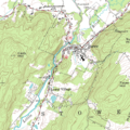
A topographical map is a very detailed map that shows both natural and human-made features. It uses special lines called contour lines to show the elevation (how high the land is) and the shape of the terrain.
Thematic Maps: Focusing on One Topic
A thematic map is designed to show a specific topic or theme. For example, a thematic map might show population density, how many people live in an area, or where different crops are grown.
Star Maps: Looking at the Sky
A star map (or celestial map) shows the positions of stars, constellations, and other objects in the night sky. These maps help astronomers and stargazers find their way around the universe.
Images for kids
-
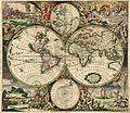
World map by Gerard van Schagen, Amsterdam, 1689
-
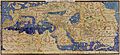
Muhammad al-Idrisi's Tabula Rogeriana (1154), one of the most advanced early world maps.
-
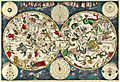
A celestial map from the 17th century, by the cartographer Frederik de Wit
-
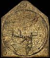
The Hereford Mappa Mundi from about 1300, Hereford Cathedral, England, is a classic "T-O" map with Jerusalem at the center, east toward the top, Europe the bottom left and Africa on the right.
-
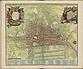
Map of Utrecht, Netherlands (1695).
-
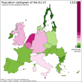
Cartogram: The EU distorted to show population distributions as of 2008.
-
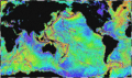
Map of large underwater features. (1995, NOAA)
-
Geological map of the Moon
-
A USGS digital raster graphic.
-
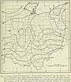
Mean Annual Temperature map of Ohio from "Geography of Ohio" 1923
-

In a topological map, like this one showing inventory locations, the distances between locations are not important. Only the layout and connectivity between them matters.


_(cropped).jpg)

See also
 In Spanish: Mapa para niños
