Marañón River facts for kids
Quick facts for kids Marañón River |
|
|---|---|

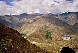
Valley of the Marañón between Chachapoyas (Leimebamba) and Celendín
|
|

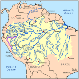
Map of the Amazon Basin with the Marañón River highlighted
|
|
| Other name(s) | Spanish: Río Marañón |
| Country | Peru |
| Physical characteristics | |
| Main source | Andes |
| River mouth | Amazon River |
| Length | 1,737 km (1,079 mi) |
| Basin features | |
| Basin size | 358,000 km2 (138,000 sq mi) |
| Tributaries |
|
The Marañón River (also called Río Marañón in Spanish) is a very important river in Peru. It is considered the main starting point, or "mainstem source," of the mighty Amazon River. The Marañón begins high up in the Andes mountains, about 160 km (100 mi) northeast of Lima, Peru's capital city.
The river flows through deep valleys in the Andes. It makes a big turn towards the northeast. Eventually, it cuts through the jungle and flows into the flat Amazon basin. While some people used to think the Marañón went all the way to the Atlantic Ocean, today it's generally agreed that it ends where it meets the Ucayali River. After that, the river is called the Amazon River.
Contents
The Marañón River: A Mighty Amazon Start
The Marañón River is Peru's second-longest river. This fact was shared in a report from 2005 by the National Institute of Statistics and Informatics.
The Amazon's Main Source
For a long time, the Marañón River was thought to be the true source of the Amazon. A map from 1707 by Padre Samuel Fritz showed it starting near Lake Lauricocha. Fritz believed the Marañón carried the most water into the Amazon. This made it the most important starting point.
Through the 1700s, 1800s, and even into the 1900s, the Marañón was widely seen as the Amazon's source. Later, explorers found two rivers that feed the Marañón in the high Andes: the Lauricocha and Nupe Rivers. These two rivers join together near the village of Rondos to form the Marañón.
Even though other rivers like the Apurimac and Mantaro also claim to be the Amazon's source, the Marañón River is still often called the "mainstem source." This is because it provides the largest amount of water to the Amazon each year.
Amazing Gorges and Jungles
The first part of the Marañón River has many "pongos." These are deep, narrow gorges found in jungle areas. They often have very strong and dangerous rapids.
The Pongo de Manseriche
The Pongo de Manseriche is the last big pongo on the Marañón. It is located just before the river reaches the flat Amazon basin. This gorge is about 5 km (3 mi) long. It is found between where the Rio Santiago joins the Marañón and the village of Borja.
In 1868, Captain Carbajal tried to go up the Pongo de Manseriche in a small steamboat. He described it as a huge crack in the Andes mountains. It was about 600 m (2,000 ft) deep. In some spots, it was only 30 m (100 ft) wide. The cliffs seemed to almost touch at the top. The Marañón river rushes through this canyon at speeds up to 20 km/h (12 mi/h). Many ships have been wrecked here, and many people have drowned.
The Low Jungle
After the Pongo de Manseriche, the river often has islands. From its low banks, you can usually only see a huge plain covered in forest. This area is known as the selva baja, or low jungle. It is also called Peruvian Amazonia. This region is home to many indigenous peoples. These include the Urarina people from the Chambira Basin, the Candoshi, and the Cocama-Cocamilla peoples.
The Grand Canyon of the Amazon
A 552-km (343-mi) part of the Marañón River is great for rafting. It is very similar to the Grand Canyon in the United States. Because of this, it has been called the "Grand Canyon of the Amazon." Most of this section is in a canyon that can be up to 3,000 m (9,800 ft) deep on both sides. This is more than twice as deep as the Colorado's Grand Canyon.
This area is dry and desert-like. Much of it gets only 250–350 mm (10–14 in) of rain each year. Some parts, like from Balsas to Jaén, are known as the hottest "infierno" (hell) area of Peru. The Marañón Grand Canyon section flows past the village of Calemar. This village was the setting for an important novel, La serpiente de oro (1935), by Peruvian writer Ciro Alegría.
Exploring the River
Many adventurers have explored the upper Marañón River. One of the first well-known trips down the Marañón happened in 1743. A Frenchman named Charles Marie de La Condamine traveled from the Chinchipe area all the way to the Atlantic Ocean. He did not start his boat trip at the very beginning of the Marañón because of the dangerous pongos. Even from where he started, he still faced several gorges, including the Pongo de Huaracayo and the Pongo de Manseriche.
Later, in 1936, Herbert Rittlinger tried to paddle the river. Sebastian Snow, another adventurer, explored most of the river by trekking from the source near Lake Niñacocha to the Chiriaco River.
In 1977, a group of four people, including Tom Fisher and Steve Gaskill, spent over a month exploring the river. They used kayaks and a raft to travel from Rondos to Nazareth. In 2004, Tim Biggs and his friends kayaked the entire river, from the Nupe River to Iquitos. More recently, in 2012, Rocky Contos traveled the entire river with different companions joining him along the way.
Dams and the River's Future
There are plans to build many hydroelectric dams on the Marañón River. About 20 large dams are planned in the Andes. Most of the electricity from these dams might be sent to other countries like Brazil, Chile, or Ecuador.
Surveys for these dams have been done. Environmental reports for some dams, like the Veracruz dam and the Chadin2 dam, have been available since 2009 and 2011. A law in 2011 mentioned that the energy was for "national demand." In 2013, Peru's President Ollanta Humala said the energy would help mines in different regions of Peru. Construction for one dam, the 406 MW dam in Chaglla District, started in 2012.
Concerns About Dams
Many people are worried about these dams. They are expected to change the main source of the Amazon River. The dams could stop the natural flow of silt (fine dirt) into the lower river. This could harm the homes and migration paths of fish and other water animals. Also, thousands of people living along the river might have to move from their homes. People are also concerned that the dams could damage a natural wonder that is "at least as nice as the Grand Canyon in the USA."
Local residents and conservation groups like SierraRios and International Rivers are working to stop the dams. Experts believe that building 151 new dams on the Amazon's main Andean rivers could cause big problems for the environment. This includes breaking the natural connection between the Andean mountains and the Amazon lowlands. It could also lead to more deforestation (cutting down forests) because of new roads and buildings needed for the dams.
See also
 In Spanish: Río Marañón para niños
- Extinct languages of the Marañón River basin
- List of rivers of Peru
- Loreto Region
- Maina Indians
- World Commission on Dams
 | James B. Knighten |
 | Azellia White |
 | Willa Brown |


