
Marias Pass facts for kids
Quick facts for kids Marias Pass |
|
|---|---|

Marias Pass obelisk and statue of John F. Stevens.
|
|
| Elevation | 5,213 ft (1,589 m) |
| Traversed by | |
| Location | Glacier County, Montana, U.S. |
| Range | Lewis Range |
| Coordinates | 48°19′06″N 113°21′19″W / 48.3183°N 113.3552°W |

Marias Pass
Location in the United States

Marias Pass
Location in Montana
|
|
Marias Pass is a mountain pass located in the Rocky Mountains in the western part of Montana, United States. It sits at an elevation of 5,213 feet (1,589 meters).
This important pass is on the southern edge of Glacier National Park. It is used by US Highway 2 and the BNSF Hi-Line Subdivision. Marias Pass is special because it is the lowest point where you can cross the Continental Divide between Canada and central New Mexico. It is also the northernmost pass in the U.S. that cars can use all year round.
Contents
Geography of Marias Pass
Marias Pass crosses the Continental Divide within the Lewis Range. This area marks the border between the Lewis and Clark National Forest and the Flathead National Forest.
The pass is also the southern end of the Continental Ranges. This is a large group of the Rocky Mountains that stretches north into British Columbia, Canada. South of the pass is the Great Bear Wilderness. To the north is Glacier National Park.
History of Marias Pass
Native Americans likely knew about Marias Pass for a very long time. It was a low and easy way to cross the Rocky Mountains. Early fur trappers might have also known about it. However, people did not realize its potential for larger travel until the mid-1800s.
Searching for a Railroad Route (1853)
In 1853, the U.S. Congress decided to fund surveys. The goal was to find the best routes for a transcontinental railroad across the country. This project was called the Pacific Railroad Surveys.
Isaac Stevens, who was the first governor of Washington Territory, led the survey for the northernmost route. He believed there had to be a good pass near the Marias River. He wrote that a chief from the Blackfeet tribe, named Little Dog, described the pass. The chief said it was a "broad, wide open valley" that Native Americans used to cross the mountains.
Governor Stevens continued his journey without finding the pass himself. He sent an engineer, Abiel Tinkham, to look for it. But Tinkham missed Marias Pass. He instead crossed at Cut Bank Pass, which is much higher.
Stevens then asked another survey member, James Doty, to try and find it from the east. Doty got close but did not fully explore the western side. Still, Stevens was sure that this was the "true Marias Pass" that the Little Dog chief had described.
News of this possible low pass was very important. In 1857, James G. Swan wrote that Governor Stevens had found a pass near the Marias River. Swan said it was much lower than another famous pass, Fremont's South Pass. Today, we know Marias Pass is indeed 2,337 feet lower than South Pass.
Discovering the Pass for the Railroad (1889)
Marias Pass was finally explored and mapped in December 1889. This was done by John Frank Stevens, a main engineer for the Great Northern Railway (GN). People had heard rumors about the pass for decades. But it took Stevens and a guide named Coonsah to officially find it. Coonsah was a Flathead guide who was with the Blackfoot people.
The pass was perfect for a railroad. It had a wide, open approach and a gentle slope. This meant less digging and rock work would be needed. Construction of the railroad through the pass began on August 1, 1890. The railroad followed the Middle Fork of the Flathead River west of the Continental Divide.
John Frank Stevens also found another important pass in central Washington. That pass is now named Stevens Pass after him.
Roosevelt Memorial Obelisk
A memorial for President Theodore Roosevelt stands at the top of Marias Pass. It is located along the Continental Divide. Building started in 1930. The original plan was to build a granite archway over the highway.
Later, it was decided to build an obelisk instead. An obelisk is a tall, four-sided stone pillar. This one is 60 feet (18 meters) tall. It goes 19 feet (5.8 meters) into the ground. It has a cement core covered with thick slabs of Montana granite. The obelisk was finished in 1931.
Today, U.S. Route 2 still uses the pass. The BNSF Railway also uses it. The railway line carries freight trains and Amtrak's Empire Builder passenger train. This line connects Chicago and the Pacific Northwest. A statue of John Frank Stevens stands at the summit of Marias Pass.
Images for kids
-
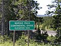
Marias Pass highway marker along US Route 2
-
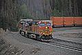
An eastbound BNSF intermodal train cresting the summit of the pass

.jpg)
See also
 In Spanish: Marias Pass para niños
