Maui Nui facts for kids
Maui Nui is a special name given by geologists to a huge, ancient Hawaiian island. It was formed from seven massive shield volcanoes. The word Nui means "great" or "large" in the Hawaiian language. So, Maui Nui means "Greater Maui."
This super-island was much bigger than any Hawaiian island we see today. Imagine an island 40% larger than the current Big Island of Hawaiʻi!
Contents
The Giant Island of Maui Nui
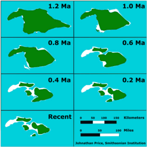
About 1.2 million years ago, Maui Nui was an enormous landmass. It covered an area of about 14,600 square kilometers (5,600 square miles). This was possible because sea levels were much lower back then.
During ice ages, a lot of Earth's water was frozen in huge glaciers. This meant less water was in the oceans, making sea levels drop. Because of these lower sea levels, more land was exposed, creating the giant Maui Nui.
How Maui Nui Became Separate Islands
Over millions of years, the huge volcanoes that made up Maui Nui slowly began to sink. This sinking happened because of their immense weight. Also, erosion from wind and water wore down the land.
As the land sank and eroded, the lower areas between the volcanoes started to flood. By about 200,000 years ago, Maui Nui had split into four separate islands. These are the islands we know today: Maui, Molokaʻi, Lānaʻi, and Kahoʻolawe.
Another part of the original Maui Nui, west of Molokaʻi, completely disappeared under the ocean. It is now covered by coral and is called Penguin Bank.
The Ocean Floor Around Maui Nui
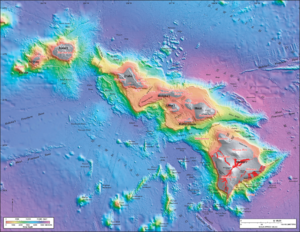
The ocean floor between the four main islands of Maui, Molokaʻi, Lānaʻi, and Kahoʻolawe is quite shallow. It's only about 500 meters (1,600 feet) deep. Because it's so shallow, all these islands, except Kahoʻolawe, were actually connected again during the last glacial maximum. This was about 20,000 years ago, when sea levels were at their lowest point.
However, at the outer edges of where Maui Nui once stood, the ocean floor drops very steeply. It plunges down to the deep abyssal ocean floor of the Pacific Ocean. These steep slopes can sometimes lead to massive landslides. One such landslide removed a large part of the northern side of East Molokaʻi.
Maui Nui in Modern Times
Today, the islands that remain from the ancient Maui Nui mostly make up Maui County. There's a small part of Molokaʻi that belongs to Kalawao County, but most of the area is part of Maui County.
Maui Nui was formed during a time period called the Pleistocene Epoch. This epoch lasted from about 2 million years ago until about 11,000 years ago. It was a time of many ice ages and big changes to Earth's geography.
 | Sharif Bey |
 | Hale Woodruff |
 | Richmond Barthé |
 | Purvis Young |


