Mere, Wiltshire facts for kids
Quick facts for kids Mere |
|
|---|---|
 |
|
| Population | 2,807 (in 2021) |
| OS grid reference | ST812322 |
| Civil parish |
|
| Unitary authority |
|
| Ceremonial county | |
| Region | |
| Country | England |
| Sovereign state | United Kingdom |
| Post town | WARMINSTER |
| Postcode district | BA12 |
| Dialling code | 01747 |
| Police | Wiltshire |
| Fire | Wiltshire |
| Ambulance | Great Western |
| EU Parliament | South West England |
| UK Parliament |
|
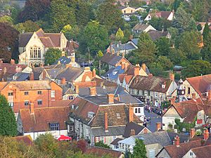
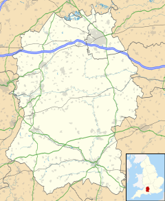
Mere is a small market town in Wiltshire, England. It's located at the very edge of Salisbury Plain, near the borders of Somerset and Dorset. The area around Mere includes smaller villages called hamlets, like Barrow Street, Burton, Charnage, Limpers Hill, Rook Street, and Southbrook.
A main road, the A303, used to go right through Mere. But in 1976, a bypass was built around the town to make traffic flow better. Mere has an old market square, even though markets haven't been held there for a while. You'll also see a town clock that chimes and a big church built in the 1400s. Castle Hill, a steep slope, rises up on the northwest side of Mere. Local businesses include a trout farm, candlemakers, a company that makes brushes, and large plant nurseries.
Contents
History of Mere
Ancient Times
People have lived in the Mere area for a very long time. We know this because of ancient burial mounds called bowl barrows. Four of these can be found on Long Hill, which overlooks the town.
On the edge of the parish is Whitesheet Hill. Here, you can find more burial mounds and an Iron Age hill fort called White Sheet camp. An old burial from the 600s or 700s has also been found in the town itself.
Medieval Period
Mere has had a church since the late 1100s. In the mid-1200s, the Earl of Cornwall built Mere Castle on a hill overlooking the town. The castle was later abandoned in the 1300s, and today only the earthworks (the remains of its foundations) can be seen. The Duchy of Cornwall still owns a lot of land in this area.
North of the town, Mere Down shows signs of medieval farming. You can see strip lynchets, which are long terraces created by plowing on hillsides.
How Mere is Governed
Mere is governed by a town council. This council is made up of local people who are elected to help run the town. They make decisions about local services and improvements.
The larger area is managed by Wiltshire Council. This is a bigger council that handles most of the important local government tasks for the whole county.
Mere is also part of an electoral ward, which is an area used for elections. This ward stretches from West Knoyle through Mere to Zeals and Kilmington. In 2011, about 4,285 people lived in this ward.
Places of Worship
St Michael's Church
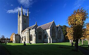
The Anglican church of St Michael the Archangel is a very old building. Parts of it were built in the 1200s, 1300s, and 1400s. It even has pieces from an even older church.
The church has a tall tower, about 124 feet (38 meters) high, with eight bells. It's special because it has 10 misericords. These are small wooden seats that choir members could lean on during long services. Some are from the 1400s, and others are from the early 1900s. The church was repaired and updated in 1856. In 1966, it was given a special status as a Grade I listed building, meaning it's very important historically.
Other Churches
Mere also had a Methodist Church, built in 1846. It was later sold in 2018 and is now a home.
The Mere United Reformed Church was built in 1868. Before this, there were other chapels in Mere dating back to the 1700s.
Another church, St Matthew's, was built in 1882 outside the town. It was a "mission church," meaning it was served by the clergy from St Michael's. This church closed in 2004 and was also sold for homes.
St Mary's Roman Catholic church was built in 1946. The community bought a special type of building called a Nissen hut to use as their church.
Important Buildings
Woodlands Manor is a beautiful old manor house located south of the town. It has a chapel and parts of it date back to the 1300s. It was later restored to look like it did in the 1600s. This building is also a Grade I listed building.
Other important buildings in Mere include the Old Ship Hotel, which was once a house built in 1711. The Chantry is a 1400s house that was used by priests. Dewes House is another historic building from the 1600s. These are all Grade II* listed buildings, meaning they are very important.
Schools in Mere
Mere has a primary school for younger children. For secondary school, students usually go to Gillingham School in Dorset, which is about 3.5 miles (5.6 km) away.
The current primary school opened in 1965 on land owned by the Duchy of Cornwall. It was first called Duchy Manor Secondary School. Later, in 1992, rooms for younger children were added. In 2004, the whole site became the primary school we know today.
Before this, there were other schools in Mere. The British School started around 1830. The National School opened in 1840 near St Michael's Church. These schools joined together in 1922.
Local Media
If you live in Mere, you can watch local news and TV shows from BBC West and ITV West Country. TV signals come from the Mendip TV transmitter.
For radio, you can listen to BBC Radio Wiltshire and BBC Radio Solent. Other local stations include Heart West, Vale FM, and Alfred Radio, which is a community station from Shaftesbury. The local newspapers that serve Mere are the Warminster Journal and the Wiltshire Times.
Things to Do in Mere
The town's library and museum are located in the old National School building, which was changed into these facilities in 1970.
Mere has three pubs (places where people can eat and drink): the George Inn, the Butt of Sherry, and the Walnut Tree Inn.
The Monarch's Way, a long walking path, goes right through the town. Mere is also part of the West Country Carnival circuit, which means it hosts fun carnival events.
The closest train station is in Gillingham, Dorset. From there, you can take a train on the West of England Main Line to places like Exeter and Waterloo.
Famous People from Mere
- Sir Harrison Birtwistle (1934–2022), a well-known composer.
- Edward Henslow (1879–1947), a British Army officer and a first-class cricketer.
- Lot Long (1823–1893), a thatcher whose photograph is on the cover of the famous Led Zeppelin album, Led Zeppelin IV.
- Sir Rowland Sperling (1874–1965), a diplomat and ambassador.
See also
In Spanish: Mere (Wiltshire) para niños
 | William M. Jackson |
 | Juan E. Gilbert |
 | Neil deGrasse Tyson |


