Merrick County, Nebraska facts for kids
Quick facts for kids
Merrick County
|
|
|---|---|
| County of Merrick | |

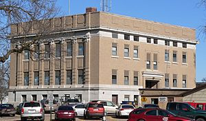
Merrick County Courthouse in Central City
|
|

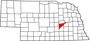
Location within the U.S. state of Nebraska
|
|
| Country | |
| State | |
| Established | November 4, 1858 |
| Organized | April 18, 1864 |
| Named for | Elvira Merrick |
| County seat | Central City |
| Largest city | Central City |
| Area | |
| • Total | 494 sq mi (1,280 km2) |
| • Land | 485 sq mi (1,260 km2) |
| • Water | 9.6 sq mi (25 km2) 1.9% |
| Highest elevation | 1,880 ft (570 m) |
| Lowest elevation | 1,345 ft (410 m) |
| Population | |
| • Estimate
(2021)
|
7,665 |
| • Density | 16.3/sq mi (6.3/km2) |
| Time zone | UTC−6 (Central) |
| • Summer (DST) | UTC−5 (CDT) |
| Area code | 308 |
| FIPS code | 31121 |
| GNIS feature ID | 835882 |
| Website | merrickcounty.ne.gov |
Merrick County is a county located in the state of Nebraska in the United States. In 2020, the county had a population of 7,668 people. The main town and county seat (the center of county government) is Central City.
Merrick County is part of the larger Grand Island area. This means it's connected to the economic and social life of Grand Island.
If you look at Nebraska license plates, you'll see that cars from Merrick County have the number 46. This number was given in 1922 because Merrick County had the 46th-largest number of registered vehicles in the state at that time.
Contents
History of Merrick County
Merrick County was officially created in 1858. It started to be organized as a county in 1864. The county was named after Elvira Merrick. She was the wife of Henry W. DePuy, a lawmaker who helped create the county.
When Merrick County was first formed, its borders were a bit different. Part of the Pawnee Reservation was included in the county. Later, in 1873, the state government changed the borders. This removed the reservation land from Merrick County. Eventually, in 1897, the Pawnee Reservation area became Nance County.
Geography and Landscape
Merrick County has mostly flat land with gentle hills. The land slopes down towards the east and northeast. A lot of the land in the county is used for farming.
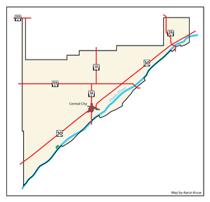
The Platte River flows along the southeastern edge of the county. Another smaller waterway, Prairie Creek, runs through the middle of the county. It flows in the same direction as the Platte River. Prairie Creek eventually joins the Platte River northeast of Merrick County. The county covers about 494 square miles. Most of this is land, with a small part being water.
Main Roads in Merrick County
These are the most important highways that run through Merrick County:
Neighboring Counties
Merrick County shares its borders with these other counties:
- Platte County – to the northeast
- Polk County – to the east
- Hamilton County – to the south
- Hall County – to the southwest
- Howard County – to the west
- Nance County – to the north
People of Merrick County
| Historical population | |||
|---|---|---|---|
| Census | Pop. | %± | |
| 1860 | 109 | — | |
| 1870 | 557 | 411.0% | |
| 1880 | 5,341 | 858.9% | |
| 1890 | 8,758 | 64.0% | |
| 1900 | 9,255 | 5.7% | |
| 1910 | 10,379 | 12.1% | |
| 1920 | 10,763 | 3.7% | |
| 1930 | 10,619 | −1.3% | |
| 1940 | 9,354 | −11.9% | |
| 1950 | 8,812 | −5.8% | |
| 1960 | 8,363 | −5.1% | |
| 1970 | 8,751 | 4.6% | |
| 1980 | 8,945 | 2.2% | |
| 1990 | 8,049 | −10.0% | |
| 2000 | 8,204 | 1.9% | |
| 2010 | 7,845 | −4.4% | |
| 2020 | 7,668 | −2.3% | |
| 2021 (est.) | 7,665 | −2.3% | |
| US Decennial Census 1790-1960 1900-1990 1990-2000 2010-2013 |
|||
In 2000, there were 8,204 people living in Merrick County. These people made up 3,209 households and 2,307 families. The population density was about 17 people per square mile.
Most people in the county were White (98.32%). A small number were Black or African American (0.22%), Native American (0.10%), or Asian (0.21%). About 2.05% of the population identified as Hispanic or Latino.
About 33.30% of households had children under 18 living with them. Many households (61.10%) were married couples. The average household had 2.51 people, and the average family had 2.99 people.
The median age in the county was 39 years old. About 27.50% of the population was under 18. About 17.50% of people were 65 years or older.
Towns and Villages
Merrick County has several communities where people live.
Cities
- Central City (This is the main town and county seat.)
Villages
Other Communities
- Archer (This is a "census-designated place," which means it's a community that the census bureau tracks, but it's not an officially incorporated city or village.)
Small Unincorporated Communities
These are smaller places that are not officially organized as cities or villages:
Townships
Counties in Nebraska are divided into smaller areas called townships. Here are the townships in Merrick County:
- Central
- Chapman
- Clarksville
- Lone Tree
- Loup
- Mead
- Midland
- Prairie Creek
- Prairie Island
- Silver Creek
- Vieregg
See also
 In Spanish: Condado de Merrick para niños


