Mid Atlantic water resource region facts for kids
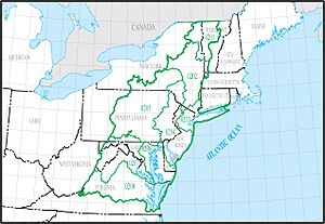
The Mid Atlantic water region is a big area in the United States where all the water flows to the same place. Think of it like a giant bowl where all the rain and rivers eventually end up in the same ocean or large body of water. The United States Geological Survey (USGS) uses these regions to study and manage water across the country.
This Mid Atlantic region is one of 21 main water areas in the U.S. It's known by a special code, 02. This region is huge, covering about 106,334 square miles (275,400 square kilometers)! It's divided into 8 smaller parts, called subregions, each with its own code from 0201 to 0208.
The water in this region eventually flows into the Atlantic Ocean. This includes water from parts of New York and Virginia. It also includes water that goes into Long Island Sound and even some that flows north into the Richelieu River, which then joins the Saint Lawrence River in Canada.
The Mid Atlantic water region covers all of Delaware and New Jersey, and also District of Columbia. It also includes parts of many other states like Connecticut, Maryland, Massachusetts, New York, Pennsylvania, Vermont, Virginia, and West Virginia.
Exploring Mid Atlantic Water Subregions
The Mid Atlantic water region is split into 8 smaller areas. Each of these subregions has its own unique features and rivers. Here's a look at them:
| Subregion Code | Subregion Name | What Water It Includes | Where It Is | Size | Map |
|---|---|---|---|---|---|
| 0201 | Richelieu Subregion | The Richelieu River area, including water from Lake Champlain, all within the U.S. | Located in New York and Vermont. | 7,720 sq mi (20,000 km2) | |
| 0202 | Upper Hudson Subregion | The Hudson River area, up to a certain point near Bear Mountain Bridge. | Located in New Jersey, New York, Massachusetts, and Vermont. | 12,666 sq mi (32,800 km2) | |
| 0203 | Lower Hudson–Long Island Subregion | Coastal waters from the Byram River to the Manasquan River, including the lower Hudson River, Long Island Sound, and Long Island itself. | Located in Connecticut, New Jersey, and New York. | 7,259 sq mi (18,800 km2) | |
| 0204 | Delaware–Mid Atlantic Coastal Subregion | Coastal waters from the Manasquan River to the Delaware River area, including Delaware Bay. | Located in Delaware, Maryland, New Jersey, New York, and Pennsylvania. | 17,977 sq mi (46,560 km2) | |
| 0205 | Susquehanna Subregion | The entire area drained by the Susquehanna River. | Located in Maryland, New York, and Pennsylvania. | 27,500 sq mi (71,000 km2) | |
| 0206 | Upper Chesapeake Subregion | The northern part of Chesapeake Bay and its rivers, not including the Susquehanna and Potomac Rivers. Also coastal areas from Delaware Bay to Chincoteague Inlet. | Located in Delaware, Maryland, Virginia, and Pennsylvania. | 5,871 sq mi (15,210 km2) | |
| 0207 | Potomac Subregion | The entire area drained by the Potomac River. | Located in District of Columbia, Maryland, Pennsylvania, Virginia, and West Virginia. | 14,679 sq mi (38,020 km2) | |
| 0208 | Lower Chesapeake Subregion | The southern part of Chesapeake Bay and its rivers. Also coastal areas from Chincoteague Inlet to the Back Bay area. | Located in Virginia. | 20,682 sq mi (53,570 km2) |
 | James Van Der Zee |
 | Alma Thomas |
 | Ellis Wilson |
 | Margaret Taylor-Burroughs |


