Monticello, Georgia facts for kids
Quick facts for kids
Monticello, Georgia
|
|
|---|---|

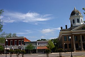
Town square
|
|
| Motto(s):
"Small town feel. Urban access. Endless opportunities."
|
|

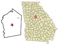
Location in Jasper County and the state of Georgia
|
|
| Country | United States |
| State | Georgia |
| County | Jasper |
| Area | |
| • Total | 4.28 sq mi (11.08 km2) |
| • Land | 4.16 sq mi (10.78 km2) |
| • Water | 0.12 sq mi (0.30 km2) |
| Elevation | 679 ft (207 m) |
| Population
(2020)
|
|
| • Total | 2,541 |
| • Density | 610.67/sq mi (235.78/km2) |
| Time zone | UTC-5 (Eastern (EST)) |
| • Summer (DST) | UTC-4 (EDT) |
| ZIP code |
31064
|
| Area code(s) | 706 |
| FIPS code | 13-52416 |
| GNIS feature ID | 0328830 |
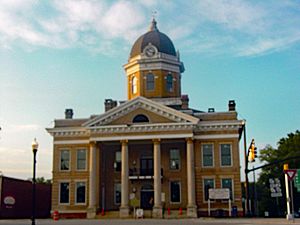
Monticello is the biggest city in Jasper County, Georgia, USA. It's also the main town where the county government is located. You can find old and important buildings here, like the Jasper County Courthouse and the Monticello Historic District. In 2020, about 2,541 people lived there. It's about 56 miles (90 km) southeast of Atlanta.
Contents
A Look at Monticello's History
Monticello was started in 1808. It became the main town for the new Jasper County. The city got its name from Monticello, which was the home of Thomas Jefferson. It officially became a town in 1810 and a city in 1901.
Monticello's Location and Landscape
Monticello is right in the middle of Jasper County. Its exact spot is 33°18′12″N 83°41′9″W / 33.30333°N 83.68583°W. Several main roads meet up in the center of town. These include Georgia State Routes 11, 16, 83, and 212.
SR 11 goes north 18 miles (29 km) to Mansfield. It also goes south 25 miles (40 km) to Gray. SR 16 travels east 17 miles (27 km) to Eatonton. It goes west the same distance to Jackson. SR 83 leads northeast 9 miles (14 km) to Shady Dale. It goes southwest 26 miles (42 km) to Forsyth. Finally, SR 212 heads northwest 42 miles (68 km) towards Atlanta. It also goes southeast 32 miles (51 km) to Milledgeville.
The city covers about 4.28 square miles (11.08 km2) of land. Only a small part, about 0.12 square miles (0.30 km2), is water. Monticello is part of the Oconee River area. This means its water flows into the Oconee River.
Monticello's Climate
Monticello has a climate with warm temperatures. Rain is spread out evenly throughout the year. This type of weather is called a "Humid subtropical climate."
| Climate data for Monticello, Georgia, 1991–2020 normals, extremes 1891–present | |||||||||||||
|---|---|---|---|---|---|---|---|---|---|---|---|---|---|
| Month | Jan | Feb | Mar | Apr | May | Jun | Jul | Aug | Sep | Oct | Nov | Dec | Year |
| Record high °F (°C) | 81 (27) |
85 (29) |
91 (33) |
99 (37) |
102 (39) |
108 (42) |
109 (43) |
108 (42) |
107 (42) |
98 (37) |
92 (33) |
84 (29) |
109 (43) |
| Mean maximum °F (°C) | 71.5 (21.9) |
75.1 (23.9) |
82.1 (27.8) |
86.2 (30.1) |
90.7 (32.6) |
95.1 (35.1) |
96.8 (36.0) |
96.3 (35.7) |
93.0 (33.9) |
86.9 (30.5) |
79.8 (26.6) |
73.5 (23.1) |
98.1 (36.7) |
| Mean daily maximum °F (°C) | 57.3 (14.1) |
61.4 (16.3) |
69.4 (20.8) |
76.7 (24.8) |
83.7 (28.7) |
89.2 (31.8) |
92.3 (33.5) |
91.0 (32.8) |
86.3 (30.2) |
77.7 (25.4) |
68.0 (20.0) |
60.1 (15.6) |
76.1 (24.5) |
| Daily mean °F (°C) | 43.3 (6.3) |
46.7 (8.2) |
53.6 (12.0) |
61.1 (16.2) |
69.1 (20.6) |
76.6 (24.8) |
80.1 (26.7) |
78.9 (26.1) |
73.1 (22.8) |
63.0 (17.2) |
52.6 (11.4) |
45.9 (7.7) |
62.0 (16.7) |
| Mean daily minimum °F (°C) | 29.4 (−1.4) |
31.9 (−0.1) |
37.8 (3.2) |
45.4 (7.4) |
54.6 (12.6) |
63.9 (17.7) |
68.0 (20.0) |
66.9 (19.4) |
60.0 (15.6) |
48.3 (9.1) |
37.2 (2.9) |
31.8 (−0.1) |
47.9 (8.9) |
| Mean minimum °F (°C) | 15.5 (−9.2) |
20.2 (−6.6) |
24.0 (−4.4) |
32.6 (0.3) |
42.0 (5.6) |
55.4 (13.0) |
62.1 (16.7) |
59.0 (15.0) |
48.7 (9.3) |
33.6 (0.9) |
24.4 (−4.2) |
20.1 (−6.6) |
13.9 (−10.1) |
| Record low °F (°C) | −7 (−22) |
6 (−14) |
10 (−12) |
25 (−4) |
36 (2) |
46 (8) |
54 (12) |
47 (8) |
40 (4) |
24 (−4) |
6 (−14) |
2 (−17) |
−7 (−22) |
| Average precipitation inches (mm) | 4.44 (113) |
4.33 (110) |
4.82 (122) |
3.56 (90) |
2.60 (66) |
3.79 (96) |
4.56 (116) |
3.92 (100) |
3.87 (98) |
2.94 (75) |
3.50 (89) |
4.37 (111) |
46.70 (1,186) |
| Average snowfall inches (cm) | 0.4 (1.0) |
0.2 (0.51) |
0.0 (0.0) |
0.0 (0.0) |
0.0 (0.0) |
0.0 (0.0) |
0.0 (0.0) |
0.0 (0.0) |
0.0 (0.0) |
0.0 (0.0) |
0.0 (0.0) |
0.0 (0.0) |
0.6 (1.51) |
| Average precipitation days (≥ 0.01 in) | 7.8 | 7.2 | 7.0 | 6.1 | 5.9 | 8.2 | 8.2 | 7.6 | 6.0 | 5.0 | 5.8 | 6.8 | 81.6 |
| Average snowy days (≥ 0.1 in) | 0.2 | 0.1 | 0.0 | 0.0 | 0.0 | 0.0 | 0.0 | 0.0 | 0.0 | 0.0 | 0.0 | 0.0 | 0.3 |
| Source 1: NOAA | |||||||||||||
| Source 2: National Weather Service | |||||||||||||
Understanding the Ground: Geology and Soils
The land under Monticello is made of a type of rock that is in between light and dark in color. On top of this rock, you'll find dark red clay. The very top layer of soil is a reddish-brown loam.
Who Lives in Monticello?
| Historical population | |||
|---|---|---|---|
| Census | Pop. | %± | |
| 1880 | 511 | — | |
| 1890 | 849 | 66.1% | |
| 1900 | 1,106 | 30.3% | |
| 1910 | 1,508 | 36.3% | |
| 1920 | 1,823 | 20.9% | |
| 1930 | 1,593 | −12.6% | |
| 1940 | 1,746 | 9.6% | |
| 1950 | 1,918 | 9.9% | |
| 1960 | 1,931 | 0.7% | |
| 1970 | 2,132 | 10.4% | |
| 1980 | 2,382 | 11.7% | |
| 1990 | 2,289 | −3.9% | |
| 2000 | 2,428 | 6.1% | |
| 2010 | 2,657 | 9.4% | |
| 2020 | 2,541 | −4.4% | |
| U.S. Decennial Census 1850-1870 1870-1880 1890-1910 1920-1930 1940 1950 1960 1970 1980 1990 2000 2010 |
|||
| Race | Num. | Perc. |
|---|---|---|
| White (non-Hispanic) | 1,036 | 40.77% |
| Black or African American (non-Hispanic) | 1,266 | 49.82% |
| Native American | 7 | 0.28% |
| Asian | 1 | 0.04% |
| Other/mixed | 85 | 3.35% |
| Hispanic or Latino | 146 | 5.75% |
In 2020, the census counted 2,541 people living in Monticello. There were 1,110 households and 698 families.
Schools in Monticello
Monticello has schools that are part of the Jasper County School District. This district teaches students from pre-school all the way to twelfth grade.
Jasper County School District
The Jasper County School District has two elementary schools. One is for grades K-2, and the other is for grades 3-5. There is also a middle school and a high school. The district has 132 full-time teachers. Over 2,181 students attend these schools.
- Jasper County Primary School
- Washington Park Elementary School
- Jasper County Middle School
- Jasper County High School
- Piedmont Academy - This is a private school for K3-12. It's a member of the Georgia Independent School Association. It was started in 1970.
Historic School Building
- Monticello High School - This old school building is now called Thomas Persons Hall.
Famous People from Monticello
Many interesting people have come from Monticello. Here are a few:
- William A. Connelly - He was the sixth Sergeant Major of the Army.
- Elizabeth Otis Dannelly - She was a poet who lived from 1838 to 1896.
- Rob Evan - A singer and actor who performed in many Broadway musicals.
- Willis Flournoy - A baseball player from the Negro leagues.
- Luke Gallows - A professional wrestler.
- Susan Holmes - She was a politician and the first female mayor of Monticello.
- Buckshot Jones - A NASCAR race car driver.
- Ulysses Norris - A football player for the University of Georgia. He played seven years in the NFL for the Detroit Lions and Buffalo Bills.
- John Gill Shorter - He was the 17th governor of Alabama.
- Sherry Smith - A Major League Baseball player. He pitched in two World Series.
- Odell Thurman - A football player for the University of Georgia and in the NFL.
- Trisha Yearwood - A famous country music singer.
See also
 In Spanish: Monticello (Georgia) para niños
 | Isaac Myers |
 | D. Hamilton Jackson |
 | A. Philip Randolph |


