
Mooloolah Valley, Queensland facts for kids
Quick facts for kids Mooloolah ValleyQueensland |
|||||||||||||||
|---|---|---|---|---|---|---|---|---|---|---|---|---|---|---|---|

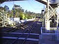
Mooloolah railway station
|
|||||||||||||||

Mooloolah Valley
Location in Queensland
|
|||||||||||||||
| Population | 3,629 (2021 census) | ||||||||||||||
| • Density | 198.3/km2 (514/sq mi) | ||||||||||||||
| Postcode(s) | 4553 | ||||||||||||||
| Area | 18.3 km2 (7.1 sq mi) | ||||||||||||||
| Time zone | AEST (UTC+10:00) | ||||||||||||||
| Location | |||||||||||||||
| LGA(s) | Sunshine Coast Region | ||||||||||||||
| State electorate(s) |
|
||||||||||||||
| Federal Division(s) | Fisher | ||||||||||||||
|
|||||||||||||||
Mooloolah Valley is a small community located in the Sunshine Coast Region of Queensland, Australia. It's a rural area, meaning it has lots of open spaces and natural beauty. In 2021, about 3,629 people lived here.
The original town within this area is called Mooloolah.
Contents
Exploring Mooloolah Valley's Location
Mooloolah Valley is found in the Sunshine Coast hinterland. This means it's a bit inland from the coast. It sits north of Landsborough.
The main railway line from Brisbane runs through Mooloolah Valley. You can catch trains heading south to Brisbane or north to Nambour and Gympie from the Mooloolah railway station.
Part of the eastern edge of Mooloolah Valley is formed by the Mooloolah River.
A Look at Mooloolah Valley's Past
The name Mooloolah comes from the Kabi language. It might mean "place of black snakes" or "place of snapper fish."
Early Days and Settlement
In 1861, a man named Edmund Lander was given permission to use the land for farming. This area was known as Mooloolah Plains. A year later, the lease was given to John Westaway.
Lander later bought 80 acres of land in 1869. This land was on the main road between Brisbane and Gympie, near the Mooloolah Bridge. The Mooloolah Post Office was set up on this property in 1872.
The town of Mooloolah was officially mapped out in 1884. The area was first called Mooloolah, but its name was changed to Mooloolah Valley on June 2, 1995.
Schools and Churches
Mooloolah Provisional School first opened its doors on February 6, 1894. It started with 28 students and Agnes May Black as the first teacher. On January 1, 1909, it became Mooloolah State School.
St Thomas' Anglican Church was officially opened on April 22, 1927.
The Glasshouse Country Uniting Church opened a new church in Beerwah on December 16, 2000. This church brought together several smaller churches from the area, including the Mooloolah Uniting Church.
Who Lives in Mooloolah Valley?
The population of Mooloolah Valley has been growing.
- In 2016, there were 3,321 people living here.
- By 2021, the population had grown to 3,629 people.
Places of Historical Importance
Mooloolah has a few sites that are listed for their historical importance:
- The Dularcha Railway Tunnel is about 1.5 kilometers south of the Mooloolah township.
- The Ewen Maddock House Site is located in Maddock Park, on Mooloolah Connection Road.
Learning in Mooloolah Valley
Mooloolah State School is a government primary school. It teaches students from Prep (the first year of school) to Year 6. The school is located on King Road. In 2017, it had 191 students.
There are no high schools directly in Mooloolah Valley. Students usually go to nearby towns for secondary school. Some options include:
- Maleny State High School in Maleny (to the west)
- Beerwah State High School in Beerwah (to the south)
- Chancellor State College in Sippy Downs (to the north-east)
- Nambour State College in Nambour (to the north)
- Palmview State Secondary College in Palmview (to the north-east) is a newer school that will offer all high school years by 2027.
Community Life and Services
The Mooloolah Valley Community Association is a group that helps the local community. They are based at the Mooloolah Community Centre. They raise money and offer services and events, such as:
- An Op Shop (second-hand store)
- 4 Seasons Markets
- A Community Assistance Program, which helps residents who are going through tough times.
- Different community events like Emergency Services Day and Christmas celebrations.
- A Men's Shed, which is a place for men to work on projects and connect.
The Mooloolah Public Hall opened in 1905. It's a place where community events like concerts, markets, and exercise classes are held.
The Sunshine Coast Regional Council also provides a mobile library service that visits Bray Road.
St Thomas' Anglican Church is located at 31 Bray Road. They hold weekly services on Wednesdays.
Images for kids
-
Mooloolah railway station
