Morgan County, Colorado facts for kids
Quick facts for kids
Morgan County
|
|
|---|---|

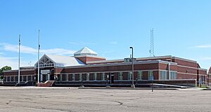
The Morgan County Justice Center in Fort Morgan
|
|

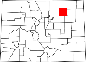
Location within the U.S. state of Colorado
|
|
 Colorado's location within the U.S. |
|
| Country | |
| State | |
| Founded | February 19, 1889 |
| Named for | Christopher A. Morgan |
| Seat | Fort Morgan |
| Largest city | Fort Morgan |
| Area | |
| • Total | 1,294 sq mi (3,350 km2) |
| • Land | 1,280 sq mi (3,300 km2) |
| • Water | 13 sq mi (30 km2) 1.0%% |
| Population
(2020)
|
|
| • Total | 29,111 |
| • Density | 23/sq mi (9/km2) |
| Time zone | UTC−7 (Mountain) |
| • Summer (DST) | UTC−6 (MDT) |
| Congressional district | 4th |
Morgan County is a county in the state of Colorado, USA. In 2020, about 29,111 people lived here. The main town, or county seat, is Fort Morgan. The county got its name from an old fort called Fort Morgan. This fort was named to honor Colonel Christopher A. Morgan.
Contents
Exploring Morgan County
Morgan County is a cool place to explore in Colorado. It has a mix of open spaces and friendly towns.
Where is Morgan County?
Morgan County is located in northeastern Colorado. It covers a total area of about 1,294 square miles. Most of this area, about 1,280 square miles, is land. The rest, about 13 square miles, is water.
Neighboring Counties
Morgan County shares its borders with several other counties:
- Logan County is to the northeast.
- Washington County is to the east and southeast.
- Adams County is to the southwest.
- Weld County is to the north and west.
Main Roads and Routes
Many important roads help people travel through Morgan County. These roads connect towns and make it easy to get around.
 Interstate 76
 I-76 Bus.
 U.S. Highway 6
 U.S. Highway 34
 State Highway 39
 State Highway 52
 State Highway 71
 State Highway 144
Parks and Trails
Morgan County is home to a state park and several trails. These are great for outdoor adventures.
- Jackson Lake State Park is a protected area.
- The American Discovery Trail passes through the county.
- You can also find parts of the Pawnee Pioneer Trails.
- The South Platte Trail is another path for explorers.
People of Morgan County
The number of people living in Morgan County has changed over the years. Here's how the population has grown:
| Historical population | |||
|---|---|---|---|
| Census | Pop. | %± | |
| 1890 | 1,601 | — | |
| 1900 | 3,268 | 104.1% | |
| 1910 | 9,577 | 193.1% | |
| 1920 | 16,124 | 68.4% | |
| 1930 | 18,284 | 13.4% | |
| 1940 | 17,214 | −5.9% | |
| 1950 | 18,074 | 5.0% | |
| 1960 | 21,192 | 17.3% | |
| 1970 | 20,105 | −5.1% | |
| 1980 | 22,513 | 12.0% | |
| 1990 | 21,939 | −2.5% | |
| 2000 | 27,171 | 23.8% | |
| 2010 | 28,159 | 3.6% | |
| 2020 | 29,111 | 3.4% | |
| 2023 (est.) | 29,524 | 4.8% | |
| U.S. Decennial Census 1790-1960 1900-1990 1990-2000 2010-2020 |
|||
In 2000, there were 27,171 people living in the county. The population density was about 21 people per square mile. About 30.4% of the people were under 18 years old. The average age was 34 years.
Towns and Villages
Morgan County has several cities, towns, and other communities. These are the places where people live and work.
Cities in Morgan County
Towns in Morgan County
Other Communities
Some areas are called census-designated places. These are communities that are not officially cities or towns, but they have a group of people living there.
- Blue Sky
- Jackson Lake
- Morgan Heights
- Orchard
- Saddle Ridge
- Snyder
- Trail Side
- Weldona
There are also other smaller communities that are not officially incorporated:
Images for kids
See also
 In Spanish: Condado de Morgan (Colorado) para niños
 | William M. Jackson |
 | Juan E. Gilbert |
 | Neil deGrasse Tyson |

