
Mount Chaval facts for kids
Quick facts for kids Mount Chaval |
|
|---|---|

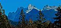
Mount Chaval seen from Sauk Mountain
|
|
| Highest point | |
| Elevation | 7,127 ft (2,172 m) |
| Prominence | 1,807 ft (551 m) |
| Geography | |

Mount Chaval
Location in Washington (state)

Mount Chaval
Location in the United States
|
|
| Parent range | North Cascades |
| Topo map | USGS Snowking Mountain |
| Type of rock | Chaval pluton |
| Climbing | |
| First ascent | September 20, 1946 by Richard Merritt, Keith and Ruth Rankin |
| Easiest route | Alpine Scrambling |
Mount Chaval is a tall, rocky mountain peak in Skagit County, Washington state. It stands at about 7,127 feet (2,172 meters) high.
This mountain is part of the Glacier Peak Wilderness, a special protected area where nature is kept wild. Mount Chaval is located west of the main ridge of the North Cascades mountain range. It's about 15 miles northeast of the town of Darrington.
Mount Chaval has two smaller peaks nearby, called East Peak and Middle Peak, both around 7,040 feet high. The closest taller mountain is Snowking Mountain, which is about 2.5 miles (4 kilometers) to the northeast. All the rain and melted snow from Mount Chaval flows into streams that eventually join the Skagit River.

What's the Weather Like on Mount Chaval?
Mount Chaval is in a place with a "marine west coast climate." This means it's near the ocean, so the weather is often mild and wet.
Most of the weather systems start over the Pacific Ocean. They travel northeast towards the Cascade Mountains. When these weather systems hit the tall peaks of the North Cascades, the air is forced to rise. This is called "orographic lift." As the air goes higher, it cools down and drops its moisture as rain or snow on the mountains.
Because of this, the western side of the North Cascades gets a lot of rain and snow, especially in winter. Winters are usually cloudy. But in summer, high-pressure systems over the Pacific Ocean often bring clear skies. The snow here tends to be wet and heavy, which can make avalanches more likely.

How Was Mount Chaval Formed?
The North Cascades mountains, where Mount Chaval is located, have very rugged land. You can see jagged peaks, sharp ridges, deep valleys carved by glaciers, and tall granite spires. All these different shapes in the land were created by geological events that happened millions of years ago. These events also caused big changes in how high the land is, which led to different climates.
The Cascade Mountains started forming millions of years ago, during a time called the late Eocene Epoch. This happened because the North American Plate (a huge piece of Earth's crust) was slowly moving over the Pacific Plate. This movement caused many volcanic eruptions.
Also, small pieces of Earth's crust, called terranes, crashed into North America. These collisions helped build the North Cascades about 50 million years ago. The rock that makes up Mount Chaval is a type of rock called Chaval pluton. It's made of rocks like diorite and tonalite.
About two million years ago, during the Pleistocene period, huge sheets of ice called glaciers moved across the land many times. As they moved, they scraped and shaped the landscape, leaving behind piles of rock. The "U"-shaped valleys you see in the mountains today were carved out by these glaciers. The combination of the land pushing upwards (called uplift) and cracks in the Earth's crust (called faulting), along with the glaciers, created the tall peaks and deep valleys of the North Cascades.
Images for kids
-
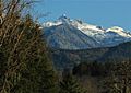
Looking southeast from Highway 20 through the Illabot Creek valley to Chaval
-
Chaval from Highway 530 north of Darrington


