
Mount Goode (California) facts for kids
Quick facts for kids Mount Goode |
|
|---|---|

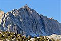
North aspect, from Long Lake
|
|
| Highest point | |
| Elevation | 13,085 ft (3,988 m) |
| Prominence | 845 ft (258 m) |
| Isolation | 1.64 mi (2.64 km) |
| Parent peak | Mount Gilbert (13,106 ft) |
| Naming | |
| Etymology | Richard Urquhart Goode |
| Geography | |

Mount Goode
Location in California

Mount Goode
Location in the United States
|
|
| Location | Fresno County / Inyo County California, U.S. |
| Parent range | Sierra Nevada |
| Topo map | USGS North Palisade |
| Type of rock | granite |
| Climbing | |
| First ascent | July 16, 1939 by Chester Versteeg |
| Easiest route | class 2 Southeast slope |
Mount Goode is a tall mountain in California, United States. It stands at 13,085 feet (3,988 meters) high. This mountain is part of the Sierra Nevada mountain range.
It sits right on the edge of Kings Canyon National Park and the John Muir Wilderness. It also marks the border between Fresno County and Inyo County. Mount Goode is about a mile west-northwest of Bishop Pass. It's also about 16 miles west of a town called Big Pine.
Mount Goode's History
The name "Mount Goode" was officially chosen in 1926. This decision was made by the United States Board on Geographic Names. They got the idea from the Sierra Club, a group that works to protect nature.
The mountain was named after Richard Urquhart Goode (1858–1903). He was a geographer for the United States Geological Survey. He was in charge of mapping the Pacific area.
The very first time someone climbed to the top of Mount Goode was on July 16, 1939. This amazing climb was done by Chester Versteeg. He was a well-known member of the Sierra Club.
Climbing Mount Goode
Many people enjoy climbing Mount Goode. There are several known routes that climbers use to reach the top. These routes are rated by how difficult they are.
Here are some of the established rock climbing routes on Mount Goode:
- Southeast Slope – This route was first climbed in 1939. It is rated as a class 3 climb, which is fairly easy for experienced climbers.
- West Ridge – This route is rated as class 5.4. This means it requires ropes and special climbing gear.
- No Goode – This route is also class 5.4 and involves three sections, called pitches.
- North Buttress – This is a harder route, rated class 5.9. It has nine pitches and was first climbed in 1974.
- Goode Earth – This route is rated class 5.10 and has six pitches. It is quite challenging.
- Sky Pilot – This is one of the most difficult routes, rated class 5.11. It has six pitches and was first climbed in 2014.
Weather and Climate
Mount Goode is in an alpine climate zone. This means it has cold, snowy winters and cool summers. The weather here is often affected by storms coming from the Pacific Ocean.
These storms travel east towards the Sierra Nevada mountains. As they get closer, the mountains force the air upward. This process is called orographic lift. When the air rises, it cools down and drops its moisture. This moisture falls as rain or snowfall on the mountain range.
The water from this mountain flows in two main directions. Some of the water drains west into the Kings River. Other water flows east to the Owens River through Bishop Creek.
Gallery
-
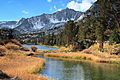
Mount Goode seen from the end of Long Lake.
-
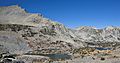
Mount Goode's easier southeast slope (on the left) as seen from Bishop Pass. Bishop Lake is in the center, and Saddlerock Lake is on the right.
-
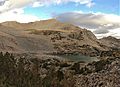
Mount Goode's southeast slope, viewed from Bishop Pass.
-
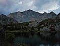
The north side of Mount Goode.


Images for kids
-
A close-up view of the North Face of Mount Goode.

