Mount Joy, Pennsylvania facts for kids
Quick facts for kids
Mount Joy, Pennsylvania
|
|
|---|---|

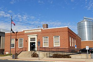
Mount Joy post office
|
|

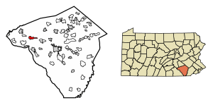
Location in Lancaster County, Pennsylvania
|
|
| Country | United States |
| State | Pennsylvania |
| County | Lancaster |
| Area | |
| • Total | 2.43 sq mi (6.28 km2) |
| • Land | 2.41 sq mi (6.24 km2) |
| • Water | 0.02 sq mi (0.04 km2) |
| Elevation | 371 ft (113 m) |
| Population
(2020)
|
|
| • Total | 8,325 |
| • Density | 3,452.92/sq mi (1,333.22/km2) |
| Time zone | UTC-5 (EST) |
| • Summer (DST) | UTC-4 (EDT) |
| ZIP code |
17552
|
| Area codes | 717 and 223 |
Mount Joy is a small town, called a borough, located in Lancaster County, Pennsylvania, United States. In 2020, about 8,346 people lived there. The town is known for its interesting history and unique name. It's a great place to learn about Pennsylvania's past.
Contents
Why is it Called Mount Joy?
The name "Mount Joy" might make you think of a mountain, but it's actually named after a famous ship! This ship was called the Mountjoy. It played a very important role during a historical event known as the Siege of Derry.
Irish Connections
Many of the first settlers in this part of Pennsylvania were Scots-Irish Protestants. They came from the northern part of Ireland. Because of this, many towns in the area have names that remind people of Ireland.
- Some nearby towns include Derry Township and Londonderry Township.
- You can also find Mount Joy Township and East Donegal Township.
- Other towns with Irish names are West Donegal Township and Rapho Township.
Fun Town Names
Mount Joy is often listed among towns in Pennsylvania Dutch Country that have funny or delightful names. These names often make people smile!
- Other towns with unique names include Intercourse and Blue Ball.
- You might also hear of Lititz, Bareville, and Bird-in-Hand.
- And don't forget Paradise!
Where is Mount Joy Located?
Mount Joy is in the northwestern part of Lancaster County. You can find its exact spot at 40°6′36″N 76°30′40″W / 40.11000°N 76.51111°W.
Getting Around Mount Joy
A main road, Pennsylvania Route 230, goes right through the middle of Mount Joy. It's called Main Street in town.
- If you head southeast on Route 230, you'll reach Lancaster in about 12 miles. Lancaster is the main city of the county.
- If you go northwest on Route 230, you'll get to Elizabethtown in about 6 miles.
- The state capital, Harrisburg, is about 25 miles northwest, also along Route 230.
Another road, PA-772, crosses Route 230 just west of town.
- PA-772 goes northeast about 7 miles to Manheim.
- It goes southwest about 5 miles to Marietta, which is on the Susquehanna River.
Water Around Town
Mount Joy covers an area of about 2.43 square miles (6.3 square kilometers). Most of this area is land. Only a small part, about 0.02 square miles (0.04 square kilometers), is water.
- Little Chiques Creek flows through the eastern side of Mount Joy.
- This creek eventually flows into Chiques Creek, which then joins the large Susquehanna River.
How Many People Live Here?
| Historical population | |||
|---|---|---|---|
| Census | Pop. | %± | |
| 1860 | 1,729 | — | |
| 1870 | 1,896 | 9.7% | |
| 1880 | 2,058 | 8.5% | |
| 1890 | 1,848 | −10.2% | |
| 1900 | 2,018 | 9.2% | |
| 1910 | 2,166 | 7.3% | |
| 1920 | 2,192 | 1.2% | |
| 1930 | 2,716 | 23.9% | |
| 1940 | 2,855 | 5.1% | |
| 1950 | 3,006 | 5.3% | |
| 1960 | 3,292 | 9.5% | |
| 1970 | 5,041 | 53.1% | |
| 1980 | 5,680 | 12.7% | |
| 1990 | 6,398 | 12.6% | |
| 2000 | 6,765 | 5.7% | |
| 2010 | 7,410 | 9.5% | |
| 2020 | 8,346 | 12.6% | |
| 2021 (est.) | 8,323 | 12.3% | |
| Sources: | |||
The population of Mount Joy has grown steadily over the years. In 2010, the town had 7,410 residents. By 2020, this number increased to 8,346 people.
Who Lives in Mount Joy?
Here's a look at the population from the 2010 United States Census:
- Total population: 7,410 people
- Males: 3,624
- Females: 3,786
- Most residents were White (6,809 people).
- There were also 549 people of Hispanic or Latino background.
- 187 people were African American.
- 58 people were Asian.
- 20 people were American Indian and Alaska Native.
- 170 people identified with two or more races.
Places to Visit and History
Mount Joy has several interesting places that tell stories about its past.
- Central Hotel: A historic hotel in the heart of town.
- Donegal Mills Plantation: A historic site with old buildings and a rich history.
- George Brown's Sons Cotton and Woolen Mill: An old mill that shows how textiles were made.
- Nissly Swiss Chocolate Company: A place connected to the history of chocolate making.
Famous People from Mount Joy
Many notable people have connections to Mount Joy.
- Kaufman Thuma "K.T." Keller: He was the president and CEO of the Chrysler Corporation, a big car company.
- Joseph F. Knipe: A brigadier general who served during the American Civil War.
- Donald Kraybill: A researcher and author known for his work on Anabaptist groups.
- Clarence Charles Newcomer: He was a United States federal judge.
- Winfred Trexler Root: A well-known historian.
- Mike Sarbaugh: A coach for the New York Mets baseball team.
- Bruce Sutter: A famous Major League Baseball pitcher and a member of the National Baseball Hall of Fame and Museum.
See also
 In Spanish: Mount Joy (Pensilvania) para niños
 | Ernest Everett Just |
 | Mary Jackson |
 | Emmett Chappelle |
 | Marie Maynard Daly |


