
Mount Song facts for kids
Quick facts for kids Mount Song |
|||||||||||||||||||||||
|---|---|---|---|---|---|---|---|---|---|---|---|---|---|---|---|---|---|---|---|---|---|---|---|

The Songshan Buddhist Academy, a modern monastery perched for effect on Lian Tian Feng.
|
|||||||||||||||||||||||
| Highest point | |||||||||||||||||||||||
| Peak | Lian Tian Feng | ||||||||||||||||||||||
| Elevation | 1,512 m (4,961 ft) | ||||||||||||||||||||||
| Prominence | 1,221 m (4,006 ft) | ||||||||||||||||||||||
| Isolation | 82.3 km (51.1 mi) SW | ||||||||||||||||||||||
| Parent peak | Mount Everest | ||||||||||||||||||||||
| Dimensions | |||||||||||||||||||||||
| Length | 100 km (62 mi) E-W | ||||||||||||||||||||||
| Width | 60 km (37 mi) N-S | ||||||||||||||||||||||
| Area | 450 km2 (170 sq mi) | ||||||||||||||||||||||
| Naming | |||||||||||||||||||||||
| English translation | "Lofty Mountain". | ||||||||||||||||||||||
| Language of name | |||||||||||||||||||||||
| Chinese name | |||||||||||||||||||||||
| Chinese | 嵩山 | ||||||||||||||||||||||
|
|||||||||||||||||||||||
| Geography | |||||||||||||||||||||||

Location in North China Plain
|
|||||||||||||||||||||||
| Country | China | ||||||||||||||||||||||
| Climbing | |||||||||||||||||||||||
| Easiest route | Cable car | ||||||||||||||||||||||
| UNESCO World Heritage Site | |||||||||||||||||||||||
| Official name | Historic Monuments of Dengfeng in "The Centre of Heaven and Earth" | ||||||||||||||||||||||
| Criteria | Cultural: iii, vi | ||||||||||||||||||||||
| Inscription | 2010 (34th Session) | ||||||||||||||||||||||
| Website | www.worldheritagesite.org/list/Dengfeng | ||||||||||||||||||||||
Mount Song (Chinese: 嵩山; pinyin: Sōngshān, meaning "lofty mountain") is a famous mountain range in central China. It is located in Henan Province, near the Yellow River. People have long seen Mount Song as the "center of Heaven and Earth." This idea comes from ancient Chinese stories about stars and the universe. Many Chinese rulers respected it as a very important place.
The mountain range is quite large. Its highest point is Lian Tian Feng, which is about 1,512 metres (4,961 ft) tall. Another important peak, also called Songshan, is about 1,492 metres (4,895 ft) high. This peak gives its name to the Songshan National Scenic Spot. The area around Mount Song is known for its beautiful forests and steep mountains. The famous Shaolin Monastery is also nearby.
People often talk about two main parts of Mount Song: Shaoshi Mountain (to the west) and Taishi Mountain (to the east). Some old stories say Mount Song has 72 peaks. This number is special in Chan Buddhist beliefs, representing a balance of forces. It is not based on actually counting all the peaks.
Contents
Exploring Mount Song's Geography
Where is Mount Song Located?
Mount Song is found in Henan Province, between the cities of Luoyang and Zhengzhou. It is part of a larger mountain system called the Qinling Range. The mountain range stretches for about 104 kilometres (65 mi) from east to west. Its width changes, but it is about 60 kilometres (37 mi) wide on average. The total area of the Songshan Mountains is around 450 square kilometres (170 sq mi).
The Qin-Huai Line: A Climate Divide
China has two very large rivers: the Yellow River (Huang He) and the Yangtze River. These rivers flow from west to east. The Yellow River is in the north, and the Yangtze River is to the south. They are separated by a natural boundary called the Qin-Huai Line.

This line is more than just a geographical feature; it also marks a big change in climate. North of this line, the weather is usually cooler and drier. This area is known as "North China." South of the line, the climate is warmer and wetter, called "South China." Mount Song is in the northern part, so it has the "North China" climate.
The Yellow River starts high up in Tibet and carries a lot of fine yellow dust called loess. This dust gives the river its yellow color. Over time, this dust can build up and cause floods, but dams now help control the river.

Mount Song's Weather
Mount Song experiences different weather throughout the year. Summers are warm, and winters are cold. The mountain gets most of its rain in July and August. Snowfall is common in the winter months.
| Climate data for Mount Song, elevation 1,178 m (3,865 ft), (2003–2020 normals) | |||||||||||||
|---|---|---|---|---|---|---|---|---|---|---|---|---|---|
| Month | Jan | Feb | Mar | Apr | May | Jun | Jul | Aug | Sep | Oct | Nov | Dec | Year |
| Mean daily maximum °C (°F) | 1.1 (34.0) |
4.1 (39.4) |
10.5 (50.9) |
16.8 (62.2) |
21.3 (70.3) |
25.1 (77.2) |
25.4 (77.7) |
24.0 (75.2) |
20.1 (68.2) |
15.6 (60.1) |
9.2 (48.6) |
3.1 (37.6) |
14.7 (58.5) |
| Daily mean °C (°F) | −2.8 (27.0) |
−0.2 (31.6) |
5.5 (41.9) |
11.6 (52.9) |
16.6 (61.9) |
20.5 (68.9) |
21.5 (70.7) |
20.2 (68.4) |
16.3 (61.3) |
11.6 (52.9) |
5.4 (41.7) |
−0.7 (30.7) |
10.5 (50.8) |
| Mean daily minimum °C (°F) | −5.7 (21.7) |
−3.2 (26.2) |
2.0 (35.6) |
7.7 (45.9) |
12.9 (55.2) |
17.0 (62.6) |
18.6 (65.5) |
17.6 (63.7) |
13.5 (56.3) |
8.7 (47.7) |
2.4 (36.3) |
−3.7 (25.3) |
7.3 (45.2) |
| Average precipitation mm (inches) | 18.3 (0.72) |
21.6 (0.85) |
22.8 (0.90) |
46.7 (1.84) |
77.2 (3.04) |
87.5 (3.44) |
157.1 (6.19) |
141.0 (5.55) |
117.1 (4.61) |
54.0 (2.13) |
37.7 (1.48) |
11.2 (0.44) |
792.2 (31.19) |
| Average precipitation days (≥ 0.1 mm) | 5.3 | 6.2 | 6.5 | 7.4 | 8.0 | 9.1 | 13.2 | 13.3 | 11.4 | 8.1 | 6.8 | 4.3 | 99.6 |
| Average snowy days | 5.8 | 5.8 | 4.4 | 0.7 | 0 | 0 | 0 | 0 | 0 | 0.1 | 3.1 | 4.6 | 24.5 |
| Average relative humidity (%) | 51 | 59 | 55 | 59 | 62 | 69 | 84 | 86 | 78 | 66 | 60 | 48 | 65 |
| Mean monthly sunshine hours | 152.2 | 143.8 | 182.9 | 205.4 | 206.1 | 185.7 | 132.8 | 124.5 | 132.9 | 157.9 | 157.4 | 170.6 | 1,952.2 |
| Percent possible sunshine | 48 | 46 | 49 | 52 | 48 | 43 | 30 | 30 | 36 | 46 | 51 | 56 | 45 |
| Source: China Meteorological Administration | |||||||||||||
Mount Song's Natural and Cultural Treasures
How the Mountains Were Formed
Mount Song is a very old place, geologically speaking. It was formed by three major mountain-building events over billions of years. These events are named after local spots: the Songyang, Zhongyue, and Shaolin orogenies. Because of this long history, the Songshan Geopark is often called "a textbook of geological history."
Climbing and Exploring the Peaks
The highest points of Mount Song form a U-shape. This shape separates the rivers flowing northeast (to the Yellow River) from those flowing southeast (to the Huai River). Inside this U-shape is the Shaoyang Valley, which is now part of the city of Dengfeng. This valley is surrounded by tall, sacred mountains.
Many ancient religious buildings, both Taoist and Buddhist, are found in this area. Today, these sites are important for tourism. People come to see the geology, enjoy outdoor activities, and learn about the history.
| Peak | Elev (m) | Prom (m) | Latitude | Longitude | Shaoshi/ Taishi |
|---|---|---|---|---|---|
| Zhāo Yuè Fēng | 976 | 52 | 34.46227 N | 112.958576 E | Shaoshi |
| Yíng Xiá Fēng | 1138 | 255 | 34.469532 N | 112.958631 E | Shaoshi |
| Ruì Yīng Fēng | 1018 | 48 | 34.465569 N | 112.937857 E | Shaoshi |
| Qīng Liáng Fēng | 1159 | 53 | 34.463239 N | 112.929083 E | Shaoshi |
| Lián Tiān Fēng | 1512 | 1221 | 34.472416 N | 112.934647 E | Shaoshi |
| Qióng Bì Fēng | 1487 | 47 | 34.470582 N | 112.931695 E | Shaoshi |
| Zǐ Wēi Fēng | 1472 | 13 | 34.470817 N | 112.933883 E | Shaoshi |
| Tiān Dé Fēng | 1033 | 25 | 34.472878 N | 112.958058 E | Shaoshi |
| Bái Dào Fēng | 1485 | 35 | 34.473727 N | 112.938172 E | Shaoshi |
Protecting Mount Song's Heritage
Early Efforts to Preserve Sites
In the past, China had different ideas about its historical sites. Sometimes, old buildings were destroyed, but other times, they were saved as symbols of national pride. For example, the Shaolin Temple was damaged in 1928, but later, new museums were built to protect important artifacts.
The idea of public parks and tourism started to grow in China. Before, only rich people had private gardens. But then, the idea that everyone should be able to enjoy beautiful places became popular. The China Travel Service was created in 1927 to help Chinese people travel and see their own country's sights. This agency helped decide which places were important to visit.
Changes Under Chairman Mao
When the People's Republic of China began in 1949, led by Chairman Mao Zedong, there were big changes. At first, tourism was not seen as important. Many historical sites were used for other purposes or even destroyed. While there were attempts to protect some buildings, other goals often came first.
Later, after Mao Zedong passed away in 1976, China started to change its approach. Leaders like Deng Xiaoping helped the country focus on economic growth and protecting its heritage. New laws were made to protect cultural sites.
Mount Song as a Protected Area
After 1991, China opened its borders more, and people became very interested in preserving China's natural and cultural heritage. They started creating "protected areas" (PAs), like national parks. By 2018, China had over 11,800 protected areas. Tourism grew a lot, with millions of people visiting these sites.
Mount Song became a national scenic area. This means it is a park that protects beautiful views and allows tourism. In 1986, a plan was made to restore places like the Shaolin Monastery, which had been damaged. Other important sites in the area include Songyang Academy, Zhongyue Temple, and the Star Observatory.
Mount Song UNESCO Global Geopark
The Shaolin Monastery is part of the Songshan Global Geopark. In 2010, eight important locations at the foot of Mount Song in Dengfeng were recognized as a World Heritage Site by UNESCO. These sites include many ancient buildings and temples.
Important Sites at Mount Song
Mount Song is home to many historical and religious places. These sites are often called "geosites" because they are important parts of the geopark, even if they are cultural rather than purely geological.
World Heritage Sites of Mount Song
The Songshan World Heritage Site includes 367 buildings in eight main groups. These groups are located around the Shaoyang Valley, often within the city of Dengfeng itself.
| Name | Location | Description | WP Articles | |
|---|---|---|---|---|
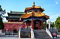
| 1. Taishi Que Gates and Zhongyue Temple | ||||
 |
Zhongyue Temple | 34°27′28″N 113°04′04″E / 34.457811°N 113.0676911°E | This is an important Taoist temple complex. It was built in the 5th century, replacing an older temple. The current design dates back to the Jin dynasty (1115–1224). | Dengfeng |
 |
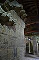
Taishi Que Gates | 34°27′07″N 113°04′04″E / 34.451896°N 113.067802°E | These are ancient stone gateposts built in 118 AD. They used to stand in front of the old Taishi Temple. Today, they are protected inside a special building. | Dengfeng, Que (tower) |
| 2. Shaoshi Que Gates | ||||
 |
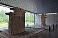
Shaoshi Que Gates | 34°29′34.94″N 112°58′37.21″E / 34.4930389°N 112.9770028°E | These stone gateposts once stood before the Shaoshishan Temple, which is no longer there. They are now protected. | Dengfeng, Que (tower) |
| 3. Quimu Que Gates | ||||
 |
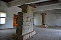
Qimu Que Gates | 34°28′26.92″N 113°2′28.48″E / 34.4741444°N 113.0412444°E | These are also ancient stone gateposts that used to be in front of the Qimu Temple. They show pictures, including some that look like visitors from the Roman Empire. | Dengfeng, Que (tower) |
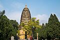
| 4. Songyue Temple Pagoda | ||||
 |
Songyue Temple Pagoda | 34°30′5.83″N 113°0′57.34″E / 34.5016194°N 113.0159278°E | This is a beautiful, twelve-sided pagoda built between 508 and 511 AD. It was once part of a temple and palace that are no longer standing. | Dengfeng, Songyue Pagoda |
| 5. Architectural Complex of Shaolin Temple, Kernel Compound, Chuzu Temple, Pagoda Forest | ||||
Mount Song is very important for Chinese Buddhism. It is home to the Shaolin Temple, which is believed to be where Zen Buddhism began. The temple also has a large collection of pagodas, which are tall, multi-storied towers.
Besides the Shaolin Temple, you can find other Buddhist and Taoist monasteries. The Zhongyue Temple is one of China's oldest Taoist temples. The Songyang Academy nearby was one of the four most important schools in ancient China. The Tang dynasty (618–907) pagodas at the Fawang Temple are also on the mountain.
Images for kids
-
Zhongyue Temple
-
Taishi Que Gates
-
Shaoshi Que Gates
-
Qimu Que Gates
-
Songyue Temple Pagoda
See also
- International Network of Geoparks
- List of Geoparks
- List of UNESCO Global Geoparks in Asia
