
Skagway, Alaska facts for kids
Quick facts for kids
Municipality of Skagway
|
||
|---|---|---|
|
Borough
|
||

Aerial view of Skagway in 2009
|
||
|
||
| Nickname(s):
"Gateway to the Klondike"
|
||

Location of Skagway in Alaska
|
||
| Country | ||
| State | Alaska | |
| Founded | 1897 | |
| Incorporated (city) | June 28, 1900 | |
| Incorporated (borough) | June 5, 2007 | |
| Area | ||
| • Borough | 9.49 sq mi (24.59 km2) | |
| • Land | 9.45 sq mi (24.46 km2) | |
| • Water | 0.05 sq mi (0.12 km2) | |
| Elevation | 33 ft (10 m) | |
| Population
(2020)
|
||
| • Borough | 1,240 | |
| • Density | 130.7/sq mi (50.43/km2) | |
| • Urban
(CDP)
|
1,164 | |
| Time zone | UTC−9 (AKST) | |
| • Summer (DST) | UTC−8 (AKDT) | |
| Zip Code |
99840
|
|
| Area code(s) | 907 | |
| FIPS code | 02-70760 | |
| GNIS feature ID | 1414754 2339479 |
|
| Website | skagway.org | |

Skagway is a special kind of town in Alaska, located in the part of the state that looks like a panhandle. In 2020, about 1,240 people lived here. This number often doubles in the summer because so many tourists visit!
Skagway is found on the Taiya Inlet and was a very important port during the Klondike Gold Rush. The White Pass and Yukon Route is a historic narrow-gauge railway that starts here. It used to be for mining, but now it's a popular ride for tourists in the summer. Many cruise ships stop in Skagway, making tourism a huge part of the town's economy.
Skagway is also featured in famous books like Jack London's The Call of the Wild and Jason's Gold by Will Hobbs. The movie North to Alaska (1960) starring John Wayne was filmed nearby.
The name Skagway comes from a Tlingit word, sha-ka-ԍéi. This word describes the rough seas in the Taiya Inlet caused by strong north winds.
Contents
History of Skagway
The Meaning Behind the Name
The name Skagway comes from the Tlingit word shԍagéi. This word means "rough seas in the Taiya Inlet" that are caused by strong north winds. But, it literally means "beautiful woman."
This is because Shԍagéi or Skagway is the nickname of Kanagu. She is a mythical woman who, according to legend, turned into stone at Skagway bay. She is said to cause the strong winds that blow towards Haines, Alaska. So, the rough seas from these winds are named after her nickname.
It's believed that the stone formation of Kanagu might be Face Mountain, which you can see from Skagway bay. The Tlingit name for Face Mountain means Kanagu’s Image.
From Ancient Times to the Gold Rush
The area where Skagway is today has been home to Tlingit people for a very long time. They fished and hunted, and became successful by trading with other groups.
One important person in early Skagway was William "Billy" Moore. He was a former steamboat captain who explored the White Pass in 1887. He believed there was gold in the Klondike region. In 1887, he and his son claimed land at the mouth of the Skagway River. They thought this was the best way to get to the goldfields. They built a cabin, a sawmill, and a dock, getting ready for future gold miners.
At that time, the border between Canada and the United States in this area wasn't clear. But everything changed with the Klondike Gold Rush. Gold was found in the Klondike region of Canada in 1896.
On July 29, 1897, the ship Queen arrived at Moore's dock with the first group of gold seekers. More ships brought thousands of hopeful miners. Moore's land was quickly taken over by people looking for gold.

The Gold Rush Boom
The population of the area grew very fast, reaching about 30,000 people. Many were American miners. Some realized how hard the journey to the goldfields would be and decided to stay in Skagway. They provided goods and services to the miners.
Within weeks, Skagway had many stores, saloons, and offices. By spring 1898, the town had about 8,000 residents, and about 1,000 miners passed through each week. By June 1898, Skagway was the biggest city in Alaska, with 8,000 to 10,000 people.
With so many people, some residents started offering transportation to miners, often at very high prices. A group of miners tried to form a town council to protect their interests. But as these members left to mine for gold, a man named Jefferson Randolph "Soapy" Smith gained control of the town.


Miners often started their journey by climbing the mountains over the White Pass above Skagway. Then they crossed into Canada to Bennett Lake. There, they built boats and floated down the Yukon River to the goldfields near Dawson City. Others went to nearby Dyea and crossed the Chilkoot Pass. This was an old Tlingit trade route. Dyea became less popular because its harbor was too shallow for larger ships.
Canadian officials required each miner to bring one ton (909 kg) of supplies into Canada. This was to make sure they wouldn't starve in winter. This was a huge challenge for the miners and their pack animals climbing the steep pass.
In 1898, a 14-mile steam-powered tramway was built up the Skagway side of the White Pass. This made it easier for miners who could pay to use it. The White Pass and Yukon Route railway also began laying tracks in Skagway in May 1898. This railway made Dyea less important, as Skagway had both a deep-water port and the train.
McCabe College, the first school in Alaska to offer a high school education to prepare students for college, started being built in 1899 and was finished in 1900.
By 1899, fewer people were looking for gold, and Skagway's economy started to slow down. By 1900, when the railroad was finished, the gold rush was almost over. In 1900, Skagway became the first official city in the Alaska Territory. Much of Skagway's history was saved by early residents like Martin Itjen. He ran tours and helped preserve the gold rush cemetery. He also bought Soapy Smith's saloon and turned it into Skagway's first museum, saving many old artifacts.
In July 1923, President Warren G. Harding visited Skagway during his trip through Alaska. He was the first U.S. President to visit Alaska while in office.
Skagway's Location and Climate
Where is Skagway?
Skagway is located in a narrow valley that was carved by glaciers. It's at the very top of the Taiya Inlet, which is the northern end of the Lynn Canal. This is the most northern fjord on the Inside Passage along Alaska's south coast. It's about 90 miles northwest of Juneau, Alaska's capital city.
The U.S. Census Bureau says that Skagway has a total area of about 464 square miles. Most of this (452 square miles) is land, and a small part (12 square miles) is water. It is the smallest borough in Alaska.
Nearby Areas
- Haines Borough, Alaska – to the south and west
- Stikine Region, British Columbia – to the north and east
Protected Natural Areas
- Klondike Gold Rush National Historical Park (part of it is here)
- Tongass National Forest (part of it is here)
Skagway's Weather
Skagway has a cool-summer climate. It's in a "rain shadow" because of the coastal mountains. This means it gets less rain than other places nearby. For example, it gets only half as much rain as Juneau. Summers are dry, but winters are cold.
The highest temperature ever recorded in Skagway was 92°F (33°C). This happened in three different years, most recently in 1975. The lowest temperature ever recorded was -24°F (-31°C) on February 2, 1947.
| Climate data for Skagway, Alaska | |||||||||||||
|---|---|---|---|---|---|---|---|---|---|---|---|---|---|
| Month | Jan | Feb | Mar | Apr | May | Jun | Jul | Aug | Sep | Oct | Nov | Dec | Year |
| Record high °F (°C) | 52 (11) |
60 (16) |
59 (15) |
76 (24) |
82 (28) |
89 (32) |
92 (33) |
91 (33) |
77 (25) |
68 (20) |
59 (15) |
52 (11) |
92 (33) |
| Mean daily maximum °F (°C) | 26.9 (−2.8) |
33.2 (0.7) |
39.4 (4.1) |
50.1 (10.1) |
58.7 (14.8) |
65.1 (18.4) |
66.9 (19.4) |
64.9 (18.3) |
57.4 (14.1) |
48.0 (8.9) |
36.3 (2.4) |
32.0 (0.0) |
48.2 (9.0) |
| Daily mean °F (°C) | 22.0 (−5.6) |
27.8 (−2.3) |
33.2 (0.7) |
41.5 (5.3) |
49.4 (9.7) |
56.1 (13.4) |
58.7 (14.8) |
56.9 (13.8) |
50.9 (10.5) |
42.6 (5.9) |
31.5 (−0.3) |
27.2 (−2.7) |
41.5 (5.3) |
| Mean daily minimum °F (°C) | 17.3 (−8.2) |
22.3 (−5.4) |
27.0 (−2.8) |
32.8 (0.4) |
40.1 (4.5) |
47.1 (8.4) |
50.4 (10.2) |
48.9 (9.4) |
44.2 (6.8) |
37.2 (2.9) |
26.8 (−2.9) |
22.8 (−5.1) |
34.7 (1.5) |
| Record low °F (°C) | −15 (−26) |
−15 (−26) |
−5 (−21) |
14 (−10) |
14 (−10) |
23 (−5) |
23 (−5) |
23 (−5) |
19 (−7) |
8 (−13) |
−6 (−21) |
−14 (−26) |
−15 (−26) |
| Average precipitation inches (mm) | 2.17 (55) |
1.84 (47) |
1.55 (39) |
1.20 (30) |
1.30 (33) |
1.11 (28) |
1.19 (30) |
2.19 (56) |
4.04 (103) |
4.24 (108) |
2.89 (73) |
2.43 (62) |
26.15 (664) |
| Average snowfall inches (cm) | 14.2 (36) |
9.7 (25) |
3.3 (8.4) |
1.0 (2.5) |
0.1 (0.25) |
0 (0) |
0 (0) |
0 (0) |
0 (0) |
1.2 (3.0) |
8.6 (22) |
11.1 (28) |
49.2 (125.15) |
| Average precipitation days (≥ 0.01 inch) | 9 | 9 | 10 | 8 | 8 | 8 | 9 | 13 | 16 | 18 | 13 | 12 | 133 |
| Source: Western Regional Climate Centre | |||||||||||||
People of Skagway
| Historical population | |||
|---|---|---|---|
| Census | Pop. | %± | |
| 1900 | 3,117 | — | |
| 1910 | 872 | −72.0% | |
| 1920 | 494 | −43.3% | |
| 1930 | 492 | −0.4% | |
| 1940 | 634 | 28.9% | |
| 1950 | 758 | 19.6% | |
| 1960 | 659 | −13.1% | |
| 1970 | 675 | 2.4% | |
| 1980 | 768 | 13.8% | |
| 1990 | 692 | −9.9% | |
| 2000 | 862 | 24.6% | |
| 2010 | 968 | 12.3% | |
| 2020 | 1,240 | 28.1% | |
| 2023 (est.) | 1,095 | 13.1% | |
| U.S. Decennial Census | |||
Skagway first appeared in the U.S. Census in 1900. It was the second-largest city in Alaska then. Its population was 3,117. But the population quickly dropped to 872 by 1910 as the gold rush ended. It took 90 years for the population to almost reach that number again (862 in 2000).
In 2007, Skagway changed from being just a city to a larger "municipality and borough." This means it includes the town and the surrounding area.
In 2000, there were 862 people living in Skagway. About 92.3% were White, and 3.0% were Native American. The average age was 40 years old.
Economy and Tourism
Money in Skagway
The average income for a household in Skagway in 2000 was $49,375. For families, it was $62,188. Very few people (about 3.7%) lived below the poverty line.
Visiting Skagway


Many visitors come to the Klondike Gold Rush National Historical Park and the White Pass Trail and Chilkoot Trail. Skagway has a historic district with about 100 buildings from the gold rush time.
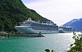
About a million tourists visit Skagway every year. Most of them (about three-quarters) arrive on cruise ships. The White Pass and Yukon Route train runs during the summer mainly for tourists. The The Days of '98 Show is a popular performance in Skagway that tells stories from the gold rush.
Getting Around Skagway


Skagway is one of only three towns in Southeast Alaska that you can reach by road. The Klondike Highway, finished in 1978, connects Skagway to the rest of the United States, Whitehorse, Yukon, and northern British Columbia.
Skagway is also an important stop for the Alaska Marine Highway, which is Alaska's ferry system. It's the northern end of the busy Lynn Canal ferry route.
The White Pass and Yukon Route railway used to connect Whitehorse, Yukon, to Skagway. Today, trains run several times a week from May to September. They go from Skagway to a small community called Carcross. From there, passengers (mostly tourists) can take a bus to Whitehorse.
Lua error: unknown error.
Skagway Airport has flights from two small airlines: Alaska Seaplanes and Air Excursions.
News and Media
Skagway has its own newspaper, The Skagway News, which comes out twice a month. There's also a local public radio station, KHNS, which has studios in Skagway and nearby Haines. Another radio station from Juneau, KINY, also broadcasts in Skagway.
You can also find copies of the free regional newspaper Capital City Weekly in Skagway.
Images for kids
-
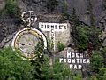
Gold Rush-era advertisements on a mountain
-
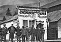
Jeff. Smith's Parlor in 1898, during the Klondike gold rush
-
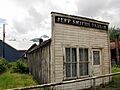
Jeff. Smith's Parlor in 2009, before restoration
-
Diamond Princess and Pacific Princess cruise ships
-
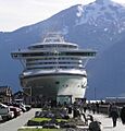
A cruise ship docked in Skagway
-
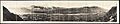
Panoramic photograph of Skagway, around 1915


See also
 In Spanish: Skagway para niños
