Lacey, Washington facts for kids
Quick facts for kids
Lacey
|
|
|---|---|

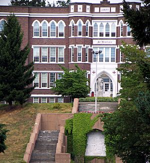
St. Martin's University in Lacey
|
|

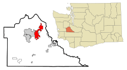
Location within Thurston County in Washington
|
|
| Country | United States |
| State | Washington |
| County | Thurston |
| Incorporated | December 5, 1966 |
| Government | |
| • Type | Council–manager |
| Area | |
| • City | 17.66 sq mi (45.75 km2) |
| • Land | 17.20 sq mi (44.55 km2) |
| • Water | 0.47 sq mi (1.20 km2) |
| Elevation | 203 ft (62 m) |
| Population
(2020)
|
|
| • City | 53,526 |
| • Estimate
(2023)
|
58,326 |
| • Rank | US: 669th WA: 23rd |
| • Density | 3,057.67/sq mi (1,180.57/km2) |
| • Metro | 298,758 (US: 172nd) |
| Time zone | UTC-8 (Pacific (PST)) |
| • Summer (DST) | UTC-7 (PDT) |
| ZIP code |
98516
|
| Area code | 360 |
| FIPS code | 53-36745 |
| GNIS feature ID | 1512362 |
Lacey is a city in Thurston County, Washington, in the United States. It's like a neighbor city to Olympia. In 2020, about 53,526 people lived there. This makes Lacey the 24th largest city in Washington state. You can find Lacey right next to Interstate 5, between Olympia and the Nisqually River. The Nisqually River is also the border with Pierce County.
Contents
History of Lacey
Lacey was first called Woodland. This name came from Isaac and Catherine Wood, who settled there in 1853. By 1891, a railroad came to Woodland. The people wanted a post office, but their request was turned down. Why? Because there was already another town named Woodland by the Columbia River.
So, they picked a new name: Lacey. This name probably came from O. C. Lacey, who was a judge in Olympia. In the 1950s, the small areas of Woodland and Chambers Prairie joined together to form Lacey.
People started thinking about making Lacey an official city in 1963. They wanted to become a city to avoid being taken over by Olympia. The first vote to become a city happened in 1964, but it didn't pass.
They tried again in 1966. This time, the area they wanted to include was larger. On November 8, 1966, people voted again, and this time it passed! Lacey officially became a city on December 5, 1966.
After Lacey became a city, Olympia tried to take back some of the land. They used an old law to let everyone in Olympia vote on it, not just the people in the area. Olympia's plan was approved, and they took back about 2 square miles of land from Lacey.
In the past, Lacey's main jobs were in cattle, milk, wood products, and shops. Many people who lived in Lacey worked in Olympia, Fort Lewis, or Tacoma. But now, Lacey has grown a lot. It has its own businesses and communities, becoming a city in its own right.
Geography of Lacey
Lacey is located between Olympia to the west and the Nisqually River delta to the east. The Nisqually River delta is home to the Billy Frank Jr. Nisqually National Wildlife Refuge, a special place for nature.
The northern part of Lacey reaches the Nisqually Reach on Puget Sound. This area is next to Tolmie State Park. To the south, Lacey's border is a part of the BNSF Railway, which is a big train line for goods and passengers.
The city covers about 16.51 square miles (42.76 square kilometers). Most of this area, about 16.06 square miles (41.60 square kilometers), is land. The rest, about 0.45 square miles (1.17 square kilometers), is water.
People in Lacey (Demographics)
| Historical population | |||
|---|---|---|---|
| Census | Pop. | %± | |
| 1960 | 6,630 | — | |
| 1970 | 9,696 | 46.2% | |
| 1980 | 13,940 | 43.8% | |
| 1990 | 19,279 | 38.3% | |
| 2000 | 31,226 | 62.0% | |
| 2010 | 42,393 | 35.8% | |
| 2020 | 53,526 | 26.3% | |
| 2023 (est.) | 58,326 | 37.6% | |
| U.S. Decennial Census 2020 Census |
|||
In 2020, the census showed that 53,526 people lived in Lacey. There were 20,984 households in the city.
In 2010, there were 42,393 people living in Lacey. The city had 16,949 households. About 33.9% of these households had children under 18 living with them. The average household had 2.44 people.
The average age of people in Lacey was 34 years old. About 24.6% of the residents were under 18 years old.
Neighborhoods
Mushroom Corner is a well-known area in Lacey. It's located along Interstate 5. The "corner" is where Steilacoom Road SE and Marvin Road SE meet. This community got its name because there used to be a mushroom farm nearby called Ostrom Mushroom Farm.
Economy
The biggest shopping area in Lacey is the South Sound Center. It first opened in 1966. It used to be an indoor mall, but it changed in 2000.
Lacey also has a large industrial area called Hawks Prairie. This area has many big warehouses. These warehouses store and send out goods for the Puget Sound region. They also connect to the Port of Seattle and Port of Tacoma. For example, Target opened a huge distribution center in Lacey in 2003. It's one of the largest warehouses in the U.S.
Sustainability Efforts
Lacey is known for being a "Green Power Community." This means it uses a lot of renewable energy sources. The city uses 100 percent green electrical energy for all its buildings, parks, and streetlights.
Lacey also provides electric vehicle charging stations. The city is working to change its vehicles to use electricity, hybrid power, or biofuel. For 26 years, Lacey has been named a "Tree City, USA" by the National Arbor Day Foundation. This shows its commitment to planting and caring for trees.
Education
Lacey is part of the North Thurston Public Schools district. This is the largest school district in Thurston County.
There are also several private schools in Lacey:
- Holy Family School (Preschool to 8th grade)
- Faith Lutheran School (Preschool to 8th Grade)
- Foundation Campus, which includes Community Christian Academy (Pre-school to Middle School) and Northwest Christian High School
- Pope John Paul II High School
Lacey is also home to Saint Martin's University. This is a private four-year university that started in 1895. It was founded by the Order of Saint Benedict.
South Puget Sound Community College also has a campus in Lacey. It opened a larger branch campus in 2015.
Public Secondary Schools
- Aspire Middle School (Magnet)
- Chinook Middle School
- Komachin Middle School
- Nisqually Middle School
- Salish Middle School
- North Thurston High School
- River Ridge High School
- Timberline High School
Infrastructure
Transportation
Interstate 5 goes right through Lacey from west to east. This freeway connects big cities like Seattle and Portland, Oregon. In 2020, Lacey opened Washington's first special road design called a "diverging diamond interchange" on Interstate 5.
Lacey has about 178.6 miles (287.4 kilometers) of streets. The city is served by Intercity Transit, which is the public bus system for Thurston County. You can also catch Amtrak trains at the Centennial Station near Lacey's southern border. Trains like the Cascades and Coast Starlight stop there daily.
Healthcare
The biggest hospital in Thurston County is Providence St. Peter Hospital. It has 390 beds and is located northwest of Lacey. This hospital moved to its current location in 1971.
Lacey also has an emergency room that is part of the MultiCare Capital Medical Center. This facility opened in 2023 and has 18 beds.
Notable People
Many interesting people have connections to Lacey, including:
- Elizabeth Ayer, an architect
- Andrew Barkis, a state legislator
- Brad Blackburn, an MMA fighter
- Tom Dutra, a soccer player and coach
- Karen Fraser, a state legislator
- Ron Holmes, an American football player
- Kasey Keller, a soccer player
- Mike Kreidler, a former U.S. representative and state legislator
- Janice Langbehn, a gay activist
- Ed Murray, a state legislator and former mayor of Seattle
- Mike Sellers, an American football player
- Jerramy Stevens, an American football player
- Jonathan Stewart, an American football player
- Joseph Wohleb, an architect
- Kim Wyman, a former Secretary of State of Washington
Sister City
Lacey has a special connection with a city in Poland called Mińsk Mazowiecki. They are "sister cities," which means they share cultural and educational ties.
See also
 In Spanish: Lacey (Washington) para niños

