Nanticoke, Pennsylvania facts for kids
Quick facts for kids
Nanticoke, Pennsylvania
|
||
|---|---|---|
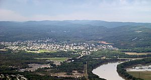
Aerial view of Nanticoke
|
||
|
||
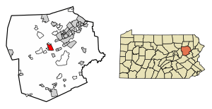
Location of Nanticoke in Luzerne County, Pennsylvania
|
||
| Country | United States | |
| State | Pennsylvania | |
| County | Luzerne | |
| Settled | 1800 | |
| Incorporated (borough) | 1874 | |
| Incorporated (city) | 1926 | |
| Government | ||
| • Type | City Council | |
| Area | ||
| • Total | 3.55 sq mi (9.20 km2) | |
| • Land | 3.46 sq mi (8.95 km2) | |
| • Water | 0.09 sq mi (0.25 km2) | |
| Elevation | 696 ft (212 m) | |
| Population
(2020)
|
||
| • Total | 10,628 | |
| • Density | 3,074.34/sq mi (1,186.90/km2) | |
| Time zone | UTC-5 (Eastern (EST)) | |
| • Summer (DST) | UTC-4 (EDT) | |
| Zip Code |
18634
|
|
| Area code(s) | 570 | |
| FIPS code | 42-52584 | |
| Website | nanticokecity.com | |
Nanticoke is a city in Luzerne County, Pennsylvania, United States. It's located in the beautiful Wyoming Valley region. As of 2020, about 10,628 people call Nanticoke home. This makes it the third-largest city in Luzerne County.
Nanticoke covers about 3.6 square miles of land. It's known for its history as a coal mining town. Today, it's home to the main campus of Luzerne County Community College, which covers 167 acres. The city is divided into areas like Honey Pot, Downtown, and Hanover Section.
| Top - 0-9 A B C D E F G H I J K L M N O P Q R S T U V W X Y Z |
History of Nanticoke
Nanticoke has a rich past, from its Native American roots to its growth as a coal mining hub.
How Nanticoke Got Its Name
The name Nanticoke comes from the Nanticoke Native American tribe. Their name, Nentego, means "tidewater people." They moved to the Wyoming Valley when their original homes near Chesapeake Bay were changed by European settlers. The tribe had a village in the valley for a long time.
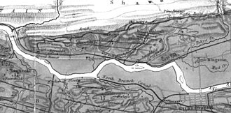
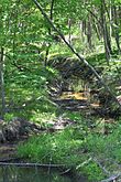
The nearby Nanticoke Creek is also named after this tribe. It was once called Muddy Run, but the name Nanticoke Creek appeared on maps as early as 1776.
Early Settlements and Mills
In 1778, Mason F. Alden and John Alden built a forge (a place to shape metal) on Nanticoke Creek. That same year, a log gristmill (a mill for grinding grain) was built by Mr. Chapman. By 1793, both a sawmill and a gristmill were operating on the creek.
Becoming a Borough and a City

In the 1800s, Nanticoke was formed from parts of Hanover Township and Newport Township. It became a village in 1830. Then, on January 31, 1874, it officially became a borough. A borough is a type of town with its own local government.
Nanticoke grew a lot between 1917 and 1925. This growth allowed it to become a "third class city" in Pennsylvania. Citizens voted for a city government in 1924, and the first mayor and council members took office in January 1926. Dan Sakowski was Nanticoke City's first mayor.
The Coal Mining Era
Nanticoke became very important in the late 1800s and early 1900s because of anthracite coal mining. Many European immigrants came to Nanticoke to work in the mines. At its busiest, in the 1930s, over 27,000 people lived in the city!
However, when the coal mining industry slowed down, Nanticoke's population began to shrink. The end of mining also left behind old mines, coal processing buildings, and water pollution in Nanticoke Creek.
Concrete City: A Unique Historical Site
Near Nanticoke's Hanover Section, you can find Concrete City. This unique place was built in 1911 by a coal company. It was abandoned in 1924 but was made an historic site in 1998. Its old buildings still stand today and are a cool place to visit.
Nanticoke Today
In 1967, Luzerne County Community College (LCCC) was opened in Nanticoke. This two-year college has its main campus here, covering about 167 acres. LCCC also has other learning centers around Northeastern Pennsylvania.
In 2006, Nanticoke City faced financial challenges and was granted "economically distressed city" status by the state. This helped the city work towards a stronger future.
-
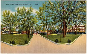
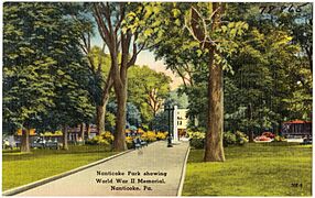
An old postcard of the World War II memorial in Nanticoke Park
Population and People
Nanticoke's population has changed a lot over the years. It grew quickly during the coal mining boom.
| Historical population | |||
|---|---|---|---|
| Census | Pop. | %± | |
| 1880 | 3,884 | — | |
| 1890 | 10,044 | 158.6% | |
| 1900 | 12,116 | 20.6% | |
| 1910 | 18,877 | 55.8% | |
| 1920 | 22,614 | 19.8% | |
| 1930 | 26,043 | 15.2% | |
| 1940 | 24,387 | −6.4% | |
| 1950 | 20,160 | −17.3% | |
| 1960 | 15,601 | −22.6% | |
| 1970 | 14,638 | −6.2% | |
| 1980 | 13,044 | −10.9% | |
| 1990 | 12,267 | −6.0% | |
| 2000 | 10,955 | −10.7% | |
| 2010 | 10,465 | −4.5% | |
| 2020 | 10,628 | 1.6% | |
At its peak in the 1930s, Nanticoke had over 27,000 residents. As of the 2020 census, the population was 10,628.
Many people in Nanticoke have roots from different parts of Europe. The most common backgrounds include:
Geography and Location
Nanticoke is located at 41°11′58″N 75°59′57″W / 41.19944°N 75.99917°W. It's part of the Wyoming Valley, close to the Susquehanna River. The city sits at an elevation of 696 feet (212 meters).
The Susquehanna River is an important waterway nearby. Bridges like the Lower Broadway Street Bridge and the South Cross Valley Expressway connect Nanticoke to Plymouth Township across the river.
Nanticoke has a hilly landscape. Two creeks, Nanticoke Creek and Newport Creek, flow through the city.
Neighboring Towns
Nanticoke shares its borders with:
- Hanover Township (to the east and south)
- Newport Township (to the west and south)
- Plymouth Township (to the north)
Getting Around Nanticoke
Nanticoke is connected by major roads and offers public transportation.
Main Roads
Important highways that serve Nanticoke include:
 I-81
I-81 US 11
US 11 PA 29
PA 29
Public Buses
The Luzerne County Transportation Authority provides bus service in Nanticoke. You can use these buses to travel within the city and to other nearby communities.
Train Service
Rail line service is available through the Norfolk Southern Railway. Nanticoke is on their Sunbury Line, and there's a small freight yard here.
Airports Nearby
For air travel, several airports are within reach:
- The Wilkes-Barre/Scranton International Airport is in Pittston Township. It offers flights from major airlines.
- The Wilkes-Barre Wyoming Valley Airport is just three miles north of Wilkes-Barre.
- The Hazleton Municipal Airport is two miles northwest of Hazleton.
Education and Culture
Nanticoke is a place where learning and community are important.
Schools and Colleges
- The Greater Nanticoke Area School District serves students in Nanticoke and nearby townships. The district covers about 52 square miles.
- Luzerne County Community College (LCCC) is a two-year college right in Nanticoke. It offers many different programs and has an open admissions policy for most courses. Besides its main campus, LCCC has 11 other learning centers in the region.
- The Mill Memorial Library is also available for reading and research.
Local Media
Several radio stations are licensed in Nanticoke, including WQFM 92.1 FM, WSFX-FM at 89.1, WVHO 94.5 FM, and WAZL 730 AM.
Famous People from Nanticoke
Many talented individuals have come from Nanticoke!
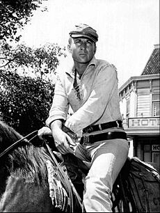
- Nick Adams (1931–1968) was an actor and screenwriter. He was well-known for his role as Johnny Yuma in the TV series The Rebel.
- Steve Bilko (1928–1978) played professional baseball for the St. Louis Cardinals.
- Al Cihocki (1924–2014) was a Major League Baseball infielder for the Cleveland Indians.
- Stanley Dudrick (1935–2020) was a surgeon who developed total parenteral nutrition, a way to feed patients through an IV.
- John S. Fine (1893–1978) served as the 35th Governor of Pennsylvania from 1951 to 1955.
- Pete Gray (1915–2002) played major league baseball even after losing his right arm in a childhood accident. His amazing story was told in the 1986 TV movie A Winner Never Quits.
- Paul Kanjorski (born 1937) is a former U.S. Representative.
- Jerry Orbach (1935–2004) was an actor, famous for being a cast member of Law & Order.
- Frank Piekarski (1879–1951) was an American football player and coach who later became a judge.
- David A. Randall (1905–1975) was an American book dealer and scholar.
- Doug Turley (1918–1992) was an American football end for the Washington Redskins.
See also
 In Spanish: Nanticoke (Pensilvania) para niños
 | William Lucy |
 | Charles Hayes |
 | Cleveland Robinson |


