
National Register of Historic Places listings in De Baca County, New Mexico facts for kids

De Baca County in New Mexico is home to some really special places! These places are so important that they are listed on the National Register of Historic Places. This list helps protect buildings, sites, and objects that are important to American history.
There are 5 historic spots in De Baca County that have made it onto this important list. All of these places are also recognized by the state of New Mexico on its own list of cultural properties. Let's explore some of these amazing historic treasures!
Contents
Discovering De Baca County's Historic Treasures
What is the National Register of Historic Places?
The National Register of Historic Places is the official list of the United States' historic places. It includes districts, sites, buildings, structures, and objects. These places are considered important to American history, architecture, archaeology, engineering, and culture. Being on the Register means these places are recognized for their value and often helps protect them.
Exploring De Baca County
De Baca County, New Mexico is a county located in the east-central part of New Mexico. It's known for its wide-open spaces and its connection to the history of the American West. The county seat, or main town, is Fort Sumner. All the historic places on the National Register in De Baca County are found in or near Fort Sumner.
Amazing Historic Places in De Baca County
De Baca County Courthouse: A Historic Government Building

The De Baca County Courthouse is an important building in Fort Sumner. It's where many of the county's government activities happen. This courthouse was added to the National Register of Historic Places on December 7, 1987. It stands as a symbol of the county's history and its local government. You can find it in the 500 block of Avenue C in Fort Sumner.
Fort Sumner Cemetery: A Place of Remembrance

The Fort Sumner Cemetery Wall and Entry is a significant part of the local history. Cemeteries are places where people remember those who have passed away. This specific wall and entry gate were recognized for their historical importance. They were added to the National Register on July 2, 2008. The cemetery is located about one mile north of the intersection of 17th Street and U.S. Route 60 in Fort Sumner.
Fort Sumner Community House: A Gathering Place

The Fort Sumner Community House has been a central spot for people in Fort Sumner to gather. Community houses often host events, meetings, and social activities. This building was added to the National Register of Historic Places on August 21, 2003. It's located at the junction of U.S. Route 84 and Baker Avenue in Fort Sumner, making it easy for everyone to reach.
Fort Sumner Railroad Bridge: Crossing the Pecos River

The Fort Sumner Railroad Bridge is an impressive structure that crosses the Pecos River. Railroad bridges are vital for transportation, allowing trains to move goods and people across rivers and valleys. This bridge was recognized for its engineering and historical importance on March 21, 1979. It is located about 2 miles (3.2 km) west of Fort Sumner.
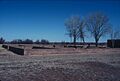
Fort Sumner Ruins: A Significant Historical Site

The Fort Sumner Ruins are perhaps one of the most historically significant sites in the area. This location is part of the larger Fort Sumner Historic Site/Bosque Redondo Memorial. It played a very important role in the history of the Navajo and Mescalero Apache people. The site was added to the National Register of Historic Places on August 13, 1974. While its exact address is restricted for preservation, it is a key historical landmark near Fort Sumner.
Images for kids
-
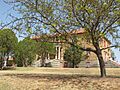
De Baca County Courthouse
-
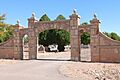
Fort Sumner Cemetery Wall and Entry
-
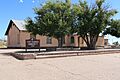
Fort Sumner Community House
-
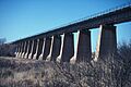
Fort Sumner Railroad Bridge
-
Fort Sumner Ruins
