
National Register of Historic Places listings in Mora County, New Mexico facts for kids

Welcome to Mora County, New Mexico! This area is full of amazing places that are super important to history. These special spots are listed on the National Register of Historic Places. Think of it like a hall of fame for buildings, sites, and districts that tell us about the past.
In Mora County, there are 23 places on this special list. Two of these are even more important and are called National Historic Landmarks. Every single one of these historic places in Mora County is also recognized by the State of New Mexico. Let's explore some of these cool historical sites!
| Bernalillo – Catron – Chaves – Cibola – Colfax – Curry – De Baca – Doña Ana – Eddy – Grant – Guadalupe – Harding – Hidalgo – Lea – Lincoln – Los Alamos – Luna – McKinley – Mora – Otero – Quay – Rio Arriba – Roosevelt – San Juan – San Miguel – Sandoval – Santa Fe – Sierra – Socorro – Taos – Torrance – Union – Valencia |
Contents
Historic Places in Mora County
Mora County is home to many buildings and areas that have been saved because they teach us about the past. These places show us how people lived, worked, and built communities long ago.
Mills and Stores: Echoes of the Past
Many historic places in Mora County are old mills and stores. These were once busy centers of life, where people would grind grain or buy supplies.
Cassidy Family Buildings
The Cassidy Mill near Cleveland is one such place. It was built to grind grain, which was a vital job for farmers. Imagine the sound of the millstones turning!
Close by, you'll find the Daniel Cassidy and Sons General Merchandise Store. This store, built in 1863, was where people bought everything from food to tools. It was like the main shopping center of its time.
The James J. Cassidy House is another historic building connected to this family. It shows us how important the Cassidy family was to the Cleveland community. There's also the Daniel Cassidy House, which is a private home, so its exact location is kept secret to protect it.
Other Important Mills
The Gordon-Sanchez Mill in Mora is another historic mill. Like the Cassidy Mill, it played a big part in the local economy by processing crops. Its location is also kept private.
The St. Vrain's Mill in Mora is a very famous mill. It was built by Ceran St. Vrain, a well-known trader and businessman in New Mexico's history. This mill helped feed many people in the area.
Historic Stores
The J. P. Strong Store is located where State Roads 21 and 120 meet in Ocate. Stores like this were often the heart of small towns, where people gathered not just to shop but also to share news.
Historic Districts: Whole Neighborhoods of History
Sometimes, it's not just one building that's historic, but a whole group of them or an entire area. These are called historic districts.
La Cueva Historic District
The La Cueva Historic District is about six miles southeast of Mora. This area includes several buildings that show what life was like in a small New Mexico community many years ago. It's a great example of how different historic buildings can come together to tell a bigger story.
Mora and Ledoux Districts
The Mora Historic District covers a significant part of the town of Mora. It includes many buildings that show the town's growth and history.
Near Ledoux, you'll find the Ledoux Rural Historic District and the North Carmen Historic District. These areas preserve the look and feel of rural communities from the past. Their exact locations are kept private.
Forts and Trails: Protecting the Frontier
Mora County was an important place for travel and defense in early New Mexico.
Fort Union National Monument
Fort Union National Monument is a huge and very important historic site. It was a major military fort on the Santa Fe Trail. Soldiers here protected traders and settlers traveling through the area. It was a vital supply depot for the U.S. Army in the Southwest.
Santa Fe Trail Segments
The Ocate Creek Crossing and the Santa Fe Trail-Mora County Trail Segments are parts of the famous Santa Fe Trail that ran through Mora County. This trail was a busy trade route connecting Missouri with Santa Fe, New Mexico. Imagine wagons full of goods rumbling along this very path!
Other Notable Historic Sites
Santa Clara Hotel
The Santa Clara Hotel in Wagon Mound was an important stop for travelers. Hotels like this were crucial for people journeying across the vast landscapes of New Mexico.
Tipton-Black Willow Ranch Historic District
The Tipton-Black Willow Ranch Historic District is east of Watrous. Ranches played a huge role in the development of New Mexico, and this district helps preserve that history.
Valmora Sanatorium Historic District
The Valmora Sanatorium Historic District near Watrous was once a special hospital. Sanatoriums were places where people went to recover from illnesses, especially tuberculosis, in a healthy environment. This district shows a unique part of medical history.
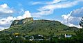
Wagon Mound National Historic Landmark
Wagon Mound is a natural landmark that looks like a covered wagon. It was a very important landmark for travelers on the Santa Fe Trail, letting them know they were getting close to their destination. It's so important it's a National Historic Landmark!
Watrous (La Junta)
The area of Watrous, also known as La Junta, is another National Historic Landmark. It was a key meeting point for different trails and rivers, making it a significant settlement and trading post.
Historic Homes: Glimpses into Daily Life
Several historic homes in Mora County are also on the National Register. These include the Garcia House, the Jose Olquin Barn-Corral Complex, the Desiderio Valdez House, and the Narciso Valdez House. These homes and their related buildings give us a peek into the daily lives of families who lived here long ago. Their exact locations are often kept private to respect the privacy of current residents.
Images for kids
-

The historic Cassidy Mill near Cleveland, New Mexico.
-

The Daniel Cassidy and Sons General Merchandise Store, built in 1863.
-

A view of Fort Union National Monument.
-

A mill and warehouse in the La Cueva Historic District.
-

The historic St. Vrain Mill in Mora.
-
The natural landmark, Wagon Mound.
-
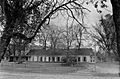
A historic house in the Watrous area.

.jpg)


.jpg)
