
National Register of Historic Places listings in San Bernardino County, California facts for kids

Have you ever wondered about old buildings and places that are super important to history? In San Bernardino County, California, there's a special list of these places! It's called the National Register of Historic Places. This list helps protect buildings, sites, and objects that tell us amazing stories about the past.
There are 99 places in San Bernardino County on this list. One of them is even a National Historic Landmark, which means it's extra special and important to the whole country! Let's explore some of these cool historic spots.
Contents
- Historic Places in San Bernardino County
- A. K. Smiley Public Library
- Aiken's Wash National Register District
- Ancient Archaeological Sites
- Atchison, Topeka and Santa Fe Railway Passenger and Freight Depot
- Auerbacher Home
- Barton Villa
- Beverly Ranch
- Bitter Spring Archaeological Site (4-SBr-2659)
- Black Canyon-Inscription Canyon-Black Mountain Rock Art District
- Bono's Restaurant and Deli
- The California Theatre
- Carnegie Public Library Building
- Cow Camp
- El Garces
- Dr. Orville S. Ensign House
- Euclid Avenue
- First Christian Church of Rialto
- Fontana Farms Company Ranch House, Camp No. 1
- Frankish Building
- Goffs Schoolhouse
- Harvey House Railroad Depot
- Highland Historic District
- Hofer Ranch
- Judson and Brown Ditch
- Kelso Depot, Restaurant and Employees Hotel
- Keys Desert Queen Ranch
- Kimberly Crest
- Sam and Alfreda Maloof Compound
- Mill Creek Zanja
- Moyse Building
- Old San Antonio Hospital
- Ontario and San Antonio Heights Waiting Station
- Pacific Electric Etiwanda Depot
- Pioneer Deep Space Station
- John Rains House
- Redlands Central Railway Company Car Barn
- Redlands Santa Fe Depot District
- Russian Village District
- San Bernardino County Court House
- Shady Point
- Smiley Park Historic District
- Upland Public Library
- US Post Office-Downtown Station (San Bernardino)
- US Post Office-Redlands Main
- Wall Street Mill
- Wigwam Village No. 7
- Yorba-Slaughter Adobe
- Images for kids
Historic Places in San Bernardino County
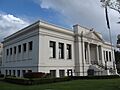
A. K. Smiley Public Library
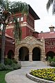
The A. K. Smiley Public Library is located in Redlands, California. It was added to the National Register in 1976. This beautiful library isn't just a place for books; it's a piece of history itself! It's a great example of how important libraries were, and still are, to communities.

Aiken's Wash National Register District
Found within the Mojave National Preserve near Baker, California, the Aiken's Wash National Register District became historic in 1982. This area is important for its natural and historical features, showing us what the desert was like long ago.
Ancient Archaeological Sites
San Bernardino County is home to several ancient sites where people lived thousands of years ago. These include:
- Archeological Site CA SBR 3186: Near Silver Lakes, added in 1981.
- Archeological Site CA-SBR-140: Near Baker, California, added in 2003.
- Archeological Site No. D-4: Near Needles, California, added in 1985.
- Archeological Site No. E-21: Near Parker, California, added in 1985.
These sites are "Address Restricted" to protect them. They help scientists learn about the very first people who lived in California.
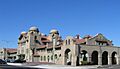
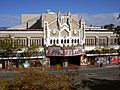
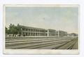
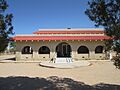
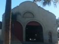
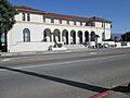
Atchison, Topeka and Santa Fe Railway Passenger and Freight Depot
This historic train station is in San Bernardino, California. It was listed in 2001. Imagine all the people who traveled through here! Train stations like this one were once busy hubs for travel and trade across the country.

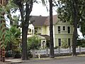
Auerbacher Home
The Auerbacher Home in Redlands, California, became a historic place in 2012. This house is a great example of the architecture and lifestyle from a past era.

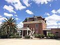
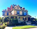
Barton Villa
Also in Redlands, California, the Barton Villa was added to the list in 1996. It's another beautiful historic home that shows us how people lived in the past.

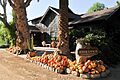
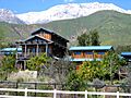
Beverly Ranch
The Beverly Ranch, located in Redlands, California, was recognized as historic in 2004. Ranches like this played a big role in the development of California.

Bitter Spring Archaeological Site (4-SBr-2659)
This site near Barstow, California, was listed in 1982. It's another important archaeological spot that helps us understand ancient cultures.
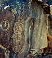
Black Canyon-Inscription Canyon-Black Mountain Rock Art District
Near Hinkley, California, this district was added in 2000. It's famous for its rock art, which are drawings or carvings made by ancient people on rocks. These artworks tell us about their beliefs and daily lives.

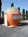
Bono's Restaurant and Deli
This restaurant in Fontana, California, became a historic listing in 2008. It's cool to think that a place where people still eat today can also be a part of history!

The California Theatre
The California Theatre in San Bernardino, California, was added to the list in 2009. This old theater once hosted many shows and movies. It reminds us of how people enjoyed entertainment in the past.

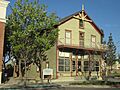
Carnegie Public Library Building
In Colton, California, this library building was listed in 1988. Many towns received money from Andrew Carnegie to build libraries, and this is one of them. Today, it houses the Colton Area Museum.

Cow Camp
Located southwest of Twentynine Palms, California in Joshua Tree National Park, Cow Camp was added in 1975. This site shows us how ranchers lived and worked in the desert.

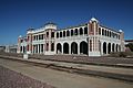
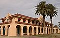
El Garces
El Garces in Needles, California, was listed in 2002. It was once a grand hotel and train station, known as a "Harvey House." These places were famous for their good food and service for train travelers.

Dr. Orville S. Ensign House
This house in Ontario, California, became historic in 2012. It's named after Dr. Orville S. Ensign, an important person in the community's history.

Euclid Avenue
This long road, stretching from Upland, California to Ontario, California, was listed in 2005. Euclid Avenue is special because of its design and how it helped shape these cities.

First Christian Church of Rialto
This church in Rialto, California, was added to the list in 2003. Historic churches often show us the architectural styles and community life of their time.

Fontana Farms Company Ranch House, Camp No. 1
In Fontana, California, this ranch house was listed in 1982. It represents the early farming history of the area.

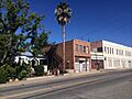
Frankish Building
The Frankish Building in Ontario, California, became historic in 1980. It's an example of early commercial buildings in the city.

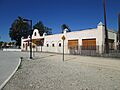
Goffs Schoolhouse
The Goffs Schoolhouse in Goffs, California, was listed in 2001. This old schoolhouse reminds us of what education was like in rural areas many years ago.

Harvey House Railroad Depot
This Harvey House in Barstow, California, was added to the list in 1975. Like El Garces, it was a vital stop for train passengers, offering food and lodging.

Highland Historic District
This district in Highland, California, was listed in 2001. Historic districts are areas with many old buildings that together tell a story about a town's past.

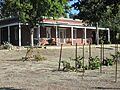
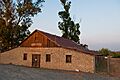
Hofer Ranch
The Hofer Ranch in Ontario, California, became historic in 1993. This ranch played a part in the agricultural history of the region.

Judson and Brown Ditch
This historic ditch, stretching from Highland to Redlands, was listed in 2015. It's an important example of early water systems built to bring water to farms and towns.

Kelso Depot, Restaurant and Employees Hotel
Located in Kelso, California, this large building was listed in 2001. It was a major stop on the Union Pacific Railroad, serving as a depot, restaurant, and hotel for railroad workers and travelers.

Keys Desert Queen Ranch
Another site in Joshua Tree National Park, the Keys Desert Queen Ranch was listed in 1975. It was the home and ranch of Bill Keys, a desert pioneer, and shows how people made a living in this tough environment.

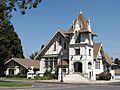
Kimberly Crest
Kimberly Crest in Redlands, California, was added to the list in 1996. This grand mansion is a beautiful example of Victorian architecture and is now a museum.

Sam and Alfreda Maloof Compound
This unique compound in Alta Loma was listed in 2010. It was the home and workshop of Sam Maloof, a famous furniture designer.

Mill Creek Zanja
The Mill Creek Zanja, located in Redlands, California, was listed in 1977. This is one of the oldest irrigation ditches in California, built by Native Americans and later used by Spanish settlers. It's a testament to early engineering!

Moyse Building
The Moyse Building in Chino, California, was added to the list in 1979. It's an important historic building in the downtown area of Chino.

Old San Antonio Hospital
This former hospital in Upland, California, was listed in 1980. It shows the history of healthcare in the region.

Ontario and San Antonio Heights Waiting Station
In Upland, California, this waiting station was listed in 2012. It was a stop for a streetcar line, showing how people traveled before cars were common.

Pacific Electric Etiwanda Depot
This depot in Rancho Cucamonga, California, was added in 2011. It was part of the Pacific Electric Railway, a huge electric train system that connected many Southern California communities.

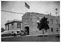
Pioneer Deep Space Station
Located at the Goldstone Deep Space Communications Complex near Fort Irwin, this station was listed in 1985. It's a National Historic Landmark because of its role in space exploration, like communicating with spacecraft far out in space!

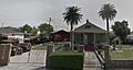
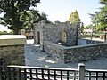
John Rains House
The John Rains House in Rancho Cucamonga, California, was listed in 1973. This historic adobe house gives us a peek into life on a 19th-century rancho.

Redlands Central Railway Company Car Barn
This car barn in Redlands, California, was added in 1991. It was where streetcars were stored and repaired, showing the history of public transportation in Redlands.

Redlands Santa Fe Depot District
This district in Redlands, California, was listed in 1991. It includes the old Santa Fe train station and surrounding buildings, showing the importance of the railroad to the city's growth.

Russian Village District
This unique district in Montclair, California, was listed in 1978. It's called the "Russian Village" because of its distinctive architectural style, which was inspired by Russian designs.

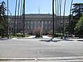
San Bernardino County Court House
The courthouse in San Bernardino, California, was added to the list in 1998. This building is where important legal decisions for the county have been made for many years.

Shady Point
Shady Point in Lake Arrowhead, California, was listed in 2009. This property is a historic part of the beautiful Lake Arrowhead area.
Smiley Park Historic District
This district in Redlands, California, was listed in 1994. It's named after the Smiley family, who were very important in developing Redlands, including the famous A. K. Smiley Public Library.
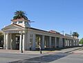
Upland Public Library
The Upland Public Library in Upland, California, was listed in 1990. It's another example of a Carnegie Library, showing the importance of public libraries in communities.
_courtesy_of_Upland_Public_Library.jpg)
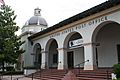
US Post Office-Downtown Station (San Bernardino)
This post office in San Bernardino, California, was listed in 1985. It's a historic building where people have sent and received mail for decades.

US Post Office-Redlands Main
The main post office in Redlands, California, was also listed in 1985. Like the San Bernardino post office, it's an important part of the city's history and architecture.

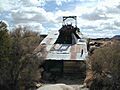
Wall Street Mill
Located south of Twentynine Palms, California in Joshua Tree National Park, the Wall Street Mill was listed in 1975. This old mill was used to process ore from mines, showing the area's mining history.

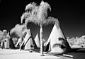
Wigwam Village No. 7
This unique motel in San Bernardino, California, was listed in 2012. It's famous for its teepee-shaped rooms, which were a popular roadside attraction in the mid-20th century.

Yorba-Slaughter Adobe
Located south of Chino, California, the Yorba-Slaughter Adobe was listed in 1975. This adobe house is one of the oldest buildings in the county and tells the story of early California settlers.

Images for kids
-
The A. K. Smiley Public Library in Redlands.
-
The historic Santa Fe Station in San Bernardino.
-
The Auerbacher Home.
-
The historic Barton Villa.
-
Beverly Ranch in Redlands.
-
Ancient petroglyphs at Black Mountain.
-
Bono's Restaurant and Deli.
-
The California Theatre.
-
The Colton Area Museum, formerly the Carnegie Public Library.
-
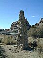
A chimney at Cow Camp in Joshua Tree National Park.
-
El Garces Harvey House and Railroad Depot.
-
The Dr. Orville S. Ensign House.
-
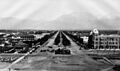
Euclid Avenue in Ontario, California, around 1885.
-
The First Christian Church of Rialto.
-
The Fontana Farms Company Ranch House.
-
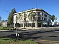
The Frankish Building.
-
The Goffs Schoolhouse.
-
The Harvey House Railroad Depot in Barstow.
-
A view of the Highland Historic District.
-
The Hofer Ranch.
-
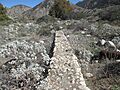
A section of the Judson and Brown Ditch.
-
The Kelso Depot, Restaurant and Employees Hotel.
-
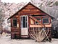
The guest house at Keys Desert Queen Ranch.
-
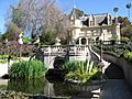
Kimberly Crest House and Gardens.
-
The Sam and Alfreda Maloof Compound.
-
The historic Mill Creek Zanja.
-
The Moyse Building.
-
The Old San Antonio Hospital.
-
The Ontario and San Antonio Heights Waiting Station.
-
The Pacific Electric Etiwanda Depot.
-
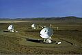
The Goldstone Deep Space Communication Complex.
-
The John Rains House.
-
The Redlands Central Railway Company Car Barn.
-
The Redlands train station.
-

A building in the Russian Village Historic District.
-
The San Bernardino County Courthouse.
-
The Upland Public Library and fire station (circa 1915).
-
The San Bernardino Main Post Office.
-
The Post Office in Redlands.
-
The Wall Street Mill.
-
Wigwam Village No. 7.
-
The Yorba-Slaughter Adobe.
