
New Jersey Route 139 facts for kids
Quick facts for kids
|
||||
|---|---|---|---|---|
|
Route 139 in red
|
||||
| Route information | ||||
| Maintained by NJDOT and PANYNJ | ||||
| Length | 3.32 mi (5.34 km) | |||
| Existed | 1988–present | |||
| Mainline | ||||
| Length | 2.49 mi (4.01 km) | |||
| West end | ||||
| Major junctions |
||||
| East end | ||||
| Upper level | ||||
| Length | 0.83 mi (1.34 km) | |||
| West end | ||||
| East end | ||||
| Location | ||||
| Counties: | Hudson | |||
| Highway system | ||||
| New Jersey State Highway Routes Interstate and US
|
||||

Route 139 is a special road in Jersey City, New Jersey. It goes east from the Pulaski Skyway over a big traffic circle called Tonnele Circle. It ends at the border between New Jersey and New York inside the Holland Tunnel, which goes under the Hudson River to New York City.
This road is unique because part of it has two levels! The lower part is called Route 139. It stretches about 1.45 miles (2.33 km) from U.S. Route 1/9 over Tonnele Circle to Interstate 78 (I-78) at Jersey Avenue. The upper part is about 0.83 miles (1.34 km) long. It's sometimes called Route 139U or Hoboken Avenue. This upper road starts at County Route 501 (John F. Kennedy Boulevard) and joins the lower highway near Jersey Avenue.
The lower part of Route 139 is very old and important. It has been listed on both the federal and New Jersey lists of historic places since 2005. The eastern part of Route 139, about 1.32 miles (2.12 km) long, includes the approach to the Holland Tunnel. Here, it shares the road with Interstate 78. This section uses two one-way streets: 12th Street for eastbound traffic and 14th Street for westbound traffic. The total length of Route 139, including the shared part, is about 2.77 miles (4.46 km).
What we now call Route 139 was once part of a bigger road project called the Route 1 Extension. This was in the early 1900s. Over the years, the road's name changed several times. In the 1990s, it finally became Route 139. Since 2005, the New Jersey Department of Transportation (NJDOT) has been working to fix up both the lower and upper parts of the highway. Many of these repairs were finished by 2010, and more work was completed by 2019.
Contents
What is Route 139 Like?
Route 139 is actually made up of three main parts. Even though they are connected, they work a bit differently. These parts are:
- The upper level
- The lower level
- The Holland Tunnel approach (which shares the road with Interstate 78)
NJDOT sees the lower and upper levels as separate roads. The lower level is officially Route 139. The upper level is sometimes called Route 139U.
The Lower Level: A Fast Road
The lower level of Route 139 is a four-lane highway built for fast travel. It starts where the Pulaski Skyway ends, over Tonnele Circle. There's a special ramp, called the Tonnele Circle Viaduct, that goes over the circle. This ramp helps cars heading west connect to other major roads like U.S. Route 1/9 Truck and Route 7, which leads to Interstate 280.
After the skyway, the road goes through a "cut" in Bergen Hill. It passes under John F. Kennedy Boulevard. The road then turns southeast. It goes under a railroad line and enters a covered section. This part is known as the Depressed Highway. It runs under the upper level of Route 139 as it goes through the Hudson Palisades. This covered road has wide openings on the side for fresh air.
The road comes out from under Palisade Avenue. Then, it splits into two elevated roads, one for eastbound traffic and one for westbound. These two roads then join up with Interstate 78. This happens just west of Jersey Avenue, leading to the Holland Tunnel.
The Upper Level: State Highway

The upper level of Route 139 is also known as State Highway or the Hoboken Avenue Viaduct. It starts at an intersection with County Route 501 (Kennedy Boulevard). This road connects to nearby towns like Bayonne and Union City.
The road goes southeast through neighborhoods with homes and businesses. It starts as a four-lane road without a divider. After Collard Street, it becomes a four-lane divided road. This part runs above the lower level of Route 139. It goes between the Heights area to the north and the Journal Square area to the south.
The upper level crosses several streets, including County Route 646 (St. Pauls Avenue) and County Route 617 (Summit Avenue). After crossing Palisade Avenue, the upper level of Route 139 splits. It then merges with the lower level of Route 139. There's a ramp for westbound traffic and another for eastbound traffic.
Viaducts: Elevated Roads
The 12th Street and 14th Street viaducts are elevated roads. The 12th Street Viaduct was finished in 1927, and the 14th Street Viaduct in 1951. They carry Route 139 between Jersey Avenue (at Boyle Plaza) and the cut in Bergen Hill under Palisade Avenue.
Ramps from the western end of the 12th Street Viaduct connect to the upper level road. The New Jersey Department of Transportation spent $92 million to fix these viaducts. They needed repairs because the steel beams were old and the concrete was too heavy. The project replaced the concrete road surface. It also made the bridges stronger for earthquakes. The repairs were completed in 2010.
Sharing the Road with I-78

The elevated westbound Interstate 78 separates from the 14th Street Viaduct of Route 139. This happens one block west of Jersey Avenue. An elevated road for eastbound Interstate 78 runs next to the eastern part of the 12th Street Viaduct.
Route 139 then joins Interstate 78. From here, Route 139 continues east, sharing the road with I-78. It goes through business areas using two one-way streets: 12th Street for eastbound traffic and 14th Street for westbound traffic. This part of the road is managed by the Port Authority of New York and New Jersey. This area is also known as Boyle Plaza.
The road crosses Jersey Avenue, which leads to Downtown Jersey City and Hoboken. It also crosses other streets like Grove Street and County Route 637 (Marin Boulevard), which is near the Newport Centre Mall.
After these intersections, eastbound traffic reaches the toll plaza for the Holland Tunnel. From here, Route 139 and I-78 enter the Holland Tunnel. This tunnel goes under the Hudson River and has two lanes in each direction. Route 139 officially ends at the New Jersey and New York state line inside the tunnel. Interstate 78 then continues into New York City.
History of Route 139
How the Road Got Its Name
What is now the lower level of Route 139 was first called the northern part of the Route 1 Extension. The New Jersey Legislature approved this road in 1922. It was meant to connect Elizabeth to the Holland Tunnel in Jersey City. When the U.S. Highway System was created in 1926, this road also became part of U.S. Route 1.
In 1927, this highway became part of Route 25. This longer road was planned to go from the Benjamin Franklin Bridge in Camden all the way to the Holland Tunnel.

In 1953, the Route 25 name was changed again. The section from the Pulaski Skyway over Tonnele Circle to the Holland Tunnel became U.S. Route 1/9 Business. By the 1990s, this road was renamed to NJ Route 139.
Along with the Pulaski Skyway, most of the Route 139 lower level was recognized as an important historical site. It was added to both the state and federal lists of historic places in 2005.
The Newark Bay Extension of the New Jersey Turnpike for Interstate 78 opened in 1956. This new road helped connect the New Jersey Turnpike to the Holland Tunnel. Route 139 and I-78 were then set up to share the road where they joined near Jersey Avenue. This shared section goes all the way to the New York state line inside the Holland Tunnel.
Connecting to the Holland Tunnel and Pulaski Skyway
As part of the Holland Tunnel project, some streets in Jersey City were made wider. 12th Street and 14th Street were widened from Jersey Avenue to Provost Street. This helped traffic flow better to and from the tunnel.
The 12th Street Viaduct, an elevated road from Jersey Avenue to the top of Bergen Hill, opened on July 4, 1927. The 14th Street Viaduct, a four-lane, westbound elevated road, opened on February 13, 1951. This 1,800-foot (550 m) viaduct was built to make it easier for cars to get to and from Jersey Avenue.
The Port of New York Authority, which took over the Holland Tunnel in 1930, built the 14th Street Viaduct. The western end of the 12th Street Viaduct was changed from two-way traffic to one-way, eastbound traffic. This change happened in 1956 to help it merge with the eastbound New Jersey Turnpike extension (I-78).

In 1928, the lower level of the highway was completed. This was the first step in creating a fast connection between the Holland Tunnel and Newark. The upper level of Route 139 (Hoboken Avenue Viaduct) also opened. It provided a multi-lane road from Palisades Avenue to John F. Kennedy Boulevard.
The fast highway connection was fully completed when the Pulaski Skyway opened in 1932. The original ramp from the Pulaski Skyway was later replaced. New, longer ramps were built for eastbound and westbound traffic. These ramps connect from the cut in Bergen Hill, just west of John F. Kennedy Boulevard. On September 14, 1938, a direct ramp, called the Tonnele Circle Viaduct, opened. This ramp goes over Tonnele Circle. It helps westbound traffic connect to southbound U.S. Route 1/9 Truck, which leads to Route 7 and Interstate 280.
Recent Years and Improvements
In 1989, Governor Thomas Kean suggested building the Bergen Arches Expressway. This four-lane road would connect the Jersey City waterfront to a new railroad line. This would help people get to the Meadowlands Sports Complex. Many people supported this idea, hoping it would bring more development and ease traffic on Route 139. However, by 2002, plans for a highway were dropped. Leaders in Jersey City preferred a public transit line instead.
In 2011, Governor Chris Christie made a decision that caused some debate. He asked the Port Authority of New York and New Jersey to use money meant for a rail project to fund highway projects instead. The agency agreed to pay $1.8 billion. This money helped pay for fixing the Pulaski Skyway and Route 139, as well as other important road projects in the Port of New York and New Jersey.
The Route 139 project included fixing the eastbound side of the Hoboken Avenue Viaduct. It also resurfaced the westbound road. Many intersections on the upper roadway were improved, and old overpasses were replaced. The project also replaced parts of the Conrail Viaduct. The total cost was estimated to be between $180 and $200 million. The work was expected to be finished by 2016, but it was later pushed back to 2019. The Pulaski Skyway reopened in mid-2018. The lower level of Route 139 was temporarily fully open in December 2018, but then had some partial closures in early 2019 for more work. In 2019, new lighting and road markings were added to Route 139's lower level.
Images for kids
-
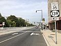
The upper level of Route 139 westbound
-
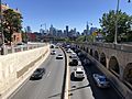
View eastbound along Route 139 from Palisade Avenue, with the Jersey City and Manhattan skylines visible ahead
_and_Hudson_County_Route_663_(Central_Avenue)_in_Jersey_City,_Hudson_County,_New_Jersey.jpg)

_at_the_exit_for_New_Jersey_State_Route_139_WEST_(TO_U.S._Route_1-Interstate_280,_Pulaski_Skyway,_Kennedy_Boulevard,_Jersey_City)_in_Jersey_City,_New_Jersey.jpg)
See also
 In Spanish: Ruta de Nueva Jersey 139 para niños
