
Ob (river) facts for kids
Quick facts for kids Ob |
|
|---|---|

The Ob in Novosibirsk
|
|

Map of the Ob River watershed
|
|
| Country | Russia |
| Region | Altai Krai, Novosibirsk Oblast, Tomsk Oblast, Khanty-Mansi Autonomous Okrug, Yamalia |
| Cities | Biysk, Barnaul, Novosibirsk, Nizhnevartovsk, Surgut |
| Physical characteristics | |
| Main source | Katun Belukha Mountain, Altai Republic 2,300 m (7,500 ft) 49°45′0″N 86°34′0″E / 49.75000°N 86.56667°E |
| 2nd source | Biya Lake Teletskoye, Altai Republic 434 m (1,424 ft) 51°47′11″N 87°14′49″E / 51.78639°N 87.24694°E |
| 3rd source | Most distant source: Ob-Irtysh system near Mang-tai-ch’ia-ta-fan pass, Altai Mountains, Xinjiang, China 2,960 m (9,710 ft) 47°52′39″N 89°58′12″E / 47.87750°N 89.97000°E |
| River mouth | Gulf of Ob Ob Delta, Yamalia 0 m (0 ft) 66°32′02″N 71°23′41″E / 66.53389°N 71.39472°E |
| Length | 3,700 km (2,300 mi) |
| Width |
|
| Depth |
|
| Discharge (location 2) |
|
| Basin features | |
| Basin size | 2,972,497 km2 (1,147,688 sq mi) to 2,994,238 km2 (1,156,082 sq mi) |
| Tributaries |
|
The Ob (Russian: Обь) is a very long river in Russia. It flows through western Siberia. The Ob and its main branch, the Irtysh River, together make up the world's seventh-longest river system. This system is about 5,410 kilometers (3,360 miles) long.
The Ob River starts where two rivers, the Biya and Katun, meet in the Altai Mountains. It is one of three big Siberian rivers that flow into the cold Arctic Ocean. The other two are the Yenisei and the Lena. The Ob flows mostly northwest, then north.
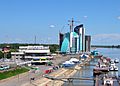
The biggest city along the Ob River is Novosibirsk. It is the largest city in Siberia and the third-largest city in Russia. The famous Trans-Siberian Railway crosses the river in Novosibirsk. The Gulf of Ob, where the river meets the sea, is the world's longest estuary.
Contents
Understanding the Name Ob
The name of the river, Ob, comes from the Russian word Обь (Obʹ). Some experts think it might come from an ancient word meaning "river" or "water." For example, in old Persian, "āb" means water.
Local people have different names for the Ob. The Khanty people call it the As, Yag, Kolta, or Yema. The Nenets people know it as the Kolta or Kuay. The Siberian Tatars call it the Umar or Omass.
Where the Ob River Flows

The Ob River begins about 25 kilometers (15 miles) southwest of Biysk in Altai Krai. It forms where the Biya and Katun rivers join. Both of these rivers start in the Altai Mountains.
The Biya River flows from Lake Teletskoye. The Katun River is about 700 kilometers (435 miles) long and starts from a glacier on Mount Byelukha.
Most of the Ob River is in Russia. However, its smaller rivers (tributaries) reach into northern Kazakhstan, a small part of western China, and a tiny area of western Mongolia. The Irtysh River is the furthest source of the Ob. It starts in China and flows into the Ob around 69° East longitude.
From their starting points to where they meet, the Irtysh is 4,248 kilometers (2,640 miles) long. The Ob itself is 2,538 kilometers (1,577 miles) long from its source to the meeting point.
Main Branches of the Ob
Other important rivers that flow into the Ob include:
- From the east: the Tom, Chulym, Ket, Tym, and Vakh rivers.
- From the west and south: the Vasyugan, Irtysh (which includes the Ishim and Tobol rivers), and Severnaya Sosva.
The Ob River first flows west and then north. It then turns northwest, south of the Siberian Uvaly hills. Finally, it bends northwards and then eastwards into the Gulf of Ob. This gulf is a very long bay, about 1,000 kilometers (620 miles) long, that leads to the Kara Sea. It separates the Yamal Peninsula from the Gyda Peninsula.
Ob River System and Climate
The entire Ob-Irtysh river system is the fourth-longest in Asia. It is about 5,410 kilometers (3,360 miles) long. Its basin, which is the area of land that drains into the river, covers about 2,990,000 square kilometers (1,150,000 square miles).
The land around the Ob River includes different types of environments. These are steppe (grassy plains), taiga (forests), swamps, tundra (cold, treeless plains), and semi-desert. The areas where the Ob often floods have many small rivers and lakes.
The Ob River freezes over in different parts at different times. In the south, near Barnaul, it is frozen from early November until late April. Further north, near Salekhard, it freezes from late October until early June.
The Ob River passes through several climate zones. In the south, the upper Ob valley is warm enough for grapes, melons, and watermelons to grow. But the lower parts of the Ob are in the Arctic tundra, which is very cold. The mildest climates along the Ob are found at Biysk, Barnaul, and Novosibirsk.

How People Use the Ob River


The Ob River is very important for people. It provides water for farms (irrigation) and for drinking. It also generates hydroelectric energy, which is electricity made from moving water. More than 50 types of fish live in the river, making fishing an important activity.
There are several power plants along the Ob River. The largest one is the Novosibirskaya GES.
Transportation and Trade
The Ob River basin has about 15,000 kilometers (9,300 miles) of waterways that boats can use. Before the Trans-Siberian Railway was built, river transport was very important. Even though the Ob and its branches flow mostly north, the wide river basin allowed for travel from east to west too.
In the past, Tyumen was an important river-port in the west. It was on the Tura River, which flows into the Tobol River. Tyumen got a railway link in 1885, connecting it to the Kama and Volga rivers. This made Tyumen a key transport hub for many years. In the east, Tomsk on the Tom River was also an important end point for river travel.
The first steamboat appeared in Tyumen in 1836. By 1916, there were 49 steamboats on the Ob River.
Engineers tried to connect the Ob with the Yenisei River using a system of canals, called the Ob-Yenisei Canal. This canal system was about 900 kilometers (560 miles) long. It was built in the late 1800s but was soon abandoned because the Trans-Siberian Railway was much faster and more efficient.
Even after the Trans-Siberian Railway was completed, the Ob river system remained important. It helped connect large areas like Tyumen Oblast and Tomsk Oblast to major cities along the railway, such as Novosibirsk and Omsk. In the late 1900s, new railway lines were built to cities like Labytnangi, Tobolsk, Surgut, and Nizhnevartovsk. However, the rivers still played a big role in reaching places not served by trains.
Novosibirsk Reservoir
A large dam was built near Novosibirsk in 1956. This dam created the Novosibirsk Reservoir, which was the biggest artificial lake in Siberia at the time.
Cities Along the Ob River
Many cities are located along the Ob River:
- Barnaul
- Kamen-na-Obi
- Novosibirsk
- Kolpashevo
- Langepas
- Megion
- Nizhnevartovsk
- Surgut
- Khanty-Mansiysk
- Beryozovo
- Labytnangi
- Salekhard
Bridges Over the Ob River
Here are some of the bridges that cross the Ob River, listed from where the river starts to its mouth:
- Surgut Bridge
- Railway bridge in Surgut
- Shegarsky bridge
- The bridge of "northern bypass" of Novosibirsk
- Dimitrov bridge in Novosibirsk
- First railway bridge across the Ob (Trans-Siberian Railway)
- Communal (October) bridge in Novosibirsk
- Metro bridge in Novosibirsk – the longest Metro Bridge in the world
- Bugrinsky Bridge
- Komsomol railway bridge in Novosibirsk
- The bridge above the lock of Novosibirskaya HPP
- Railway bridge in Kamen-na-Obi
- Communal bridge (railway, automobile) in Barnaul
- New bridge in Barnaul
Images for kids
-
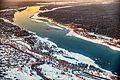
The Ob in Novosibirsk
-
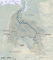
Map of the Ob River watershed
-
Map including the mouth of the Ob River
-
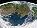
Yenisei and Ob (right) flow into Kara Sea
-
The Ob River in Barnaul
-
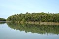
A section of the Ob River
See also
 In Spanish: Río Obi
