
South Beach, Staten Island facts for kids
Quick facts for kids
South Beach
|
|
|---|---|
|
Neighborhood of Staten Island
|
|

South Beach Wetlands
|
|
| Country | |
| State | |
| City | |
| Borough | |
| Community District | Staten Island 2 |
| Area | |
| • Total | 2.34 km2 (0.903 sq mi) |
| Population | |
| • Total | 8,575 |
| • Density | 3,666.5/km2 (9,496/sq mi) |
| Neighborhood tabulation area | |
| Economics | |
| • Median income | $80,361 |
| ZIP Codes |
10305
|
| Area code | 718, 347, 929, and 917 |
South Beach is a neighborhood in Staten Island, New York City. It is located on the East Shore of the island. South Beach is just south of the famous Verrazzano-Narrows Bridge.
The neighborhood is bordered by New York Bay to the southeast. It is next to Midland Beach and other areas like Dongan Hills. South Beach has a popular boardwalk and a beach along its coast. Two small islands, Hoffman Island and Swinburne Island, are located east of the beach.
South Beach is part of Staten Island Community District 2. Its ZIP Code is 10305. The New York City Police Department's 122nd Precinct patrols the area.
Contents
History of South Beach
This area was once known as Graham Beach. It started as a summer beach colony. People would stay in small bungalows and tents. Nearby, there was a housing area called Warren Manor. It was removed in the 1950s.
By the early 1900s, many Italian-Americans moved to South Beach. Their families still make up most of the people living there today.
Fun Times at the Resort
In the mid-1880s, South Beach became a fun place to visit. It had a long boardwalk, a carousel, and other rides. People also enjoyed the beach and having picnics. After some changes in 1890, the area became even better for swimming.
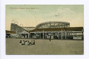
A big fire in September 1896 damaged a lot of the boardwalk. Many hotels and businesses were destroyed. Another large fire happened in 1902. Despite these fires, new attractions were built. For example, a Scenic Railway roller coaster opened in 1899.
Happyland Amusement Park
The 15-acre (6.1 ha) Happyland Amusement Park opened on June 30, 1906. About 30,000 people came to its grand opening! The park had a beach area and a long pier. It was lit up with over 10,000 lights.
Happyland offered many exciting rides. These included a circle swing and an airship ride. There was also a Shoot the Chute water ride. Visitors could also enjoy vaudeville shows and a ballroom. The park had a roller rink and penny arcades.
The park also had beautiful areas like a Japanese garden. There were picnic spots and canals like those in Venice. Shows and music were free. The park was very popular, with 20,000 visitors on summer weekends.
In 1907, a pilot named Lincoln Beachey flew his plane between Happyland and Manhattan. Once, his plane's propeller got tangled with a balloon. He landed safely in the East River.
The amusement park kept going through the 1910s. More independent attractions opened nearby. These included photograph studios and other games. Many roller coasters were built, like the Roller Boller Coaster. In 1919, another big fire damaged the amusement area.
Happyland was rebuilt, but it was not as grand as before. More fires in 1929 destroyed hotels and the boardwalk. Much of the resort was removed in the 1930s. This made way for the South Beach–Franklin Delano Roosevelt Boardwalk, which opened in 1937.
One part of the old amusement area, the 1-acre (0.40 ha) South Beach Amusement Park, stayed open for a long time. It operated until the end of the 20th century. Beachland Amusements, an arcade, was open from 1941 to 2006. It was the last amusement spot on the boardwalk.
South Beach as a Home
In 1949, New York City built a public housing project here. A train line called the South Beach Branch stopped running in 1953. Today, homes stand where the tracks used to be. Only street names like Railroad Avenue remind us of the old railway.
The main road in the neighborhood was once Seaside Boulevard. It ran along the shore next to the boardwalk. This road was later renamed Father Capodanno Boulevard. It is named after a Roman Catholic chaplain who died in the Vietnam War.
Two hospitals are located at the southern edge of South Beach. One is the North Campus of Staten Island University Hospital. The other is the South Beach Psychiatric Center. Wild turkeys began appearing near the Psychiatric Center in the 1990s. They have since spread to other parts of Staten Island.

During Hurricane Sandy in 2012, South Beach was flooded. Many homes were damaged. Some homeowners chose to sell their damaged homes to be torn down. Others decided to stay and rebuild. A large Key Food supermarket opened in 2013 where Beachland Amusements used to be.
South Beach Landscape
The very southern part of South Beach is called Ocean Breeze. This area is low-lying and close to the coast. Because of this, Ocean Breeze often gets the worst flooding after heavy rain. Many streets can become impossible to use. The New Creek bluebelt helps collect rainwater in this area.
People of South Beach
The New York City government groups South Beach with other neighborhoods for census information. This larger area is called Old Town-Dongan Hills-South Beach. In 2010, this area had 24,835 people. Most residents are White (74%). About 13.6% of the population is Hispanic or Latino.
The average life expectancy in this area is 81.2 years. This is similar to the rest of New York City. Many residents are young people and middle-aged adults. About 20% are under 18 years old.
In 2017, the average household income in South Beach was $80,361. About 14% of residents live in poverty. This is lower than the average for all of Staten Island and New York City.
Fire Safety
The New York City Fire Department (FDNY) helps keep South Beach safe. Engine Co. 161/Ladder Co. 81 is located on McClean Avenue.
Post Office and ZIP Code
South Beach uses the ZIP Code 10305. There is no post office directly in South Beach. The closest one is Rosebank Station on Tompkins Avenue.
Education in South Beach

South Beach has a good number of college-educated residents. About 40% of adults aged 25 and older have a college degree or higher. Most students in South Beach and Mid-Island do well in math. The percentage of students doing well in math went up from 49% in 2000 to 65% in 2011.
Fewer elementary school students miss many days of school here. Only 15% of students miss 20 or more days a year. This is better than the city average. Also, 87% of high school students in South Beach graduate on time. This is higher than the city average of 75%.
Schools in the Neighborhood
The New York City Department of Education runs public schools in South Beach and Arrochar:
- PS 39 Francis J Murphy Jr (for grades K-5)
- PS 46 Albert V Maniscalco (for grades PK-5)
Local Library
The New York Public Library has a branch in South Beach. It is located at 21–25 Robin Road. The library first opened in the mid-20th century. It was destroyed in a fire in 1989. The South Beach branch reopened in 1990. It moved to its current location in 2000. The building is one story and 3,000-square-foot (280 m2) big.
Getting Around South Beach

South Beach has many local and express buses. The S78, S79 SBS local buses and SIM1, SIM1C, SIM7, SIM10 express buses stop along Hylan Boulevard. The S51, S81, S52 local buses and SIM5, SIM6, SIM9 express buses use Father Capodanno Boulevard.
South Beach used to have other bus lines, like the X20 and X18. But these were stopped in 2010. The Staten Island Railway also had a South Beach station until 1953.
