
Old Dawson Trail facts for kids
Quick facts for kids Old Dawson Trail |
|
|---|---|
| Lua error in Module:Infobox_road/map at line 15: attempt to index field 'wikibase' (a nil value). | |
| Route information | |
| Length | 530 mi (850 km) |
| Existed | 1871–present |
| Major junctions | |
| East end | Port Arthur (now Thunder Bay), Ontario, Canada |
| West end | St. Boniface (now Winnipeg), Manitoba, Canada |
| Highway system | |
The Old Dawson Trail was a very important path in Canadian history. It was the first route that connected the Great Lakes region with the prairies in a way that stayed completely within Canada. This special path was a mix of land roads and water routes. It started in Port Arthur, Ontario (which is now called Thunder Bay) and ended in St. Boniface, Manitoba (now part of Winnipeg). The parts of the trail that were roads are often called Dawson Road.
Contents
Who Planned the Dawson Trail?
In 1857, the Government of Canada wanted a new way to travel from Lake Superior to the Red River Colony. They didn't want people to have to go through the United States. So, they asked an engineer named Simon James Dawson to find a good route.
Dawson explored the area in 1858. Building the trail began in 1868. The whole trail, including all its roads, was finished in 1871. It was then named after Simon Dawson to honor his work.
What Was the Dawson Trail Like?
The Dawson Trail began as a road heading northwest from Port Arthur. It followed the Shebandowan River to Shebandowan Lake. From there, travelers used a series of lakes and rivers. They went west until they reached the Rainy River and Lake of the Woods. These areas are along the border between Canada and the United States.
After crossing Lake of the Woods, the road continued for about 16 kilometers (10 miles). This small part went through the U.S. at a place called Northwest Angle. Then, the trail went back into Canada to Richer, Manitoba. Finally, it ended at St. Boniface. The entire trail was about 853 kilometers (530 miles) long. Travelers had to load and unload their goods many times, sometimes up to 70 times!
How Was the Trail Used?
The Wolseley Expedition used parts of the trail in 1870. They traveled to the Red River Colony to help stop the Red River Rebellion. This rebellion led to the creation of the Province of Manitoba later that year.
In 1873, about 1,600 people used the Dawson Trail. However, many travelers still preferred a different route. They often chose the easier southern path through Duluth and Emerson. Most of the Dawson Trail was not used as much after the railroad was built. This railroad connected Fort William and Winnipeg in the 1880s. Still, local people continued to use some of the roads.
The Dawson Trail Today
Parts of the Old Dawson Trail are still used today in both Manitoba and Ontario. In Ontario, Highways 102 and 11 follow the old Dawson Road from Thunder Bay to Shebandowan. From Shebandowan, Highway 11 generally follows the original water route west to Rainy River.
In Manitoba, Dawson Road was the first path for Manitoba Highway 12 from St. Boniface to Ste. Anne. This route is now part of Provincial Road 207. It runs between the towns of Richer and Lorette. The old road between Northwest Angle and Richer is mostly broken down. But some parts are now Provincial Roads 503 and 505. You can reach them from the Trans-Canada Highway or Provincial Road 308. Some parts of Dawson Road in Winnipeg are still used. However, they are now separated by the Red River Floodway, the Perimeter Highway, and Lagimodiere Boulevard.
MOM's Way is a group of modern highways. It acts like a new version of the Dawson Road between Winnipeg and Thunder Bay. Highways 102 and 11 in Ontario and Highway 12 south of Ste. Anne in Manitoba are part of this network.
A special stone monument and a plaque were put up in 1933. The Historic Sites and Monuments Board of Canada placed them there to remember the Dawson Road. This monument is next to the local office in Ste. Anne, Manitoba.
Gallery
-
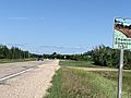
This marker shows the Dawson Trail on Provincial Road 207 in the Rural Municipality of Taché, Manitoba.
-
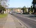
Here is Dawson Road in Thunder Bay, Ontario, in 2008.
-
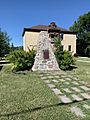
This is the Dawson Road monument in Ste. Anne, Manitoba.
-
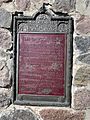
This photo shows the words written on the Dawson Road monument in Ste. Anne, Manitoba.


