
Oronsay, Colonsay facts for kids
| Gaelic name | Orasaigh |
|---|---|
| Norse name | [possibly] Örfirisey |
| Meaning of name | "tidal island" or "Oran's isle" |
 Oronsay Priory and Farm |
|
| OS grid reference | NR351892 |
| Coordinates | 56°01′N 6°14′W / 56.02°N 6.24°W |
| Physical geography | |
| Island group | Inner Hebrides |
| Area | 543 ha (1,340 acres) |
| Area rank | 71 |
| Highest elevation | Beinn Orasaigh, 93 m (305 ft) |
| Administration | |
| Sovereign state | United Kingdom |
| Country | Scotland |
| Council area | Argyll and Bute |
| Demographics | |
| Population | 8 |
| Population density | 1.5/km2 (3.9/sq mi) |
| Largest settlement | Oronsay Farm |
Oronsay (which locals sometimes call Oransay) is a small tidal island in Scotland. It is part of the Inner Hebrides islands. Oronsay is located south of a larger island called Colonsay. The island covers an area of about 543 hectares (1,340 acres).
The highest point on Oronsay is Beinn Orasaigh, which is 93 meters (305 feet) tall. Oronsay is connected to Colonsay by a natural path called An Tràigh (The Strand). This path is made of sand and mud flats. You can only cross it when the tide is low.
In 2011, eight people lived on Oronsay. They lived at the farm near the Oronsay Priory. The island does not have any shops or services for visitors. It is now privately owned, and the RSPB (Royal Society for the Protection of Birds) manages the farm for the owner. There is also a small grass airstrip on the island.
Contents
What's in a Name? The Meaning of Oronsay
The name Oronsay comes from Old Norse words. There are two main ideas about what it means.
One idea is that it means "Oran's Isle." This name would be for St Oran, who some believe started a monastery on the island in 563 AD. Another idea is that it comes from the Old Norse word Örfirisey. This means "island of the ebb tide," which describes how the island is connected to Colonsay at low tide.
Ancient History: Life on Oronsay Long Ago
Oronsay and Colonsay have taught archaeologists a lot about the Mesolithic period. This was a time in prehistory when people were hunter-gatherers. Scientists learned about what people ate by studying old rubbish heaps called middens.
Three middens on Oronsay were explored in the 1880s. They found a bone from around 4600 BC and an oyster shell from 3065 BC. Bones from fish like saithe suggest that people lived on Oronsay all year round. They ate a lot of food from the sea. For some unknown reason, people might not have lived in this area between 5250 and 4750 BC.
There is less evidence from the Neolithic and Bronze Ages. But it seems that small farming groups lived on Colonsay and nearby islands. Technology changed slowly over a long time. By about 500 AD, during the end of the Iron Age, Colonsay and Oronsay were part of the Gaelic-speaking Kingdom of Dál Riata. A fort called Dùn Eibhinn was built on Colonsay around this time. It overlooks Oronsay.
Religious Past and Medieval Times
_(14598471607).jpg)
Some historians think Oronsay might be the island of Hinba. This was a small monastery connected to the Columban church on Iona. Its exact location is not known for sure.
A Norse ship burial was found on Oronsay. Another was found on Colonsay. These date back to the mid-9th century. At this time, these islands were probably part of the Kingdom of the Isles, which was ruled by Norse kings. After the Treaty of Perth in 1266, the Hebrides islands became part of Scotland. The Gaelic language became important again in the southern Hebrides.
Oronsay also had a medieval Augustinian priory, which was a type of monastery. The ruins of this priory can still be seen today. It was built around 1380. It might have been built on the site of an older church. By the early 1500s, artists on Oronsay were making special stone carvings. Two large celtic crosses are outside the priory ruins. Many carved stones with figures are still inside the priory.
Oronsay in Later Centuries (1500s-1700s)

In the 18th century, a visitor named Sir Joseph Banks learned about Murchardus Macdufie. He was a manager for the Lord of the Isles on Oronsay and Colonsay. He was executed in 1539 because he was a bad manager.
The medieval period was a time of great culture on Islay, Jura, and Colonsay. The last known Prior of Oronsay (the head of the priory) was Robert Lamont, chosen in 1555. After the Scottish Reformation in 1560, the priory's lands were given to Malcolm MacDuffie. It seems the monastery stopped existing around this time. The MacDuffie family then used the old fort of Dun Eibhinn as their base.
In 1549, Sir Donald Monro wrote about "Orvansay." He said it was a low island with a monastery. He also mentioned it was "full of hares and polecats." It had a good place for Highland galleys (boats) to anchor. In 1596, a report said that Colonsay and Oronsay together had 100 warriors. These warriors did not have to work the land.
By the early 1600s, land on Colonsay was owned by both Clan Macfie and Clan MacDonald of Dunnyveg. In 1623, a mercenary named Coll Ciotach killed Malcolm MacFie. MacFie was hiding on a small island nearby, but Colkitto's men found him and shot him. After their chief died, the MacFies lost control of their lands. By 1630, Colkitto owned all of Colonsay and Oronsay. However, Colkitto later died in the Wars of the Three Kingdoms. By 1701, the Clan Campbell had sold both islands to a MacNeill family. This family owned the lands until the early 1900s.
In 1703, Martin Martin wrote about Oronsay. He said it was about 6 kilometers (4 miles) around. It was mostly flat, good for farming, and had fertile soil. He also mentioned the church, chapel, and monastery. He saw many burial places with tombstones carved with swords. He described a large cross that was 5 meters (16 feet) high. He also noted that the people of Colonsay would walk around the church in a sun-wise direction before starting any business.
Today, the Colburn family owns the island.
Wildlife on Oronsay

The rocks and small islands of Eilean nan Ròn (Seal Island), to the southwest, are an important place for grey seals to have their babies. This small island has a ruined house. It might have been used by someone who gathered kelp (seaweed). Sheep graze there in the summer. In winter, barnacle geese visit and fertilize the rocks. Dean Monro also mentioned a nearby islet called Eilean Ghaoideamal. He said it was "gude for swine and uther bestiall" (good for pigs and other animals).
To protect the choughs (a type of bird) and corncrakes that live and breed there, Oronsay and southern Colonsay became a Special Protection Area in December 2007.
Colonsay and Oronsay are home to about 50 groups of the European dark bee, called Apis mellifera mellifera. The Scottish Government passed a law in 2013 to protect these bees. This law stops other types of honeybees from being kept on the islands. This helps prevent the dark bees from mixing with other bees and protects them from diseases common on the mainland. Since January 1, 2014, it has been against the law to keep any other honeybee on either island. These bees are now called the "Colonsay Dark Native Bee."
Images for kids
-
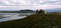
The summit of Beinn Orasaigh with Beinn Eibhne on Colonsay beyond.
-
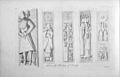
Tombs on Oronsay
-
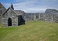
Oronsay Priory was improved in anticipation of Queen Elizabeth's visit.
-
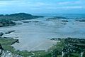
The Strand looking west with Oronsay at left
-
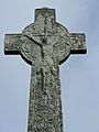
Oronsay cross


See also
 In Spanish: Oronsay para niños
