
Hyderabad State facts for kids
Quick facts for kids
State of Hyderabad
ریاست حیدرآباد
|
|||
|---|---|---|---|
|
Kingdom of Nizams entity
|
|||

The Charminar.
|
|||
|
|||

Hyderabad (yellow) and Berar is not shown (not a part of Hyderabad but also Nizam's Dominion) (surrounded by India.)
|
|||
| Country | |||
| Established | 1947 | ||
| Boroughs |
List
|
||
| Government | |||
| • Type | Principality | ||
| Area | |||
| • Total | 214,190 km2 (82,700 sq mi) | ||
| Population
(1956)
|
|||
| • Total | 19,250,500 | ||
| Time zone | UTC+05:30 (IST) | ||
| Official languages | Telugu, Deccani, Persian and | ||
| It has since been dissolved in 1956 and merged into 3 states on linguistic basis | |||


The State of Hyderabad (Telugu: హైదరాబాదు, Urdu: حیدر آباد) was a very important and large Princely state in south-central India. It existed from 1724 until 1948. This state was ruled by a family of hereditary rulers called the Nizams.
At one point, Hyderabad and the nearby Berar region were the largest princely state in the Indian Empire. The Berar region later became part of Maharashtra in 1903. When British India was divided in 1947, the Nizam of Hyderabad wanted his state to remain independent. However, India decided to include Hyderabad, and it became part of the Union of India in 1948.
Contents
History of Hyderabad State
The rulers of Hyderabad, known as the Asaf Jahi Dynasty, originally came from Central Asia. In 1724, a Mughal governor named Asaf Jah, Nizam ul-Mulk, became an independent ruler in the Deccan region. He first made Aurangabad his capital, but later moved it to Hyderabad. This city then gave its name to the entire state.
The Nizams became close allies with the British. They helped the British fight against other powerful groups like the Maratha dynasty, Tipu Sultan of Mysore, and the French. Hyderabad's troops also fought alongside the British Indian Army in both the First and Second World Wars. Because of these contributions, the Nizams received many special titles and honors from the British Emperor.
Hyderabad's Independence
When India gained independence from British rule in 1947, Hyderabad was the largest of all the princely states. It covered a huge area of about 214,190 km², which is bigger than some countries today. In 1941, about 16.34 million people lived there.
The last Nizam, Osman Ali Khan, Asaf Jah VII, wanted Hyderabad to be an independent country. He did not want to join either the new India or Pakistan. Hyderabad was a very wealthy state. It had its own army, railway system, airline, postal service, radio network, and even its own currency. On August 15, 1947, India became independent, and Hyderabad also declared itself independent.
However, India believed that Hyderabad should join its union. In September 1948, the Indian Army entered Hyderabad. After this event, Hyderabad officially joined India.
Important Dates for Hyderabad
Here are some key dates in the history of Hyderabad State:
- 1687: Hyderabad became part of the Mughal Empire.
- 1720: The Mughal governor, Nizam al-Molk, started to create an independent state.
- 1724: Hyderabad became the capital city of the new state.
- 1766: The British established a protectorate over Hyderabad.
- 1947: The Nizam refused to join India when it became independent.
- 1948: The Indian Army entered Hyderabad, and the state joined India.
- 1956: Hyderabad State was divided and merged into three new states based on language.
State Symbols and Divisions
| State language | Urdu |  |
| State animal | Blackbuck |  |
| State bird | Indian roller |  |
| State tree | Neem tree |  |
| State flower | Blue Water lily | .jpg) |
The State of Hyderabad was divided into four main areas called Divisions, which were further split into 17 Districts. These divisions were:
- Aurangabad
- Gulbarga
- Gulshanabad (Medak) Division
- Warangal
After Hyderabad joined India and the states were reorganized in 1956, the Aurangabad Division became part of Maharashtra. The Gulbarga Division became part of Karnataka. The rest of the state, known as Telangana, was merged with Andhra State to form Andhra Pradesh.
Related pages
Images for kids
-
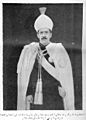
On 22 February 1937, Time magazine called Osman Ali Khan, Asaf Jah VII the wealthiest man in the world.
-
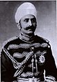
Maharaja Sir Kishen Pershad was the Prime Minister of Hyderabad State for many years.
-
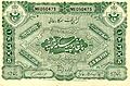
A five rupee banknote from the Hyderabad State.
-
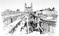
The main street of Hyderabad with the famous Charminar, in 1890.
-
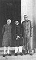
From left to right: Prime Minister Jawaharlal Nehru, Nizam VII, and army chief Jayanto Nath Chaudhuri after Hyderabad joined India.
-
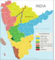
Hyderabad state in 1956 (in yellowish-green). It was later divided into different states.
-
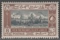
A 1937 stamp from Hyderabad State showing the Osmania General Hospital.
-
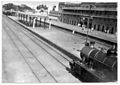
A locomotive at the Secunderabad Station around 1928.
-
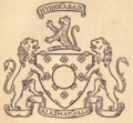
Coat of Arms of Nizam of Hyderabad (1869–1911).
-
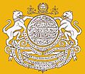
Coat of Arms of Nizam of Hyderabad (1911–1947).
-
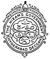
Coat of Arms of Nizam of Hyderabad (1947–1948).
-
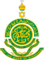
State Emblem of Hyderabad (1947–1948).


See also
 In Spanish: Hyderabad (estado) para niños
