Overton County, Tennessee facts for kids
Quick facts for kids
Overton County
|
|
|---|---|

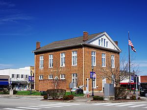
Overton County Courthouse in Livingston
|
|

Location within the U.S. state of Tennessee
|
|
 Tennessee's location within the U.S. |
|
| Country | |
| State | |
| Founded | September 1806 |
| Named for | John Overton |
| Seat | Livingston |
| Largest town | Livingston |
| Area | |
| • Total | 435 sq mi (1,130 km2) |
| • Land | 433 sq mi (1,120 km2) |
| • Water | 1.4 sq mi (4 km2) 0.3%% |
| Population
(2020)
|
|
| • Total | 22,511 |
| • Density | 51/sq mi (20/km2) |
| Time zone | UTC−6 (Central) |
| • Summer (DST) | UTC−5 (CDT) |
| Congressional district | 6th |
Overton County is a county located in the state of Tennessee in the United States. It was founded in September 1806 and named after John Overton, a well-known judge.
As of the 2020 census, about 22,511 people lived here. The main town and county seat is Livingston. Overton County is also part of the Cookeville, TN area, which is a group of towns connected by their economy.
Contents
History of Overton County
Overton County has a long history, including some powerful weather events.
The Beatty Swamps Tornado
On May 10, 1933, a very strong tornado hit a small community called Beatty Swamps. This tornado was about half a mile wide and caused a lot of damage.
It destroyed every building in the town. Sadly, 33 out of 35 people who died in the area were from Beatty Swamps. The tornado was so strong that it cleared away almost all the debris. It even threw a farm machine called a reaper-binder about 500 meters (500 yards) and moved cars hundreds of feet!
Geography of Overton County
Overton County covers a total area of about 435 square miles. Most of this area, about 433 square miles, is land. Only a small part, about 1.4 square miles (0.3%), is water.
Land Features
The county is located on the eastern part of the Highland Rim. This means it has gentle, rolling hills with narrow valleys where creeks flow. The northern part of the county includes areas where the water from Dale Hollow Lake spills over, creating sections like Mitchell Creek and Big Eagle Creek. The county also sits on the Cumberland Plateau, which is a large, flat area of land that is higher than the surrounding land.
Neighboring Counties
Overton County shares its borders with several other counties:
- Pickett County (to the northeast)
- Fentress County (to the east)
- Putnam County (to the south)
- Jackson County (to the west)
- Clay County (to the northwest)
Protected Natural Areas
Several areas in Overton County are protected to preserve nature and wildlife:
- Alpine Mountain Wildlife Management Area
- Jackson Swamp Wildlife Management Area
- Standing Stone State Forest (part of it is in Overton County)
- Standing Stone State Park
Population in Overton County
The population of Overton County has changed over many years.
| Historical population | |||
|---|---|---|---|
| Census | Pop. | %± | |
| 1810 | 5,643 | — | |
| 1820 | 7,128 | 26.3% | |
| 1830 | 8,242 | 15.6% | |
| 1840 | 9,279 | 12.6% | |
| 1850 | 11,211 | 20.8% | |
| 1860 | 12,637 | 12.7% | |
| 1870 | 11,297 | −10.6% | |
| 1880 | 12,153 | 7.6% | |
| 1890 | 12,039 | −0.9% | |
| 1900 | 13,353 | 10.9% | |
| 1910 | 15,854 | 18.7% | |
| 1920 | 17,617 | 11.1% | |
| 1930 | 18,079 | 2.6% | |
| 1940 | 18,883 | 4.4% | |
| 1950 | 17,566 | −7.0% | |
| 1960 | 14,661 | −16.5% | |
| 1970 | 14,866 | 1.4% | |
| 1980 | 17,575 | 18.2% | |
| 1990 | 17,636 | 0.3% | |
| 2000 | 20,118 | 14.1% | |
| 2010 | 22,083 | 9.8% | |
| 2020 | 22,511 | 1.9% | |
| U.S. Decennial Census 1790-1960 1900-1990 1990-2000 2010-2014 |
|||
2020 Census Information
In 2020, the 2020 United States census counted 22,511 people living in Overton County. There were 9,140 households and 6,220 families.
The table below shows the different racial groups in Overton County based on the 2020 census:
| Race | Number | Percentage |
|---|---|---|
| White (non-Hispanic) | 21,223 | 94.28% |
| Black or African American (non-Hispanic) | 86 | 0.38% |
| Native American | 60 | 0.27% |
| Asian | 61 | 0.27% |
| Other/Mixed | 737 | 3.27% |
| Hispanic or Latino | 344 | 1.53% |
Communities in Overton County
Overton County has one main town and several smaller communities.
Town
- Livingston (This is the county seat, meaning it's where the county government is located.)
Unincorporated Communities
These are smaller communities that are not officially organized as towns or cities:
Notable People from Overton County
Many interesting people have come from Overton County:
- Lester Flatt: A famous bluegrass musician.
- Thomas D. Harp: A California state senator who was born in Overton County.
- Albert H. Roberts: A former Governor of Tennessee.
- Roy Roberts: A talented blues singer.
- Catherine "Bonny Kate" Sevier: The wife of John Sevier, who was the very first Governor of Tennessee.
- Cordell Hull: A United States Secretary of State, a very important government position.
- Josiah Gregg: A merchant, explorer, naturalist, and author of a book called Commerce of the Prairies.
- Benoni Strivson: A Medal of Honor recipient for his bravery during the Indian Wars.
See also
 In Spanish: Condado de Overton para niños
 | Claudette Colvin |
 | Myrlie Evers-Williams |
 | Alberta Odell Jones |


