Patapsco Valley facts for kids
Quick facts for kids Patapsco Valley |
|
|---|---|
| Patapsco River Valley | |

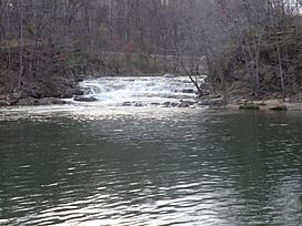
McKeldin Rapids, McKeldin Recreation Area
|
|
| Floor elevation | 260 |
| Length | 39 miles (63 km) North-South |
| Geography | |
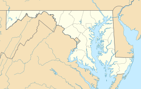
| Location | Anne Arundel County, Baltimore County, Howard County, Carroll County, Maryland |
| Population centers | Brooklyn Park Catonsville Ellicott City Elkridge Lansdowne Linthicum Marriottsville Daniels Hanover Sykesville Woodbine Woodstock |
| Borders on | Elkridge Landing(south) Liberty Reservoir (north) |
| Traversed by | Interstate 70 Interstate 95 Metropolitan Boulevard (I-195) Harbor Tunnel Thruway (I-895) Annapolis Road (MD 648) Belle Grove Road (MD 170) Frederick Road (MD 144) US Route 40 Nursery Road Rolling Road (MD 166) Old Court Road (MD 125) Montgomery Road Old Washington Road (MD 97) Sykesville Road (MD 32) Woodbine Road (MD 94) |
The Patapsco Valley is a beautiful valley in central Maryland. It surrounds the Patapsco River, which flows into the Chesapeake Bay. This area is famous for its important role in history, especially as a center for business and factories in the 1700s and 1800s.
Contents
Exploring the Patapsco Valley
The Patapsco Valley follows the path of the Patapsco River. This river is a big one that eventually empties into the Chesapeake Bay. Most of the valley is covered in trees and has many steep hills, especially as you go north.
The valley starts near Elkridge Landing. From there, it winds north through many old mill towns. The river eventually splits into two parts. One part has the Liberty Dam and its reservoir. This dam is super important because it helps supply water to Baltimore city. The river also flows past towns like Ellicott City and Elkridge.
Patapsco Valley State Park
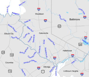
A large part of the valley is protected as Patapsco Valley State Park. This park covers about 14,000 acres (5,700 ha) of land. It stretches along 32 miles (51 km) of the Patapsco River and its smaller streams. Inside the park, the river has carved a deep gorge, about 100 to 200 feet (35–70 meters) deep. You can also see rocky cliffs and pretty waterfalls from smaller streams.
Towns in the Valley
Many communities are located within the Patapsco Valley. Some of these towns include Catonsville, Ellicott City, Elkridge, Woodstock, Daniels, and Hanover. The entire valley is drained by the Patapsco River and all the smaller streams that flow into it.
A Look Back: History of the Valley
The first European to explore the Patapsco River was John Smith. He put it on his map in 1612 and called it the "Bolus River." He named it this because of the reddish clay color of the water. For a long time, the river wasn't easy to travel on past Elkridge. This meant it wasn't a main route for trade.
Railroads and Industry
Later, the Patapsco Valley became very important for transportation. The Baltimore and Ohio Railroad built its first main railway line here, starting in 1829. This railway route is still used today, though it has changed a lot over time. Many old railroad bridges were built in the valley. Two famous ones are the Thomas Viaduct and the Patterson Viaduct, where you can still see some ruins. In the past, the river also powered flour mills and a hydropower dam.
Flooding in the Valley
The Patapsco Valley, especially around Ellicott City, has experienced serious floods over the years. These floods happen when there's a lot of rain.
- In 1868, a flood washed away many houses and caused a lot of damage.
- In 1952, a large wall of water swept through the shops in Ellicott City.
- In 1972, Hurricane Agnes caused major damage to Ellicott City and the old railroad line.
- More recently, in 2016 and 2018, Ellicott City had two very big floods. These floods happened because heavy rain caused water to overflow from smaller streams. Much of Main Street was built over the natural path of a stream, which made the water flow down the street during these storms. Many people believe that too much building and paved surfaces in Ellicott City contribute to these floods.
The Battle of Baltimore
The mouth of the Patapsco River forms the harbor of Baltimore. This was the location of the Battle of Baltimore during the War of 1812. It was here that Francis Scott Key wrote "The Star-Spangled Banner." He was on a British ship and saw the American flag still flying over Fort McHenry after a long night of fighting. Today, a special buoy marks the spot where the British ship HMS Tonnant was anchored.
Wildlife and Nature in the Valley
The Patapsco Valley is a very important place for wildlife in Central Maryland. It's known as a "habitat hub and corridor." This means it's a key area where animals live and can travel safely. Efforts have been made to protect this area through conservation, especially near the Patapsco Valley State Park. The main office for the Howard County Conservancy, an organization that works to protect nature, is located in Woodstock in the upper valley.
Animals and Plants
The valley is home to the typical plants and animals you would find in Central Maryland. You might see many different kinds of trees, flowers, and smaller animals. There have also been several sightings of American black bears in the state park and nearby areas. In 2016, the Maryland Department of Natural Resources Police even filmed a bear in Catonsville, Maryland.


