
Paul Bunyans Stump facts for kids
Quick facts for kids Paul Bunyans Stump |
|
|---|---|

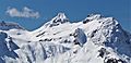
Paul Bunyans Stump seen from North Cascades Highway
|
|
| Highest point | |
| Elevation | 7,480 ft (2,280 m) |
| Prominence | 920 ft (280 m) |
| Geography | |

Paul Bunyans Stump
Location in Washington (state)
|
|
| Location | North Cascades National Park Whatcom County Washington, U.S. |
| Parent range | North Cascades Cascade Range |
| Topo map | USGS Diablo Dam |
| Climbing | |
| First ascent | August 2, 1931 by William Degenhardt and Herbert Strandberg |
| Easiest route | Scramble (class 3) |
Paul Bunyans Stump is a mountain in the North Cascades of Washington, USA. It stands tall at 7,480+ ft (2,280+ m). You can find it inside North Cascades National Park. This mountain rises steeply from Diablo Lake, which is a big lake on the Skagit River.
Paul Bunyans Stump is part of a group of mountains that stretch south towards other climbing spots like Colonial Peak and Snowfield Peak. Its closest neighbor is Pinnacle Peak, just 0.37 mi (0.60 km) north. The nearest taller mountain is Neve Peak, about 0.9 mi (1.4 km) to the southeast. Like many peaks in the North Cascades, Paul Bunyans Stump is famous for how much it rises from the land around it, rather than just its height. Rain and snowmelt from the mountain flow into Diablo Lake and the Skagit River.
First Climb and How to Get There
The first time someone climbed Paul Bunyans Stump was on August 2, 1931. Two climbers, William Degenhardt and Herbert Strandberg, from the Seattle Mountaineers club, made it to the top. They even gave it a funny nickname: "What's the Matterhorn."
To get to the mountain, climbers usually start on the Pyramid Lake Trail. This trail begins near Diablo Dam on the North Cascades Highway. From Pyramid Lake, climbers need to find their way up Pyramid Arm and onto the Colonial Glacier. The most common way to climb the mountain is by "scrambling" (a mix of hiking and easy climbing) up the southwest side after reaching the Colonial Glacier.
Mountain Weather
Paul Bunyans Stump is in a marine west coast climate zone. This means it gets a lot of weather from the Pacific Ocean. Most weather systems travel northeast towards the Cascade Mountains.
When these weather systems hit the tall peaks of the North Cascades, they are forced upwards. This causes them to drop their moisture as rain or snowfall onto the mountains. This process is called orographic lift. Because of this, the western side of the North Cascades gets a lot of rain and snow, especially in winter.
During winter, it's often cloudy. But in summer, high-pressure systems over the Pacific Ocean usually bring clear skies. Because of the ocean's influence, the snow tends to be wet and heavy. This can lead to a high risk of avalanches.
How the Mountains Formed

The North Cascades are known for their very rugged landscape. They have jagged peaks, tall spires, sharp ridges, and deep valleys carved by glaciers. The amazing shapes and big changes in height across the Cascade Range were created by geological events that happened millions of years ago. These events also led to the different climates you see there.
The Cascade Mountains started forming millions of years ago, during a time called the late Eocene Epoch. At that time, the North American Plate was slowly moving over the Pacific Plate. This movement caused a lot of volcanic activity. Also, small pieces of the Earth's crust, called terranes, came together to form the North Cascades about 50 million years ago.
Later, during the Pleistocene period (which started over two million years ago), glaciers repeatedly moved across the land. As they advanced and retreated, they scraped and shaped the landscape, leaving behind piles of rock debris. The "U"-shaped valleys you see in the rivers today are a result of these glaciers. The combination of the land being pushed up (called uplift) and cracks forming in the Earth's crust (called faulting), along with the action of glaciers, created the tall peaks and deep valleys of the North Cascades.
Images for kids
-
Paul Bunyans Stump

