Pawnee County, Oklahoma facts for kids
Quick facts for kids
Pawnee County
|
|
|---|---|

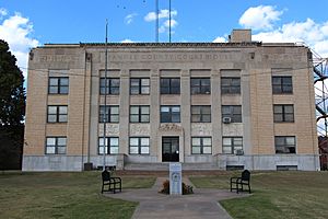
Pawnee County Courthouse, 2014
|
|

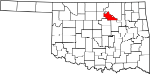
Location within the U.S. state of Oklahoma
|
|
 Oklahoma's location within the U.S. |
|
| Country | |
| State | |
| Founded | 1893 |
| Named for | Pawnee Nation |
| Seat | Pawnee |
| Largest city | Cleveland |
| Area | |
| • Total | 595 sq mi (1,540 km2) |
| • Land | 568 sq mi (1,470 km2) |
| • Water | 27 sq mi (70 km2) 4.5%% |
| Population
(2020)
|
|
| • Total | 15,553 |
| • Density | 26.139/sq mi (10.093/km2) |
| Congressional district | 3rd |
Pawnee County is a county located in the state of Oklahoma, USA. In 2020, about 15,553 people lived there. The main town and county seat is Pawnee. The county gets its name from the Pawnee Nation. Their reservation once covered this area before it was divided up in 1893.
Pawnee County is part of the larger Tulsa metropolitan area. This means it's connected to the bigger city of Tulsa for jobs and activities.
Contents
History of Pawnee County
Early Native American Lands
Long ago, the Osage Nation used the land that is now Pawnee County for hunting buffalo. In 1825, the Osage Nation gave up some of their lands, including parts of what would become Oklahoma, to the U.S. government.
Later, the Cherokee people were moved from the southeastern United States. They received land in eastern Oklahoma, including the Cherokee Outlet in 1828. This area included present-day Pawnee County. After the Civil War, the Cherokee allowed other Native American tribes to settle in the eastern part of the outlet.
The Pawnee Nation Arrives
The Pawnee people sold their reservation in Nebraska in 1874. They used that money to buy land from the Cherokee Nation and the Muscogee Nation. This allowed them to create a new home in what was then called the Indian Territory.
Forming Pawnee County
In 1891, the Pawnee people had to sign an agreement. This agreement meant their reservation lands would be divided into individual plots, or "allotments." If they didn't agree, their lands could be taken by the government. The remaining lands were then opened up for non-Native American settlers in 1893.
Pawnee County was first called County Q. The town of Pawnee, which was Townsite Number 13, was chosen as the county seat. In 1894, people living there voted to name it Pawnee County instead of Platte County.
Geography and Landscape
Land and Water Features
Pawnee County covers about 595 square miles. Most of this area, about 568 square miles, is land. The remaining 27 square miles, or 4.5%, is water.
The western part of the county is flat, open land known as the Red Bed plains. The rest of the county has more hills and is part of the Sandstone Hills region. Two important rivers, the Cimarron and Arkansas Rivers, flow through the county. Black Bear Creek also runs through this area. You can also find Lone Chimney Lake dam in Pawnee County, though the lake itself extends into Payne County.
Neighboring Counties
Pawnee County shares its borders with several other counties:
- Osage County (to the northeast)
- Tulsa County (to the southeast)
- Creek County (to the south)
- Payne County (to the southwest)
- Noble County (to the west)
Earthquake in Pawnee County
On September 3, 2016, a strong earthquake happened near the city of Pawnee. It was a magnitude 5.8 quake, making it Oklahoma's strongest earthquake ever recorded at that time. Some buildings in Pawnee were damaged, but thankfully, no one died. One person was hurt while protecting their child from falling debris.
Population and People
| Historical population | |||
|---|---|---|---|
| Census | Pop. | %± | |
| 1900 | 12,366 | — | |
| 1910 | 17,332 | 40.2% | |
| 1920 | 19,126 | 10.4% | |
| 1930 | 19,882 | 4.0% | |
| 1940 | 17,395 | −12.5% | |
| 1950 | 13,616 | −21.7% | |
| 1960 | 10,884 | −20.1% | |
| 1970 | 11,338 | 4.2% | |
| 1980 | 15,310 | 35.0% | |
| 1990 | 15,575 | 1.7% | |
| 2000 | 16,612 | 6.7% | |
| 2010 | 16,577 | −0.2% | |
| 2020 | 15,553 | −6.2% | |
| U.S. Decennial Census 1790-1960 1900-1990 1990-2000 2010 |
|||
In 2000, there were 16,612 people living in Pawnee County. The population density was about 11 people per square kilometer. Most residents, about 82.27%, identified as White. About 12.13% identified as Native American. A smaller number of people identified as Black or African American, Asian, or Pacific Islander. About 4.42% of the population identified as two or more races. In 2020, the population was 15,553.
Communities in Pawnee County
Pawnee County has several towns and cities.
Cities
Towns
Unincorporated Communities
These are smaller places that are not officially organized as cities or towns.
- Mule Barn (This used to be a town.)
- Quay (Part of this community is also in Payne County.)
- Shady Grove (This also used to be a town.)
Historic Places in Pawnee County
Many places in Pawnee County are listed on the National Register of Historic Places. This means they are important historical sites.
- Arkansas Valley National Bank, Pawnee
- Blackburn Methodist Church, Blackburn
- Blue Hawk Peak Ranch, Pawnee
- Corliss Steam Engine, Pawnee
- First State Bank of Maramec, Maramec
- Mullendore Mansion, Cleveland
- Pawnee Agency and Boarding School Historic District, Pawnee
- Pawnee Armory, Pawnee
- Pawnee County Courthouse, Pawnee
- Pawnee Indian Agency, Pawnee
- Pawnee Municipal Swimming Pool and Bathhouse, Pawnee
- Ralston Opera House, Ralston
See also
 In Spanish: Condado de Pawnee (Oklahoma) para niños
 | Percy Lavon Julian |
 | Katherine Johnson |
 | George Washington Carver |
 | Annie Easley |

