
Pennsylvania Canal (North Branch Division) facts for kids
Quick facts for kids North Branch Pennsylvania Canal |
|
|---|---|

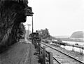
North Branch Canal near Shickshinny in about 1900
|
|
| Specifications | |
| Length | 169 miles (272 km) |
| Locks | 43 |
| Status | Historic, abandoned |
| History | |
| Construction began | 1828 |
| Date completed | 1856 |
| Geography | |
| Start point | Chemung River |
| End point | Susquehanna River |
The North Branch Division of the Pennsylvania Canal was a very old waterway. It stretched for about 169 miles (272 km) (272 km) along the North Branch Susquehanna River. This canal connected southern New York to north-central Pennsylvania.
At its southern end, the North Branch Canal joined other canals. These included the West Branch Canal and the Susquehanna Division Canal. This meeting point was in Northumberland. Up north, it linked up with the Junction Canal and New York's canal system. The canal was built between 1828 and 1856. It was an important part of a big transport network in Pennsylvania.
Contents
Building the Canal: A Big Project
Building the North Branch Canal happened in several steps. It was a huge project for its time!
First Steps: Nanticoke Falls
The first part of the canal was about 55 miles (89 km) (89 km) long. Workers started building it in 1828. This section was finished in 1831 and reached Nanticoke Falls.
Expanding the Canal: Wyoming Extension
In 1834, a project called the Wyoming Extension began. This added another 17 miles (27 km) (27 km) to the canal. It stretched past Wilkes-Barre to Pittston.
Reaching New York: The Final Stretch
The last part of the canal was the longest, about 97 miles (156 km) (156 km). This section went from Pittston all the way to the New York state line. Construction started in 1836 and was completed in 1856.
How Locks Helped Boats Travel
The complete canal had 43 locks. Locks are special sections of a canal that help boats move up or down hills. They work like water elevators. These locks helped boats overcome a total height difference of 334 feet (102 m) (102 m) along the canal. The southern end of the canal was 420 feet (130 m) (128 m) above sea level. The northern end was higher, at 754 feet (230 m) (230 m) above sea level.
Connecting to Other Waterways
A private canal, the Junction Canal, was 18 miles (29 km) (29 km) long. It connected the North Branch Canal to Elmira. In Elmira, the Junction Canal met the Chemung Canal. This canal went north to Seneca Lake and then to the famous Erie Canal. Thanks to these connections, boats could travel from the Pennsylvania Canal system as far as Buffalo and even Lake Champlain. This made it much easier to move goods and people.
The Canal's End: The Railroad Takes Over
In 1858, a company bought the northern part of the canal. This company then sold it to the Lehigh Valley Railroad in 1865. The railroad built train tracks right next to the canal. They even used parts of the canal's towpath, which was the path where horses or mules pulled the boats. The railroad operated both the canal and the tracks for a few years. But in 1872, the state allowed the railroad to close the canal.
The Chenango Extension: A Canal That Wasn't Built
In 1863, New York State planned to build another canal. It was called the Chenango Canal Extension. This canal was supposed to run about 40 miles (64 km) (64 km) along the North Branch Susquehanna River. It would go from Binghamton, New York to the Pennsylvania border.
The plan also included a canal that would cross east to west. This would link the Chenango Canal Extension to the North Branch Canal. However, this project faced many problems. Building it cost more than expected. Also, people were becoming less interested in canals. There were also delays in getting money for the project. Because of these issues, the project was stopped in 1872. Most of the northern part of the canal had been built, but the southernmost 10 miles (16 km) (16 km) were never started.
What's Left Today: Canal Remnants
Even though the canal is gone, you can still find parts of it today!
- In Salem Township, about 8 miles (13 km) (13 km) south of Wilkes-Barre, there's a place called Susquehanna Riverlands. Here, you can walk along about 0.5 miles (0.8 km) (0.8 km) of a path where the canal used to be.
- Lock No. 1 and a section of the original canal in Northumberland were still there in 1986. Lock No. 2, below Bloomsburg, was also intact.
- You can sometimes see parts of the canal bed between Shickshinny and West Nanticoke. The guard lock at West Nanticoke is also still standing.
- Other parts of the canal bed are visible from the Lackawanna River towards Ransom.
- In Laceyville, there's a museum called the Oldest House. This building was once a home for a lockkeeper, someone who operated the canal locks.
- You might also find other small pieces of the canal along its old path. These include old crib work (wooden structures), canal embankments (raised banks), iron spikes, and wooden timbers.
Images for kids
-
Hanging rock, road, railroad, canal, and Susquehanna River near Catawissa in about 1890–1901

