
Pepper Pike, Ohio facts for kids
Quick facts for kids
Pepper Pike, Ohio
|
||
|---|---|---|

Pepper Pike
|
||
|
||
| Motto(s):
"A Great Place to Live and Work"
|
||

Location in Cuyahoga County and the state of Ohio.
|
||
| Country | United States | |
| State | Ohio | |
| County | Cuyahoga | |
| Area | ||
| • Total | 7.15 sq mi (18.53 km2) | |
| • Land | 7.12 sq mi (18.44 km2) | |
| • Water | 0.03 sq mi (0.09 km2) | |
| Elevation | 1,056 ft (322 m) | |
| Population
(2020)
|
||
| • Total | 6,796 | |
| • Density | 954.36/sq mi (368.49/km2) | |
| Time zone | UTC-5 (Eastern (EST)) | |
| • Summer (DST) | UTC-4 (EDT) | |
| ZIP codes |
44122, 44124
|
|
| Area code(s) | 216, 440 | |
| FIPS code | 39-61686 | |
| GNIS feature ID | 1044373 | |
| Website | http://www.pepperpike.org/ | |

Pepper Pike is a city in eastern Cuyahoga County, Ohio, United States. It is a suburb of Cleveland and part of the larger Cleveland metropolitan area. In 2020, about 6,796 people lived there.
Contents
History of Pepper Pike
In 1763, some of the first settlers arrived in the area that is now eastern Cuyahoga County. Around that time, a larger area called Orange Township was created. This township included what we now know as Pepper Pike, along with other nearby towns like Hunting Valley and Moreland Hills.
Birthplace of a President
Did you know that President James A. Garfield was born in Orange Township in 1831? He later became the 20th President of the United States!
From Farms to a City
By the late 1800s, dairy farming and making cheese were the main jobs in the township. In 1924, people living in the northwestern part of Orange Township decided to form their own village, and that's how Pepper Pike was officially started. The name "Pepper Pike" might have come from the Pepper family, who lived and worked along a main road (a "turnpike") there.
Pepper Pike became a city in 1970. It is run by a mayor and a city council. In the late 2000s, it was even listed as one of the top seven "strangest city names" by the World Book of Facts!
Green Spaces and Homes
The city has a rule that homes must be built on at least one acre of land. This helps keep the area feeling natural and green. Pepper Pike has also been named a "Tree City USA" many times by the National Arbor Day Foundation. This shows its commitment to caring for trees.
Transportation Changes
Long ago, there were plans to extend a train line, called the RTA's greenline, into Pepper Pike. However, money problems in the 1930s stopped this from happening. Later, in the 1960s, the arrival of the I-271 highway meant that people mostly used cars to get around instead of trains.
Geography of Pepper Pike
Pepper Pike is located in the eastern part of Cuyahoga County, Ohio. Its exact location is 41°28′37″N 81°28′8″W / 41.47694°N 81.46889°W.
The city covers a total area of about 7.09 square miles (18.36 square kilometers). Most of this area, about 7.06 square miles (18.29 square kilometers), is land. Only a small part, about 0.03 square miles (0.08 square kilometers), is water.
People of Pepper Pike
| Historical population | |||
|---|---|---|---|
| Census | Pop. | %± | |
| 1930 | 219 | — | |
| 1940 | 423 | 93.2% | |
| 1950 | 874 | 106.6% | |
| 1960 | 3,217 | 268.1% | |
| 1970 | 5,382 | 67.3% | |
| 1980 | 6,177 | 14.8% | |
| 1990 | 6,185 | 0.1% | |
| 2000 | 6,040 | −2.3% | |
| 2010 | 5,979 | −1.0% | |
| 2020 | 6,796 | 13.7% | |
| 2021 (est.) | 6,830 | 14.2% | |
| Sources: | |||
In 2020, Bloomberg magazine called Pepper Pike the 43rd richest town in America. This means that many families living there have high incomes. The average income for a household was around $190,682.
Most people in Pepper Pike have a good education. About 78.1% of adults over 25 years old have earned a bachelor's degree or even higher.
Population in 2010
According to the census from 2010, there were 5,979 people living in Pepper Pike. These people made up 2,176 households, with 1,753 of them being families.
- Most residents (86.3%) were White.
- About 6.5% were African American.
- About 5.5% were Asian.
- A small number of people were Native American or from other backgrounds.
- About 1.4% of the population identified as Hispanic or Latino.
Many households (31.3%) had children under 18 living with them. Most families (73.5%) were married couples. The average age of people in the city was about 49.2 years old.
Education in Pepper Pike
Pepper Pike is part of the Orange City School District. This district also serves nearby towns like Hunting Valley and Moreland Hills.
- Orange High School is located right in Pepper Pike.
- The Orange Branch of the Cuyahoga County Public Library is also there.
Colleges and Universities
Ursuline College is a liberal arts school in Pepper Pike. It was founded in 1871 and is the oldest Catholic women's college in Ohio. In 2018, about 1,100 students attended Ursuline College. They can choose from many different study programs.
The Japanese Language School of Cleveland (JLSC) used to hold its classes in Pepper Pike at the Lillian and Betty Ratner School. This school helps students learn Japanese.
Cemeteries
- Orange Cemetery, located at Lander Circle & Chagrin Blvd.
Notable People from Pepper Pike
Many interesting people have lived in Pepper Pike, including:
- Matt Dery, a radio personality.
- Vincent Marotta, an entrepreneur who helped create Mr. Coffee.
- Mark Rosewater, the main designer for the popular card game Magic the Gathering.
- JD Samson, a musician and DJ.
- Tara Seibel, an artist and graphic novelist.
- George Stephanopoulos, a well-known political advisor and TV news journalist for ABC News.
- Seth Taft, who is the grandson of former President William Howard Taft.
Surrounding Communities
 |
Lyndhurst | Mayfield Heights | Gates Mills | |
| Beachwood | Hunting Valley | |||
| Orange | Woodmere | Moreland Hills |
Images for kids
-
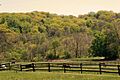
Horses in Pepper Pike
-

Logo of Pepper Pike
-
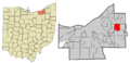
Map showing Pepper Pike's location
See also
 In Spanish: Pepper Pike (Ohio) para niños
