Perris, California facts for kids
Quick facts for kids
Perris, California
|
||
|---|---|---|

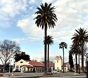
Perris Civic Center
|
||
|
||

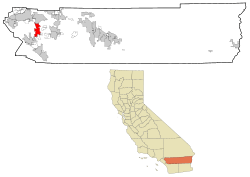
Location in Riverside County and the state of California
|
||
| Country | United States | |
| State | California | |
| County | Riverside | |
| Incorporated | May 26, 1911 | |
| Government | ||
| • Type | Council-manager | |
| Area | ||
| • Total | 31.68 sq mi (82.04 km2) | |
| • Land | 31.57 sq mi (81.76 km2) | |
| • Water | 0.11 sq mi (0.28 km2) 0.35% | |
| Elevation | 1,453 ft (443 m) | |
| Population
(2020)
|
||
| • Total | 78,700 | |
| • Estimate
(2022)
|
80,263 | |
| • Density | 2,542.38/sq mi (981.69/km2) | |
| Time zone | UTC−8 (Pacific) | |
| • Summer (DST) | UTC−7 (PDT) | |
| ZIP Codes |
92570–92572, 92599
|
|
| Area code | 951 | |
| FIPS code | 06-56700 | |
| GNIS feature IDs | 1652772, 2411403 | |
Perris is a city in Riverside County, California, United States. It's about 71 miles (114 km) east of Los Angeles and 81 miles (130 km) north of San Diego. Perris is known for Lake Perris, a human-made lake, and for being a popular spot for skydiving. It also has the Southern California Railway Museum. The city is part of the Inland Empire area in Southern California. In 2020, about 78,700 people lived in Perris.
Contents
History of Perris
Long ago, Native Americans lived in the hills around Perris. Later, Spanish and Mexican miners came to the area.
The city of Perris started because of the California Southern Railroad. A new train station was built there, connecting Barstow and San Diego. Many people from a nearby town called Pinacate moved to Perris in 1885. This happened because of a land dispute. The city was named after Fred T. Perris, who was the chief engineer for the railroad.
Perris officially became a city in 1911. It was first part of San Diego County. But in 1892, it moved to the new Riverside County. In 2005, a special building opened in Perris. It's called the National Archives at Riverside. This building keeps important federal documents for the Pacific Region.
Geography and Climate
Perris covers about 31.68 square miles (82.1 km2) of land. Most of this is dry land, with a small part being water.
Perris's Climate
Perris has a Mediterranean climate. This means it has long, hot summers and short, mild winters. It's often described as a "dry-summer subtropical" climate.
| Climate data for Perris, California | |||||||||||||
|---|---|---|---|---|---|---|---|---|---|---|---|---|---|
| Month | Jan | Feb | Mar | Apr | May | Jun | Jul | Aug | Sep | Oct | Nov | Dec | Year |
| Record high °F (°C) | 87 (31) |
99 (37) |
95 (35) |
98 (37) |
106 (41) |
107 (42) |
110 (43) |
110 (43) |
114 (46) |
101 (38) |
94 (34) |
84 (29) |
114 (46) |
| Mean daily maximum °F (°C) | 65.3 (18.5) |
68.1 (20.1) |
68.3 (20.2) |
74.2 (23.4) |
79.6 (26.4) |
85.3 (29.6) |
96.7 (35.9) |
96.9 (36.1) |
90.8 (32.7) |
82.5 (28.1) |
72.0 (22.2) |
64.5 (18.1) |
78.7 (25.9) |
| Daily mean °F (°C) | 50.0 (10.0) |
52.8 (11.6) |
53.6 (12.0) |
57.9 (14.4) |
63.5 (17.5) |
68.5 (20.3) |
77.1 (25.1) |
77.8 (25.4) |
72.0 (22.2) |
64.8 (18.2) |
56.2 (13.4) |
49.7 (9.8) |
62.0 (16.7) |
| Mean daily minimum °F (°C) | 34.7 (1.5) |
37.5 (3.1) |
38.9 (3.8) |
41.6 (5.3) |
47.5 (8.6) |
51.7 (10.9) |
57.4 (14.1) |
58.7 (14.8) |
53.2 (11.8) |
47.1 (8.4) |
40.5 (4.7) |
34.9 (1.6) |
45.3 (7.4) |
| Record low °F (°C) | 17 (−8) |
23 (−5) |
23 (−5) |
25 (−4) |
34 (1) |
37 (3) |
41 (5) |
41 (5) |
38 (3) |
26 (−3) |
24 (−4) |
12 (−11) |
12 (−11) |
| Average precipitation inches (mm) | 1.63 (41) |
1.93 (49) |
1.29 (33) |
1.04 (26) |
0.16 (4.1) |
0.06 (1.5) |
0.33 (8.4) |
0.06 (1.5) |
0.35 (8.9) |
0.14 (3.6) |
1.97 (50) |
1.45 (37) |
10.42 (265) |
| Average snowfall inches (cm) | 0.2 (0.51) |
0 (0) |
0 (0) |
0 (0) |
0 (0) |
0 (0) |
0 (0) |
0 (0) |
0 (0) |
0 (0) |
0 (0) |
0.2 (0.51) |
0.3 (0.76) |
| Average precipitation days | 4 | 5 | 5 | 4 | 1 | 1 | 1 | 0 | 1 | 1 | 3 | 5 | 30 |
| Source: Western Regional Climate Center | |||||||||||||
People of Perris
| Historical population | |||
|---|---|---|---|
| Census | Pop. | %± | |
| 1920 | 499 | — | |
| 1930 | 763 | 52.9% | |
| 1940 | 1,011 | 32.5% | |
| 1950 | 1,807 | 78.7% | |
| 1960 | 2,950 | 63.3% | |
| 1970 | 4,228 | 43.3% | |
| 1980 | 6,827 | 61.5% | |
| 1990 | 21,460 | 214.3% | |
| 2000 | 36,189 | 68.6% | |
| 2010 | 68,386 | 89.0% | |
| 2020 | 78,700 | 15.1% | |
| 2022 (est.) | 80,263 | 17.4% | |
| U.S. Decennial Census | |||
Perris has grown a lot over the years. In 2010, the city had 68,386 people. Many different groups of people live in Perris. About 71.8% of the people were Hispanic or Latino.
Most people in Perris live in family homes. In 2010, about 66.2% of homes had children under 18. The average household had about 4 people. The median age in Perris was 25.9 years old. This means many young people and families live there.
Economy and Jobs
Perris has many businesses that provide jobs. Here are some of the biggest employers in the city:
| # | Employer | # of Employees |
|---|---|---|
| 1 | Ross Stores, Inc. | 2,193 |
| 2 | Val Verde Unified School District | 1,493 |
| 3 | Perris Union High School District | 1,106 |
| 4 | Lowe's Distribution Center | 926 |
| 5 | Home Depot Distribution Center | 905 |
| 6 | Perris Elementary School District | 701 |
| 7 | NFI Industries | 612 |
| 8 | Eastern Municipal Water District | 600 |
| 9 | Walmart Supercenter | 430 |
| 10 | C R & R Waste | 238 |
Fun Things to Do
The Southern California Railway Museum is a big attraction in Perris. It's the largest working railway museum on the West Coast of the United States. You can see and ride old trains there! The Southern California Fair has also been held at the Lake Perris Fairgrounds since 1987.
The popular restaurant chain Farmer Boys first started in Perris in 1981. There's also a unique building called Rock Castle house. It sits on a hill overlooking the town.
Education in Perris
Several school districts serve the city of Perris. These include:
- The Perris Elementary School District
- The Perris Union High School District (which also serves Menifee)
- The Romoland Elementary School District
- The Menifee Union School District
- The Val Verde Unified School District
Perris High School was the city's first public high school, opening in 1887. Today, there are more high schools like Citrus Hill and Orange Vista. Perris also has several middle schools, including Pinacate, Lakeside, Perris, and Tomas Rivera. There are ten elementary schools for younger students.
Getting Around Perris
Perris Valley Airport and Skydiving
The Perris Valley Airport is a private airport nearby. It has a 5,100-foot (1,600 m) runway. Perris is famous for skydiving. Many people, from beginners to pros, come here to jump out of planes. This has given Perris the nickname "the skydiving capital of America."
Roads and Highways
Interstate 215 runs through Perris. This highway connects the city to Murrieta in the south and San Bernardino in the north. State Route 74 also serves Perris. It connects to Lake Elsinore and Orange County to the west. To the east, it leads to the San Jacinto and Coachella valleys.
Train Travel
In 2016, the 91/Perris Valley Line of the Metrolink train system was extended to Perris. This means you can now take a commuter train from Perris to downtown Los Angeles and other parts of the Greater Los Angeles area. There are two train stations in Perris.
Notable People from Perris
- Bobbi Althoff – a podcaster and social media personality.
- Louis B. Mayer – a famous Hollywood film producer who owned a horse ranch in Perris.
- Alfred E. Green – a film director born in Perris.
- Danny Harris – an Olympic hurdler who won a silver medal in the 1984 Los Angeles Olympic Games. He grew up in Perris and went to Perris High School.
- Elmer Rieger – a baseball player.
- Abraham Placito – a soccer player.
See also
 In Spanish: Perris para niños
 | Valerie Thomas |
 | Frederick McKinley Jones |
 | George Edward Alcorn Jr. |
 | Thomas Mensah |


