
Plateau de Beille facts for kids
Quick facts for kids Plateau de Beille |
|
|---|---|
 |
|
| Location | Ariège, Midi-Pyrénées, France |
| Coordinates | 42°43′31.2″N 1°41′27.15″E / 42.725333°N 1.6908750°E |
| Top elevation | 2,000 m (6,600 ft) |
| Base elevation | 1,650 m (5,410 ft) |
| Skiable area | 70 km (43 mi) |
| Runs | Black: 2, 21 km (13 mi) Red: 5, 32.3 km (20.1 mi) Blue: 5, 14 km (8.7 mi) Green: 1, 1 km (0.62 mi) |
Plateau de Beille (which means Plan de Belha in the Occitan language) is a popular ski resort located high up in the Pyrenees mountains. You can find it in the Ariège area of France, within the Occitanie region. This winter sports spot sits at an elevation of about 1,790 m (5,870 ft).
For many years, Plateau de Beille was mainly used by farmers for their animals, especially cattle. But more recently, it has become a big winter sports resort in the Pyrenees. It's especially famous for cross-country skiing, with trails found between 1,650 and 2,000 metres (5,410 and 6,560 ft) high. The ski area is located between the towns of Tarascon-sur-Ariège and Ax-les-Thermes, not far from the Spanish border. It's also above the smaller towns of Les Cabannes, Albiès, and Vèbre. To get there by road, you take the D522 from Les Cabannes. The Plateau de Beille is also a point along the GR 10 hiking trail, which crosses the entire Pyrenees mountain range.
Since 1998, the challenging climb from Les Cabannes up to the plateau has often been the final climb of a stage in the famous Tour de France cycling race. What's really cool is that on the first four times this happened, the cyclist who won the stage at Plateau de Beille also ended up winning the entire Tour de France that year!
Contents
Exploring Plateau de Beille's Location

The Plateau de Beille is surrounded by two smaller rivers that flow into the Ariège Valley. To the west, there's the Aston river, and to the east, the Labail stream. The plateau ends to the south at the Col de Finestres, a mountain pass at 1,967 metres (6,453 ft), where the GR 10 hiking trail crosses. To the north, the land drops steeply down to the Ariège Valley.
The entire area of Plateau de Beille covers about 1,450 hectares (3,600 acres). Its altitude generally ranges from about 1,700 metres (5,600 ft) to 2,000 metres (6,600 ft).
Plants and Animals at Plateau de Beille
Plateau de Beille is recognized as a special "Natural Zone of Ecological Interest, Fauna and Flora" (ZNIEFF). This means it's an important place for nature.
You'll find different types of natural areas here:
- Short grassy areas
- Forests of special mountain pines called Pinus uncinata at higher altitudes
- Forests with beech and fir trees on the lower slopes
- Moorland areas
- Some bogs (wet, spongy ground)
In the bogs, you can find rare and protected plants like the oblong-leaved sundew (Drosera intermedia) and the round-leaved sundew (Drosera rotundifolia). These plants are special because they are carnivorous, meaning they eat insects! You might also see bog club moss (Lycopodiella inundata), marsh cinquefoil (Comarum palustre), and tussock cottongrass (Eriophorum vaginatum).
When it comes to animals, Plateau de Beille is home to some amazing creatures. You might spot the capercaillie, a large type of grouse, or majestic birds of prey like the golden eagle and the bearded vulture. Among mammals, you could see the European pine marten (Martes martes) and the agile Pyrenean chamois, which is a type of goat-antelope.
Sports and Activities at Plateau de Beille
Skiing and Winter Fun
The Plateau de Beille Nordic ski resort first opened its doors in 1989, after being created in 1988. It offers a fantastic range of winter activities:
- 70 kilometres (43 mi) of trails for cross-country skiing.
- 42 kilometres (26 mi) of trails for snowshoeing.
- A special stadium for biathlon, which combines cross-country skiing and rifle shooting.
- A school where you can learn about dog sledding.
Even in the summer, there are fun things to do! You can try scooters pulled by sled dogs or go on discovery walks to learn about the local farming and animal herding (called pastoralism). There are also mountain biking trails that follow the same paths used for cross-country skiing in winter. Plateau de Beille is mainly a daytime resort, meaning there isn't much overnight accommodation, though you can find some simple shelters for camping.
In 2008, Plateau de Beille was the most popular Nordic ski station in the Pyrenees and the fourth most popular in all of France! It's managed by a local group called RENVA and works with nearby ski resorts like Ax 3 Domaines.
Cycling Challenges
|
Plateau de Beille
|
|
|---|---|

Start of the climb shortly after Les Cabannes
|
|
| Start | Les Cabannes, Ariège |
| Gain in altitude | 1,255 m (4,117 ft) |
| Length of climb | 15.9 km (9.9 mi) |
| Maximum elevation | 1,790 m (5,870 ft) |
| Average gradient | 7.9 % |
| Maximum gradient | 10.8 % |
Plateau de Beille is a well-known spot for various cycling races because of its challenging climb. It was first featured in the Route du Sud race in 1995. Then, the famous Tour de France started using it in 1998. It also regularly serves as the final mountain climb for cyclists in the L'Ariégeoise race.
The Climb to Plateau de Beille
The climb to Plateau de Beille starts from Les Cabannes, which is at an altitude of 535 m (1,755 ft). The top of the climb is at 1,790 m (5,870 ft). This challenging ascent is 15.8 km (9.8 mi) long. Over this distance, cyclists climb a total of 1,255 m (4,117 ft). The average steepness (gradient) is 7.9%, but some parts are even steeper, reaching a maximum of 10.8%.
It's a really tough climb! The first 12 kilometres (7.5 mi) are mostly through a forest, offering some shade. The last 4 kilometres (2.5 mi) are out in the open pastures, where you might even see cattle crossing the road!
Right after leaving the main square of Les Cabannes, cyclists face a very steep section. The road surface is smooth at first but then becomes rougher, adding to the difficulty. The forest section offers very little break from the steepness. The slope is high and steady, with many sharp turns (hairpins). There's a short flat part of about 400 metres (1,300 ft) around the 6th kilometre, but otherwise, the percentages are often higher than 8%. The 9th kilometre, just before the Henry IV fountain, is one of the steepest parts.
After leaving the forest, the slopes are slightly less steep but more uneven. At the 12th kilometre, cyclists pass the Cabanne de Pierrefite. Here, there's a short flat section followed by another very difficult steep part. After another hairpin turn a bit further up, the final section has a more moderate slope. The finish line is at the large car park outside the ski station building, at an altitude of 1,790 metres (5,870 ft).
Plateau de Beille in the Tour de France

Since the Tour de France first used it in 1998, Plateau de Beille has been the finish line for a stage six times. These were in 1998, 2002, 2004, 2007, 2011, and 2015. The climb is considered hors catégorie, which means "beyond category" – it's one of the hardest climbs in the race!
Interestingly, on the first four occasions, the cyclist who won the stage at Plateau de Beille also went on to win the entire Tour de France that year. This happened with Marco Pantani in 1998, Lance Armstrong in 2002 and 2004 (though his titles were later removed), and Alberto Contador in 2007.
Tour de France Stage Winners at Plateau de Beille
| Year | Stage | Start of stage | Distance (km) | Climb Category | Stage Winner | Yellow Jersey (Race Leader) |
|---|---|---|---|---|---|---|
| 2015 | 12 | Lannemezan | 195 | HC | ||
| 2011 | 14 | Saint-Gaudens | 168.5 | HC | ||
| 2007 | 14 | Mazamet | 170 | HC | ||
| 2004 | 13 | Lannemezan | 205.5 | HC | ||
| 2002 | 12 | Lannemezan | 198 | HC | ||
| 1998 | 11 | Bagnères-de-Luchon | 170 | HC |
- In 1998, the finish line was at 1,747 m (5,732 ft), but in later years, it has been at 1,780 m (5,840 ft).
Route du Sud Race
The Plateau de Beille has also been used seven times as a stage finish for the Route du Sud cycling race:
- 1995:
 Carmelo Mirando
 - 1996:
 Giuseppe Guerini
 - 1997:
 Laurent Roux
 - 1998: Armand de Las Cuevas
- 1999:

Lance Armstrong - 2001: Francesco Casagrande
- 2002: Levi Leipheimer (This was an individual time trial, where cyclists race against the clock one by one.)
Images for kids
-
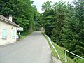
The difficult slope right after leaving Les Cabannes
-
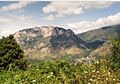
The mountain of Quié de Sinsat at 1,484 metres (4,869 ft)
-
The Pierrefite cabin on the right, about 4 kilometres (2.5 mi) from the finish line
-
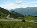
A sharp hairpin turn about 2.5 kilometres (1.6 mi) from the finish
-
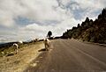
Cattle and horses sometimes cross the road about 1 kilometre (0.62 mi) from the finish
-
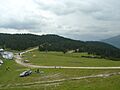
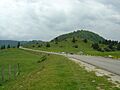
The starting point for the ski slopes
-
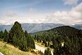
A view looking north towards the Montagne de la Tabe
-
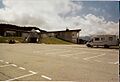
The restaurant at the finish area, next to the large car park


See also
 In Spanish: Plateau de Beille para niños
- List of winter sports stations in the Pyrenees
- List of cols of the Pyrenees
- 2007 Tour de France, stage 14
- 2011 Tour de France, stage 14
