Plattsburgh (town), New York facts for kids
Quick facts for kids
Plattsburgh
|
|
|---|---|
| Town of Plattsburgh | |

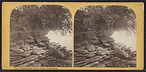
Cumberland Head on Lake Champlain
|
|

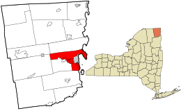
Location in Clinton County and the U.S. state of New York
|
|
| Country | United States |
| State | New York |
| County | Clinton |
| Government | |
| • Type | Town Council |
| Area | |
| • Total | 68.2 sq mi (176.7 km2) |
| • Land | 45.9 sq mi (118.9 km2) |
| • Water | 22.3 sq mi (57.7 km2) |
| Elevation | 276 ft (84 m) |
| Population
(2020)
|
|
| • Total | 11,886 |
| • Density | 258/sq mi (99.8/km2) |
| Time zone | UTC-5 (Eastern (EST)) |
| • Summer (DST) | UTC-4 (EDT) |
| ZIP codes |
12901, 12903
|
| Area code(s) | 518 |
| FIPS code | 36-58585 |
| GNIS feature ID | 0979377 |
Plattsburgh is a town in Clinton County, New York, United States. It had a population of 11,886 people in 2020. The town is named after Zephaniah Platt, who was an early landowner. It completely surrounds the separate and larger City of Plattsburgh. The town is located in the eastern part of Clinton County, within the North Country region of New York State. The area's main airport, Plattsburgh International Airport, is found in the southern part of the town.
Contents
A Look Back: Plattsburgh's History
The town of Plattsburgh was first created in 1785. However, over time, parts of it were used to form other towns in the county. These new towns included Peru (in 1792), Beekmantown (in 1820), Saranac (in 1824), and Schuyler Falls (in 1848). The village of Plattsburgh was officially formed within the town in 1815. It later became a city in 1902.
A very important event, the Battle of Plattsburgh, happened here in 1814. This battle was fought on Lake Champlain during the War of 1812.
Exploring Plattsburgh's Geography
The United States Census Bureau states that the town of Plattsburgh covers a total area of about 68.2 square miles (176.7 square kilometers). Of this, about 45.9 square miles (118.9 square kilometers) is land. The remaining 22.3 square miles (57.7 square kilometers), which is about 32.68% of the total area, is water.
The town is located right next to Lake Champlain. This large lake separates Plattsburgh from the state of Vermont on the other side. The Saranac River flows through the town towards the east, eventually emptying into Lake Champlain.
Major Roads and Highways
Several important highways pass through the town. These include:
- The Adirondack Northway (Interstate 87)
- U.S. Route 9
- New York State Route 22
- New York State Route 3
- New York State Route 22B
- New York State Route 374
- New York State Route 190 (which crosses NY-22B and NY-374)
Plattsburgh's Population and People
| Historical population | |||
|---|---|---|---|
| Census | Pop. | %± | |
| 1820 | 3,519 | — | |
| 1830 | 4,913 | 39.6% | |
| 1840 | 6,416 | 30.6% | |
| 1850 | 5,618 | −12.4% | |
| 1860 | 6,680 | 18.9% | |
| 1870 | 8,414 | 26.0% | |
| 1880 | 8,283 | −1.6% | |
| 1890 | 2,490 | −69.9% | |
| 1900 | 3,178 | 27.6% | |
| 1910 | 2,362 | −25.7% | |
| 1920 | 2,085 | −11.7% | |
| 1930 | 2,132 | 2.3% | |
| 1940 | 3,163 | 48.4% | |
| 1950 | 3,713 | 17.4% | |
| 1960 | 13,390 | 260.6% | |
| 1970 | 15,881 | 18.6% | |
| 1980 | 16,384 | 3.2% | |
| 1990 | 17,231 | 5.2% | |
| 2000 | 11,184 | −35.1% | |
| 2010 | 11,870 | 6.1% | |
| 2020 | 11,886 | 0.1% | |
| U.S. Decennial Census | |||
In the year 2000, there were 11,190 people living in the town. These people lived in 4,367 households, with 3,091 of them being families. The population density was about 244.9 people per square mile (94.6 people per square kilometer).
About 33.8% of households had children under 18 living with them. Most households (55.0%) were married couples living together. About 21.9% of all households were individuals living alone.
The population was spread out by age:
- 25.6% were under 18 years old.
- 7.6% were between 18 and 24.
- 29.7% were between 25 and 44.
- 25% were between 45 and 64.
- 12.2% were 65 years or older.
The average age of people in the town was 37 years.
Communities and Places in Plattsburgh
The town of Plattsburgh is home to several smaller communities and interesting locations:
- Cadyville – A small village in the southwest, located on NY-3 and the Saranac River.
- Champlain Park – A small village on Cumberland Head in the northeast.
- Cliff Haven – A neighborhood by Lake Champlain, just south of the City of Plattsburgh.
- Colligan Point – A spot on the eastern side of Cumberland Head.
- Crab Island – A small island and state park in Lake Champlain, east of Cliff Haven.
- Cumberland Bay – A bay of Lake Champlain, with the City of Plattsburgh on its western shore.
- Cumberland Bay State Park – A state park in the northeast part of the town, on Cumberland Head.
- Cumberland Head – A peninsula that sticks out into Lake Champlain.
- Elsinor – A small village on the western town line, along NY-3 and the Saranac River.
- Everest Rabideau Park – A park located on Cumberland Head.
- Halseys Corners – A small village near the City of Plattsburgh, close to the Northway.
- Lawless Corners – A small village on the northern border of the town, north of West Plattsburgh.
- Martin Point – A spot on the eastern side of Cumberland Head.
- Morrisonville – A village partly located at the southern town line, on NY-22B and the Saranac River.
- Plattsburgh – The City of Plattsburgh is located within what was once the central part of the town.
- Plattsburgh International Airport – This is the main airport for the area. It's built on the site of the old Plattsburgh Air Force Base, south of the City of Plattsburgh.
- Pleasant Ridge Corners – A small village southwest of the city and north of South Plattsburgh.
- Rocky Point – A small village on Cumberland Head.
- South Junction – A small village near Lake Champlain in the southeast.
- South Plattsburgh – A small village near the town line in the southeast, on NY-22.
- Valcour Island – The northern tip of this island is within the town's boundaries.
- West Plattsburgh – A small village in the north-central part of the town on NY-374.
- Woodruff Pond – A small lake north of Cumberland Head.
Census-Designated Places
Some areas within the town are also recognized as Census-Designated Places (CDPs). These are specific areas identified by the U.S. Census Bureau for statistical purposes:
- Cumberland Head
- Morrisonville (partially in the town)
- Parc
- Plattsburgh West
See also
 In Spanish: Plattsburgh (pueblo) para niños
 | Misty Copeland |
 | Raven Wilkinson |
 | Debra Austin |
 | Aesha Ash |


