Plummer Peak facts for kids
Quick facts for kids Plummer Peak |
|
|---|---|

Plummer Peak
|
|
| Highest point | |
| Elevation | 6,374 ft (1,943 m) NAVD 88 |
| Prominence | 410 ft (125 m) |
| Geography | |
| Parent range | Cascades, Tatoosh Range |
| Topo map | USGS Mount Rainier East |
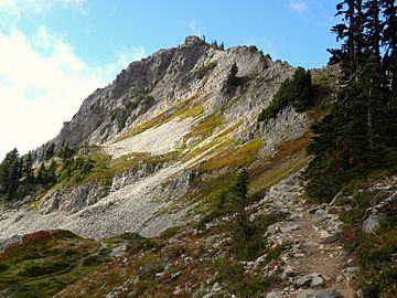
Plummer Peak is a mountain top, also called a summit, located in Mount Rainier National Park in Lewis County, Washington. It stands tall at 6,374 feet (about 1,943 meters) above sea level. This makes it the seventh highest peak in the Tatoosh Range. The peak was named after Fred G. Plummer. He was a mapmaker for the United States Forest Service. He also taught geography in schools in Tacoma.
Contents
Exploring Plummer Peak
What Can You Do There?
Getting to the top of Plummer Peak involves hiking and some scrambling. Scrambling means you might need to use your hands a bit to climb over rocks. The area is also popular for skiing. However, skiers need to be very careful because of the danger of avalanches. An avalanche is a fast-moving slide of snow down a mountain.
Amazing Views from the Top
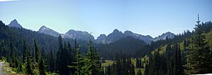
From the summit of Plummer Peak, you can see many amazing sights. You'll get clear views of the famous Mount Rainier. You can also spot the town of Packwood below. Other mountains visible include the Goat Rocks, Mount St. Helens, and Mount Adams.
Features Around the Peak
Near the top of Plummer Peak, there's a small tarn. A tarn is a little mountain lake formed in a basin. There's also a low point between two peaks called a col. This specific col is known as "The Saddle." It forms a walkable ridge that connects Plummer Peak to its nearby neighbor, Pinnacle Peak.
 | James B. Knighten |
 | Azellia White |
 | Willa Brown |


